
Mangrove forest ecological restorability assessment method based on unmanned aerial vehicle hyperspectrum

An ecological restoration and hyperspectral technology, applied in the measurement of color/spectral characteristics, climate change adaptation, etc., can solve the problems of poor interpretability of remote sensing mechanism, difficulty in considering small-scale fluctuations, and ignoring continuous monitoring of growth processes.

Active Publication Date: 2021-06-04
SHENZHEN UNIV
View PDF7 Cites 2 Cited by
  • Summary
  • Abstract
  • Description
  • Claims
  • Application Information

AI Technical Summary

Problems solved by technology

In addition, remote sensing methods often focus on statistical models, but their portability is poor, the accuracy of the models is easily affected by time, place and species, and the interpretation of remote sensing mechanisms is not strong
[0011] (2) Most studies focus on the traits of mangroves at a certain time, ignoring the continuous monitoring of the growth process;
In contrast, natural disturbances to mangroves (such as sea level rise and natural disasters) are global disturbances, affecting a large spatial range, and it is difficult to take into account small-scale fluctuations
In addition, the ecological resilience evaluation index system and the remote sensing methods used in the larger space-time scale are not suitable for smaller-scale research, which is likely to cause large errors and affect decision-making and the proposal of ecological restoration technology.

Method used


Image

  • Mangrove forest ecological restorability assessment method based on unmanned aerial vehicle hyperspectrum
  • Mangrove forest ecological restorability assessment method based on unmanned aerial vehicle hyperspectrum
  • Mangrove forest ecological restorability assessment method based on unmanned aerial vehicle hyperspectrum

Examples


Embodiment Construction

[0066] In order to make the object, technical solution and advantages of the present invention more clear and definite, the present invention will be further described in detail below with reference to the accompanying drawings and examples. It should be understood that the specific embodiments described here are only used to explain the present invention, not to limit the present invention.

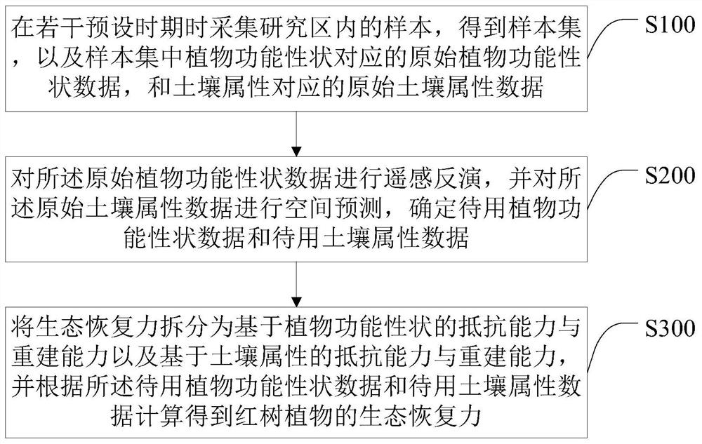
[0067] See figure 1 , figure 1 It is a flow chart of the mangrove ecological resilience assessment method based on UAV hyperspectral in the present invention. Such as figure 1 As shown, the mangrove ecological resilience assessment method based on UAV hyperspectral described in the embodiment of the present invention comprises the following steps:

[0068] S100. Collect samples in the research area during several preset periods to obtain a sample set, original plant functional trait data corresponding to plant functional traits in the sample set, and original soil attribute data corre...


PUM


Abstract

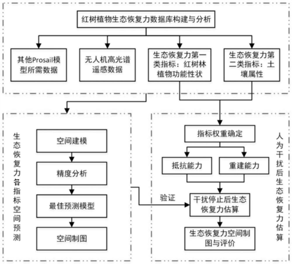
The invention provides a mangrove forest ecological restorability evaluation method based on the unmanned aerial vehicle hyperspectrum, which comprises the steps of collecting samples in a research area in a plurality of preset periods, and obtaining a sample set, original plant function character data corresponding to plant function characters in the sample set and original soil attribute data corresponding to soil attributes in the sample set are obtained; performing remote sensing inversion on the original plant functional character data, performing spatial prediction on the original soil attribute data, and determining to-be-used plant functional character data and to-be-used soil attribute data; splitting the ecological restorability into resistance and reconstruction capability based on plant functional traits and resistance and reconstruction capability based on soil attributes, and calculating the ecological restorability of the mangrove plant according to the standby plant functional trait data and the standby soil attribute data. According to the invention, continuous monitoring of mangrove plant functional traits and soil attributes in a small scale can be completed, and quantitative estimation and evaluation of mangrove plant ecological restorability after interference is stopped are realized.

Description

technical field [0001] The invention relates to the technical field of vegetation ecological restoration, in particular to a method for evaluating mangrove ecological resilience based on UAV hyperspectral. Background technique [0002] Mangroves have ecosystem service functions such as promoting siltation and creating land, preventing waves and embankments, and maintaining biodiversity. Due to unreasonable human development activities, the spatial distribution of mangroves has become fragmented. In addition to natural disturbances (such as disasters, climate change, or sea level rise), more and more human disturbances (domestic and aquaculture sewage, industrial and construction pollutants) are disturbing the dynamic balance of the mangrove ecosystem, which has a negative impact on mangrove health and ecology. service is adversely affected. Although the government continues to try to curb these human-induced disturbance factors to achieve the purpose of protecting mangroves...

Claims


Application Information

Patent Timeline
Patent Type & Authority Applications(China)
IPC IPC(8): G01N21/25
CPCG01N21/25Y02A40/10
Inventor 王俊杰甄佳宁赵德梅蒋侠朋苗菁
Owner SHENZHEN UNIV
Learn More