
Method for economically, quickly and accurately detecting underground space distribution characteristics of landfill pond

A technology for underground space and pits, which is used in measurement devices, electrical/magnetic exploration, geophysical measurement, etc.

Pending Publication Date: 2021-05-18
中国地质调查局天津地质调查中心
View PDF13 Cites 2 Cited by
  • Summary
  • Abstract
  • Description
  • Claims
  • Application Information

AI Technical Summary

Problems solved by technology

[0003] At present, there is no exploration and research on the poor engineering geology of the newly planned urban landfill pits and ponds

Method used


Image

  • Method for economically, quickly and accurately detecting underground space distribution characteristics of landfill pond
  • Method for economically, quickly and accurately detecting underground space distribution characteristics of landfill pond
  • Method for economically, quickly and accurately detecting underground space distribution characteristics of landfill pond

Examples


Embodiment Construction

[0036] The method for economically, rapidly and accurately detecting the distribution characteristics of the underground space of the buried pit and pond according to the present invention will be described in detail below in combination with the embodiments and the accompanying drawings.

[0037] For the pits and ponds that have been filled, the collected data and field survey can only give a rough idea of ​​their location, but cannot accurately determine their plane location and buried depth range. To solve this problem, the present invention uses geophysical effective combination methods to solve the plane position and buried depth range of landfill pits and ponds economically, quickly and accurately, and provides geological basis for planning, construction and environmental protection departments.

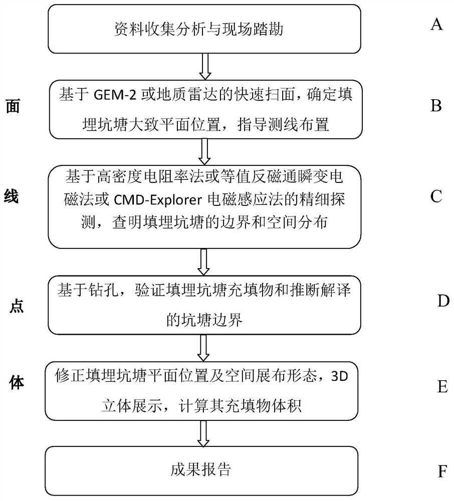
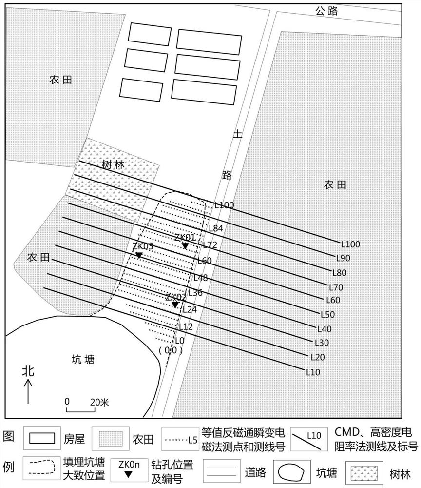
[0038] Such as figure 1 , figure 2 As shown, the economical, rapid and accurate detection method of the underground space distribution characteristics of the buried pit pond ...


PUM


Abstract

The invention relates to a method for economically, quickly and accurately detecting underground space distribution characteristics of a landfill pond. The method comprises the following steps: collecting and analyzing data, carrying out field survey, and carrying out geophysical exploration in a region with a resistivity difference; scanning the research area from the surface to delineate the range boundary of the landfill pond; depicting the position of the landfill pond and the underground space distribution from the line; carrying out drilling verification on the determined results of the plane position and the underground space distribution range of the landfill pond from points; and displaying the plane position and the underground space distribution range of the landfill pond from the body. According to the method for economically, quickly and accurately detecting the underground space distribution characteristics of the landfill pond, the equivalent anti-magnetic flux transient electromagnetic method, a geological radar, a high-density resistivity method, an electromagnetic induction method and drilling are applied to accurately detecting the plane position boundary and the space distribution range of the landfill pond for the first time, and rapid and accurate detection of the landfill pond is achieved; and detection cost is low, and popularization and application can be realized.

Description

technical field [0001] The invention relates to a method for filling pits and ponds. In particular, it relates to a method for economically, rapidly and accurately detecting the distribution characteristics of the underground space of the buried pit pond. Background technique [0002] The construction of a new type of city requires a more scientific and rational use of underground space resources. In order to avoid unfavorable geological bodies such as land subsidence, ground fissures, water-bearing sand layers, and pits (earth pits, ponds, and landfill pits) from adversely affecting urban planning projects such as ecological construction and construction engineering, it is necessary to quickly detect their distribution In order to adapt measures to local conditions and implement precise policies. For example, according to a report by People’s Daily Online on July 17, 2018, during the urban construction of Xiong’an New District, a total of 810 sewage pits and ponds were fo...

Claims


Application Information

Patent Timeline
IPC IPC(8): G01V3/38
CPCG01V3/38
Inventor 苏永军林良俊胡婷赵玉立曹占宁张宗庆韩博范翠松张国利
Owner 中国地质调查局天津地质调查中心
Learn More