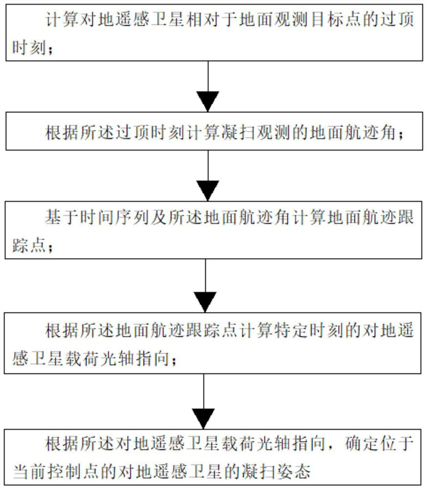
Method and system for controlling attitude of ground remote sensing satellite during sweeping and sweeping
A remote sensing satellite and attitude control technology, which is applied in the field of remote sensing satellites, can solve the problems of low attitude control accuracy of remote sensing satellites and affect the scanning accuracy, etc., achieve high-precision and distortion-free scanning observation control, improve imaging quality, and achieve the best imaging effect Effect
- Summary
- Abstract
- Description
- Claims
- Application Information
AI Technical Summary
Problems solved by technology
Method used
Image


Examples
Embodiment Construction
[0103] The method and system for controlling the sweeping attitude of the earth remote sensing satellite proposed by the present invention will be further described in detail below in conjunction with the accompanying drawings and specific embodiments. Advantages and features of the present invention will be apparent from the following description and claims. It should be noted that all the drawings are in a very simplified form and use imprecise scales, and are only used to facilitate and clearly assist the purpose of illustrating the embodiments of the present invention.
[0104] In addition, the numbers of the steps of the various methods of the present invention do not limit the execution sequence of the method steps. Unless otherwise indicated, the various method steps may be performed in a different order.
[0105] The core idea of the present invention is to provide a method and system for controlling the attitude of the ground remote sensing satellite, so as to solv...
PUM
 Abstract
Description
Claims
Application Information
 - R&D
- Intellectual Property
- Life Sciences
- Materials
- Tech Scout
- Unparalleled Data Quality
- Higher Quality Content
- 60% Fewer Hallucinations
Browse by: Latest US Patents, China's latest patents, Technical Efficacy Thesaurus, Application Domain, Technology Topic, Popular Technical Reports.
© 2025 PatSnap. All rights reserved.Legal|Privacy policy|Modern Slavery Act Transparency Statement|Sitemap|About US| Contact US: help@patsnap.com