Three-dimensional geographic information model rendering method and system based on generative adversarial network

A geographic information and 3D map technology, applied in biological neural network models, neural learning methods, 3D modeling, etc., can solve the problem of low rendering speed of 3D maps, and achieve the effect of improving rendering speed, rendering speed and expanding quantity.

Pending Publication Date: 2021-04-16
武汉青图科技工程有限公司
View PDF0 Cites 1 Cited by
  • Summary
  • Abstract
  • Description
  • Claims
  • Application Information

AI Technical Summary

Problems solved by technology

[0005] In view of this, the present invention proposes a fast rendering method, system, device, and storage medium of a 3D geographic information model based on a generative confrontation network, to solve the problem of low rendering speed of existing 3D maps

Method used


Image

  • Three-dimensional geographic information model rendering method and system based on generative adversarial network
  • Three-dimensional geographic information model rendering method and system based on generative adversarial network

Examples


Embodiment Construction

[0047] The following will clearly and completely describe the technical solutions in the embodiments of the present invention in conjunction with the embodiments of the present invention. Obviously, the described embodiments are only part of the embodiments of the present invention, not all of them. Based on the implementation manners in the present invention, all other implementation manners obtained by persons of ordinary skill in the art without making creative efforts belong to the scope of protection of the present invention.

[0048] In the embodiment of the present invention, the rendering device uses a computer with CPU i7, memory 16G, and video memory 8G. The operating system uses Ubuntu 16.04. The machine learning platform uses Tensorflow2.0. map.

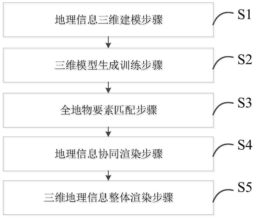
[0049] see figure 1 , the present invention proposes a three-dimensional geographic information model rendering method based on generative confrontation networks, the method comprising:

[0050] S1. The step of 3D model...


PUM


Abstract

The invention discloses a three-dimensional geographic information model rendering method and system based on a generative adversarial network, equipment and a storage medium. The method comprises a geographic information three-dimensional modeling step, a three-dimensional model generation training step, an all-terrain element matching step, a three-dimensional geographic information collaborative rendering step and a three-dimensional geographic information overall rendering step. Generation of the geographic information model is achieved through an artificial intelligence method and a generative adversarial network framework, all-terrain element matching and similar terrain theme part extraction are achieved through a sliding matching mode, non-repeated rendering of similar three-dimensional geographic information model main body parts is achieved through a mode of pre-rendering in a cache in advance, therefore, the rendering speed of the three-dimensional object is improved.

Description

technical field [0001] The invention belongs to the technical field of three-dimensional visualization of geographic information, and in particular relates to a fast rendering method, system, device and storage medium of a three-dimensional geographic information model based on a generative confrontation network. Background technique [0002] With the research and development of remote sensing technology and sensor technology, traditional two-dimensional maps have been gradually replaced by three-dimensional maps with more information and better visualization effects. [0003] At present, whether it is a vector map or an image map, two-dimensional maps can achieve efficient rendering on the basis of existing hardware performance and optimization algorithms, meeting the needs of real-time map display and use. [0004] For 3D maps, due to the large amount of data, and the traditional rendering method needs to render all points pixel by pixel, it often consumes a huge amount of...

Claims


Application Information

Patent Timeline
IPC IPC(8): G06T15/00G06T17/05G06N3/08
Inventor 樊静胡彩云张良
Owner 武汉青图科技工程有限公司
Why Eureka
Try Eureka