Robust intelligent cooperative calibration method for INS/DVL integrated navigation system

A technology for an integrated navigation system and a calibration method, which is applied to radio wave measurement systems, measurement devices, instruments, etc., and can solve problems such as difficulty in meeting requirements

Active Publication Date: 2021-03-19
HARBIN ENG UNIV
View PDF9 Cites 11 Cited by
  • Summary
  • Abstract
  • Description
  • Claims
  • Application Information

AI Technical Summary

Problems solved by technology

The existing HKF, MCKF and RSTKF are difficult to meet the requirements

Method used


Image

  • Robust intelligent cooperative calibration method for INS/DVL integrated navigation system
  • Robust intelligent cooperative calibration method for INS/DVL integrated navigation system
  • Robust intelligent cooperative calibration method for INS/DVL integrated navigation system

Examples


specific Embodiment approach

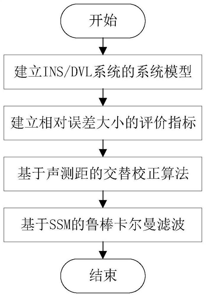
[0086] combine figure 1 , the specific embodiment of the present invention comprises the following steps:

[0087] Step 1: Establish a traditional INS / DVL system model including state equations and measurement equations;

[0088] Specific steps are as follows:

[0089] The first step is to establish the state equation of the system. To derive the error equation for an inertial navigation system, we define the following coordinate system. The carrier coordinate system of the inertial navigation system is expressed as b, the inertial coordinate system is expressed as i, the earth-centered ground-fixed coordinate system is expressed as e, the actual navigation coordinate system is expressed as n, and the calculated navigation coordinate system is expressed as n'. Select the northeast sky coordinate system as the navigation coordinate system n. The error model of the inertial navigation system can be obtained by derivation:

[0090]

[0091]

[0092]

[0093]

[0...


PUM


Abstract

The invention discloses a robust intelligent cooperative calibration method for an INS / DVL integrated navigation system. The method comprises the following steps: 1, establishing a traditional INS / DVLsystem model including a state equation and a measurement equation; 2, correcting the marine unmanned motion platform by adopting an alternate correction algorithm based on acoustic ranging; and 3, filtering an output abnormal value by using a robust Kalman filter based on statistical similarity measurement. The alternate correction algorithm based on underwater acoustic ranging does not need tobe supported by a reference station or a mother ship, so that the working range of the marine unmanned motion platform is expanded, and the positioning precision of the marine unmanned motion platformis further improved; and the calculated amount of the robust filter is smaller than that of an existing robust filter, the method has more advantages in navigation application with high sampling frequency, the robustness of a non-Gaussian scene caused by an abnormal value is higher than that of the existing robust filter, and the positioning precision of the method is superior to that of a traditional INS / DVL integrated navigation system.

Description

technical field [0001] The invention relates to a robust intelligent collaborative calibration method for an INS / DVL integrated navigation system, in particular to a robust intelligent collaborative calibration method for a navigator INS / DVL integrated navigation system based on acoustic ranging, and belongs to the technical field of navigation. Background technique [0002] With the deepening of ocean exploration, marine unmanned motion platforms play an important role in the fields of ocean development, ocean survey, and biological monitoring. Considering the cost of navigation equipment, marine unmanned motion platforms usually navigate in a cluster mode. Since the accuracy of the navigation equipment carried by the navigator and the auxiliary unmanned motion platform is different, the positioning accuracy of the navigation system and the positioning of the auxiliary unmanned motion platform Accuracy depends on the navigator's positioning accuracy. In order to improve th...

Claims


Application Information

Patent Timeline
Patent Type & Authority Applications(China)
IPC IPC(8): G01C25/00G01S7/52
CPCG01C25/005G01S7/52004
Inventor 徐博胡俊苗郭瑜赵玉新张广拓吴磊郑杰
Owner HARBIN ENG UNIV
Why Eureka
Try Eureka