Land property change analysis method

A change analysis, land technology, applied in structured data retrieval, geographic information database, special data processing applications, etc., can solve problems such as heavy workload, difficult data connection, and error-prone

Pending Publication Date: 2021-03-09
SHANGHAI RES INST OF BUILDING SCI CO LTD
View PDF0 Cites 0 Cited by
  • Summary
  • Abstract
  • Description
  • Claims
  • Application Information

AI Technical Summary

Problems solved by technology

High workload, error-prone and difficult to connect with spatial geographic data

Method used


Image

  • Land property change analysis method
  • Land property change analysis method
  • Land property change analysis method

Examples


Embodiment Construction

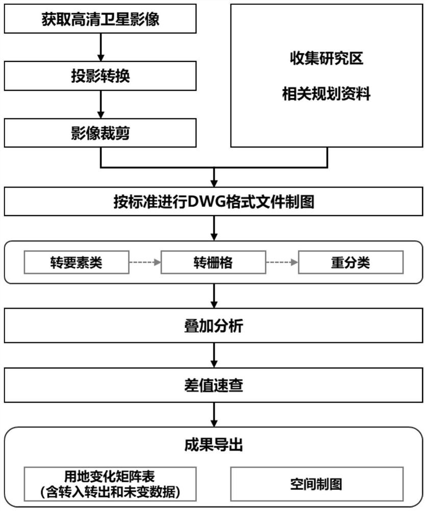
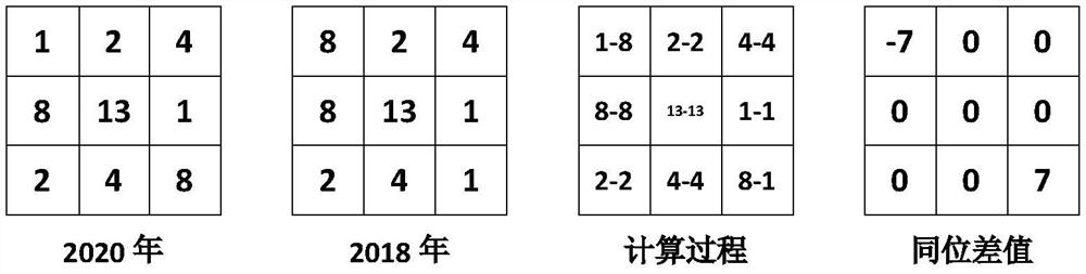
[0008] The invention is used to analyze the changes in the nature of construction land over the years, and diagnose future development trends; compare the differences between planning schemes and construction status, and judge the rationality of the schemes; analyze the differences in construction land among different schemes, and compare and select multiple schemes efficiently. At the same time, this invention is mainly aimed at urban planners, and provides solutions to the following three major problems: ①Propose a general method for analyzing changes in the nature of construction land to reduce the error of manual statistics; ②Deepen the traditional analysis mode to realize the spatial flow analysis of land use changes and transfers ;③Standardized data analysis matrix, which can be transplanted to multiple similar scenarios for analysis and application.

[0009] According to one or more implementation cases, a method for detecting spatial changes in urban construction land p...


PUM


Abstract

The invention relates to a land property change analysis method, and the method comprises the following steps: gridding land in a planning research range, assigning different numbers to different landproperty attributes, marking the land property of the grid land in each grid, generating a land property digital grid of the land in the planning research range, regarding the digital grid as a digital matrix reflecting the land property of the land grid; generating a plurality of digital matrixes at different time points according to the historical data of the land properties in the planning research range; calculating difference values of the different digital matrixes to form a difference value matrix; and judging the change trend of the land property according to the difference.

Description

technical field [0001] The invention belongs to the technical field of urban and rural planning, in particular to a method for analyzing changes in land properties. Background technique [0002] With the ever-changing urban system, urban problems continue to emerge. Studying the spatial changes and trends of cities is an important way to discover and solve urban problems. The most important sign of urban space expansion is the expansion of urban construction land. In the context of the new round of land and space planning, analyzing changes in the nature of land use is also an important method to test the rationality of space planning. [0003] At present, most urban planners use CAD software to assist and use manual calculations for analysis. A lot of work, error-prone and difficult to connect with spatial geographic data. Contents of the invention [0004] According to one of the embodiments of the present invention, a method for analyzing changes in land properties...

Claims


Application Information

Patent Timeline
IPC IPC(8): G06F17/16G06F16/29
CPCG06F17/16G06F16/29
Inventor 张颖汤鹏孙桦潘洪艳孙明明叶剑军吕杰
Owner SHANGHAI RES INST OF BUILDING SCI CO LTD
Why Eureka
Try Eureka