Unmanned aerial vehicle image and satellite remote sensing image fusion algorithm

A technology of satellite remote sensing image and fusion algorithm, which is applied in the field of fusion algorithm of UAV image and satellite remote sensing image, to achieve the effects of preventing filling insufficiency, preventing image distortion, and enhancing recognition and classification accuracy

Pending Publication Date: 2021-02-05
黑龙江省网络空间研究中心
View PDF0 Cites 4 Cited by
  • Summary
  • Abstract
  • Description
  • Claims
  • Application Information

AI Technical Summary

Problems solved by technology

[0006] The purpose of the present invention is to provide a kind of unmanned aerial vehicle image and satellite remote sensing image fusion algorithm, to solve the problem on the current market that the above-mentioned background technology proposes

Method used


Image

  • Unmanned aerial vehicle image and satellite remote sensing image fusion algorithm
  • Unmanned aerial vehicle image and satellite remote sensing image fusion algorithm
  • Unmanned aerial vehicle image and satellite remote sensing image fusion algorithm

Examples


Embodiment Construction

[0018] The following will clearly and completely describe the technical solutions in the embodiments of the present invention with reference to the accompanying drawings in the embodiments of the present invention. Obviously, the described embodiments are only some, not all, embodiments of the present invention. Based on the embodiments of the present invention, all other embodiments obtained by persons of ordinary skill in the art without making creative efforts belong to the protection scope of the present invention.

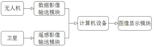
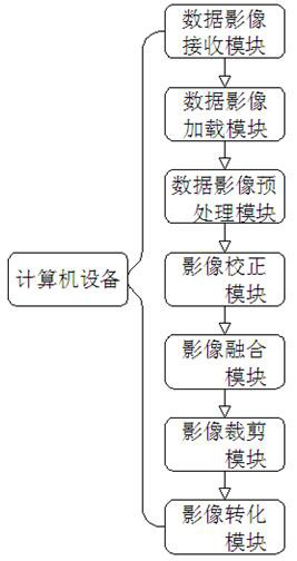
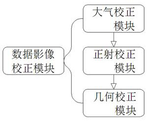
[0019] see Figure 1-3 , the present invention provides a technical solution: a fusion algorithm of UAV image and satellite remote sensing image, including UAV, data image transmission module, satellite, remote sensing image transmission module, computer equipment and image display module, UAV The output end is connected to the input end of the data image transmission module, and the output end of the data image transmission module is connected to the input en...


PUM


Abstract

The invention discloses an unmanned aerial vehicle image and satellite remote sensing image fusion algorithm, which comprises an unmanned aerial vehicle, a data image transmission module, a satellite,a remote sensing image transmission module, computer equipment and an image display module; the output terminal of the unmanned aerial vehicle is connected with the input terminal of the data image transmission module; the output terminal of the data image transmission module is connected with the input terminal of computer equipment, the input terminal of the computer equipment is connected withthe output terminal of the remote sensing image transmission module, and the input terminal of the remote sensing image transmission module is connected with the output terminal of a satellite. And the output terminal of the computer equipment is connected with the input terminal of the image display module. According to the unmanned aerial vehicle image and satellite remote sensing image fusionalgorithm, the unmanned aerial vehicle image and the satellite remote sensing image can be stably corrected and calibrated by using an atmospheric correction module, an orthographic correction moduleand a geometric correction module so that the sense of reality of the original image can be reserved and image distortion can be prevented.

Description

technical field [0001] The invention relates to the technical field of image fusion, in particular to an algorithm for fusion of drone images and satellite remote sensing images. Background technique [0002] With the continuous development of science and technology, UAV-related technologies are developing rapidly. UAV systems have a wide variety of uses and distinctive features. Among them, in order to improve the accuracy and convenience of satellite earth observation work, it is necessary to combine the use of UAV aerial survey After working, the UAV can realize the collection of high-resolution images. While making up for the shortcomings of satellite remote sensing that often cannot obtain images due to cloud cover, it also solves the traditional satellite remote sensing. The images acquired by drones have the advantages of high resolution, obvious image details, and rich visual areas, while high-resolution satellite remote sensing images have the advantages of large ac...

Claims


Application Information

Patent Timeline
Patent Type & Authority Applications(China)
IPC IPC(8): G06T5/50G06T5/00G06K9/62G06T7/174
CPCG06T5/50G06T5/006G06T7/174G06T2207/10032G06T2207/20132G06T2207/20221G06T2207/30192G06F18/253
Inventor 谷俊涛曲家兴周莹孙恕杨霄璇吴琼
Owner 黑龙江省网络空间研究中心
Why Eureka
Try Eureka