


Quick Research
Generate reliable direction feasibility study reports for your R&D in just a few steps.

Technical Q&A
Discover and master advanced knowledge NOW. Basics, ideas, possibilities, all at once.

Find Solutions
As an expert in R&D theories, this can generate solutions to your technical problems instantly.

Evaluate Feasibility
Analyze your overall solution with one click, know your potential R&D risks in advance.

Monitor Landscape
Get weekly tech updates, stay abreast of the latest tech innovations and key insights.
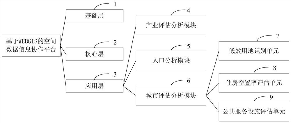
WEBGIS-based spatial data information collaboration platform and construction method thereof
A technology of spatial data and basic space, applied in the field of cloud computing, can solve the problems of lack of information collaboration platform, inability to empower big data, and difficulty in transformation of traditional industries.
- Summary
- Abstract
- Description
- Claims
- Application Information
AI Technical Summary
Problems solved by technology
Method used
Image


Examples
Embodiment 1
[0070] Such as figure 2 As shown, the steps to evaluate public service facilities based on the urban night scene lighting analysis data are as follows:
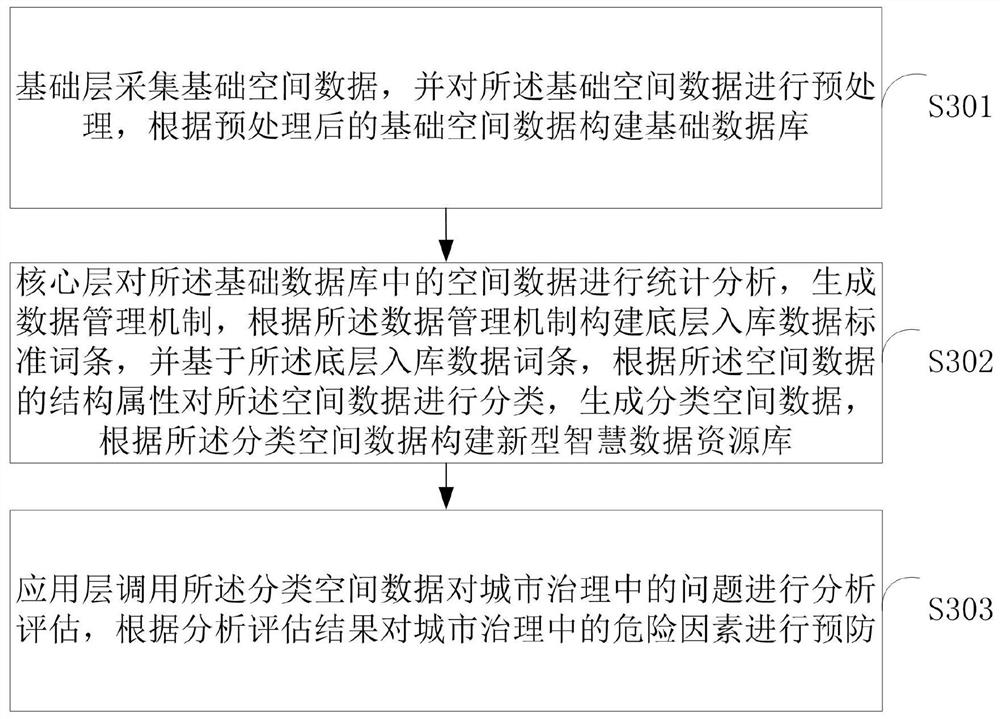
[0071] The base layer 1 collects the vector files of the administrative divisions of Shandong Province, the vector files of the municipal districts of Shandong Province, and the night light data of the municipal districts of Shandong Province, and queries the urban construction land area data in the "China City Statistical Yearbook", and obtains the data from the vector files of the administrative divisions of Shandong Province. Extract night light tube data and correct the night light data;
[0072]The core layer 2 extracts the night light data of Shandong Province from the night light data according to the standard entries of the underlying data, and sets the projection for the night light data of Shandong Province. The threshold value of night light data is determined in the urban construction land area data of the "Chin...
PUM
 Abstract
Description
Claims
Application Information
 - R&D Engineer
- R&D Manager
- IP Professional
- Industry Leading Data Capabilities
- Powerful AI technology
- Patent DNA Extraction
Browse by: Latest US Patents, China's latest patents, Technical Efficacy Thesaurus, Application Domain, Technology Topic, Popular Technical Reports.
© 2024 PatSnap. All rights reserved.Legal|Privacy policy|Modern Slavery Act Transparency Statement|Sitemap|About US| Contact US: help@patsnap.com