
Urban heat island intensity quantification method and system, storage medium and equipment

An urban heat island and quantitative method technology, applied in the field of urban environmental analysis, can solve the problems of overestimating the urban heat island, city size, development model constraints, underestimating the intensity of the urban heat island, etc., to achieve the effect of wide application range and accurate quantitative results

Pending Publication Date: 2021-01-05
HUAZHONG AGRI UNIV
View PDF0 Cites 5 Cited by
  • Summary
  • Abstract
  • Description
  • Claims
  • Application Information

AI Technical Summary

Problems solved by technology

However, these methods have various limitations
First, the study shows that the city-water body temperature differential approach is only effective in the presence of large water bodies, and other methods have similar limitations
Secondly, the LST of water body, cultivated land, other areas, and woodland is closely related to the surrounding natural environment. The local LST will be affected by the intensity of the surrounding LST, and there are significant seasonal changes in plant activities such as woodland and cultivated land. Plant leaves in spring and autumn It has not yet fully expanded or has withered, so the above methods may have problems such as underestimating the urban heat island intensity in spring, summer, and autumn, and overestimating the urban heat island in winter.
Finally, the application of the average-fixed threshold method is also greatly limited due to its heterogeneity in city size, development mode, etc.

Method used


Image

  • Urban heat island intensity quantification method and system, storage medium and equipment
  • Urban heat island intensity quantification method and system, storage medium and equipment
  • Urban heat island intensity quantification method and system, storage medium and equipment

Examples


Embodiment Construction

[0065]The principles and features of the present invention will be described below with reference to the accompanying drawings. The examples cited are only used to explain the present invention, and are not used to limit the scope of the present invention.

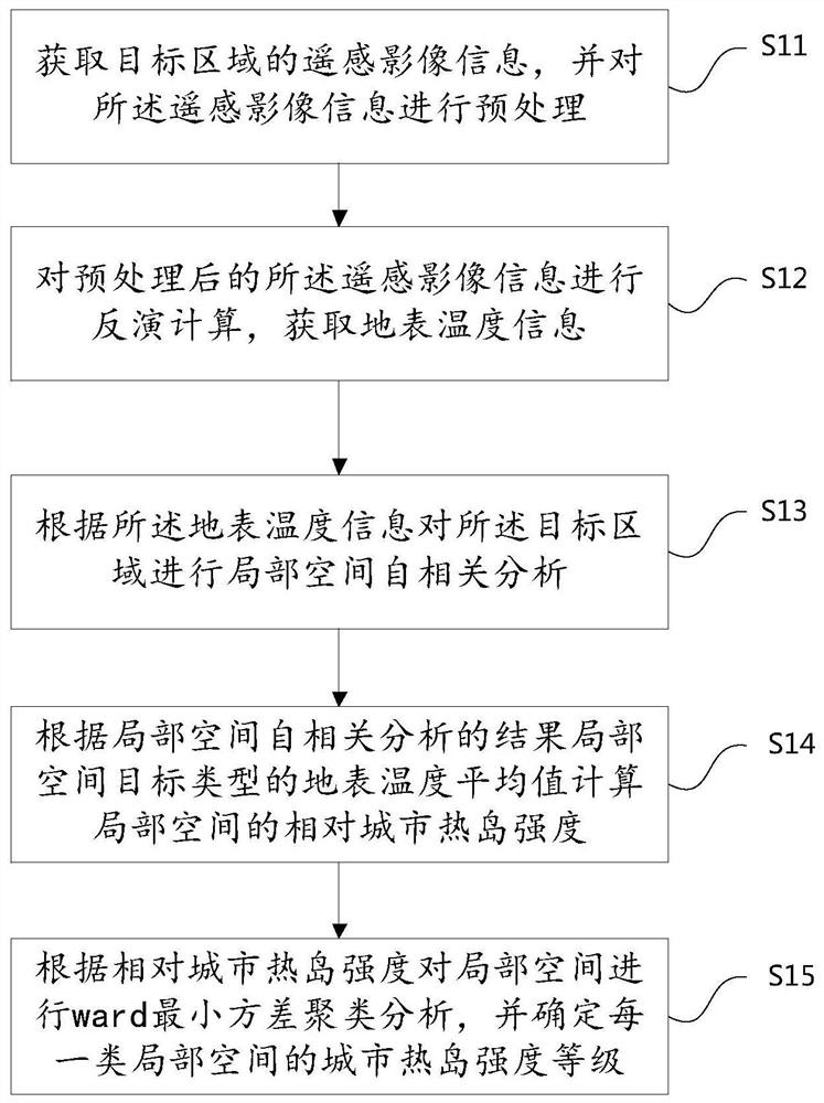
[0066]Such asfigure 1 As shown, a method for quantifying the intensity of urban heat islands includes the following steps:

[0067]S11: Obtain remote sensing image information of the target area, and preprocess the remote sensing image information;

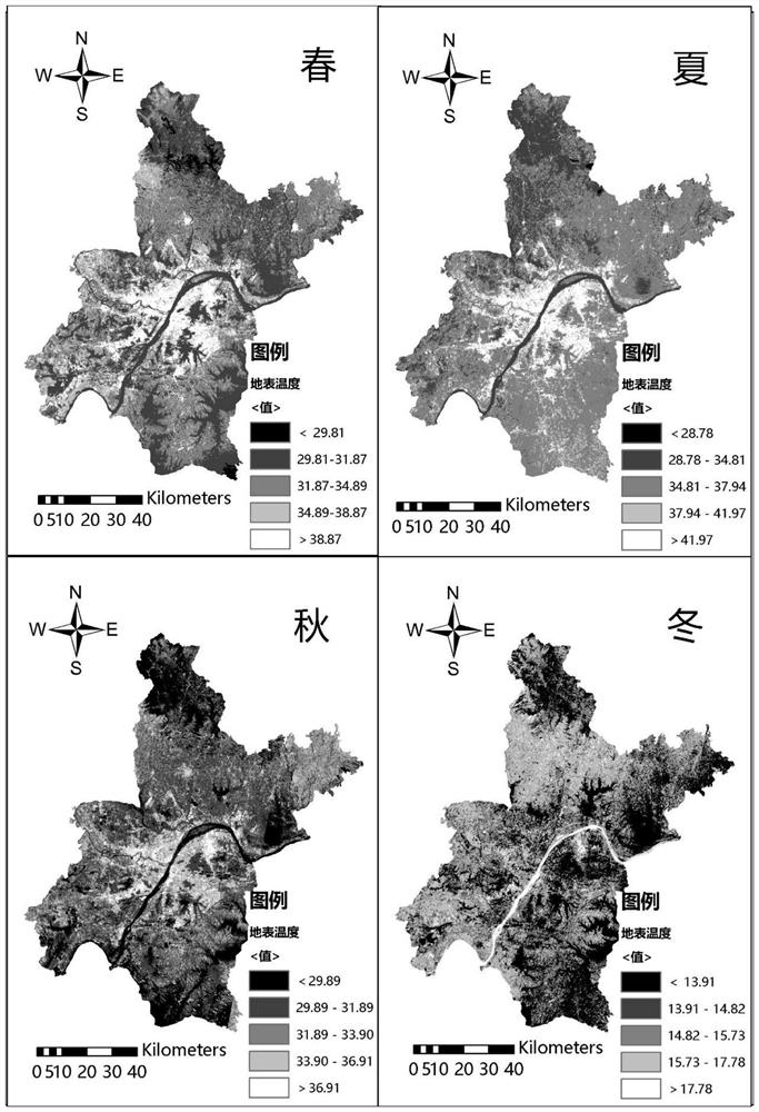
[0068]S12: Perform inversion calculation on the preprocessed remote sensing image information to obtain land surface temperature information;

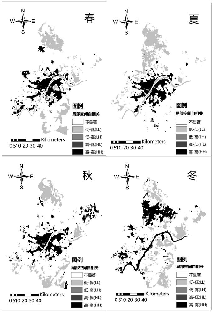
[0069]S13: Perform local spatial autocorrelation analysis on the target area according to the land surface temperature information;

[0070]S14: Calculate the relative urban heat island intensity of the local space according to the results of the local spatial autocorrelation analysis;

[0071]S15: Perform ward minimum variance cluster analysis on the local s...


PUM


Abstract

The invention relates to an urban heat island intensity quantification method and system, a storage medium and equipment. The method comprises the following steps: acquiring and preprocessing remote sensing image information of a target area; performing inversion calculation on the preprocessed remote sensing image information to obtain surface temperature information; performing local space autocorrelation analysis on the target area according to the surface temperature information; and calculating the relative urban heat island strength of the local space and carrying out ward minimum variance clustering analysis to determine the urban heat island strength grade of the local space. According to the invention, the remote sensing image is subjected to preprocessing and inversion calculation to obtain the surface temperature information, and local space autocorrelation analysis is carried out to obtain the average value of the surface temperature information of the target type of the local space, so that the relative urban heat island intensity and urban heat island intensity level of the local space are accurately calculated; the problems that an existing method is difficult to ignore, application limitation is caused, and the surface temperature is affected by the surrounding environment are greatly solved, the quantification result is accurate, and the application range is wider.

Description

Technical field[0001]The present invention relates to the technical field of urban environment analysis, in particular to a method, system, storage medium and equipment for quantifying the intensity of urban heat islands.Background technique[0002]With the continuous advancement of global urbanization, the transformation of urban natural landscapes into impervious surfaces has caused a series of environmental problems. Urban heat island is one of the most typical environmental problems. It refers to a phenomenon in which the temperature in the urban area is higher than that in the suburbs. It exacerbates extreme weather events, increases energy consumption, endangers the health of residents, increases heat-related mortality, and worsens The air quality and so on.[0003]Indicators calculated based on remote sensing data are often used to quantify the intensity of urban heat islands. The classic method is to quantify the temperature difference between cities and suburbs. However, the am...

Claims


Application Information

Patent Timeline
IPC IPC(8): G06K9/00G06K9/62G06N20/20
CPCG06N20/20G06V20/13G06F18/23G06F18/214Y02A30/60
Inventor 周志翔向炀汪小爽滕明君佃袁勇徐永荣王鹏程
Owner HUAZHONG AGRI UNIV
Learn More