
Watershed similarity discrimination method based on watershed attribute distance

A discrimination method and watershed technology, applied in character and pattern recognition, image data processing, instruments, etc., can solve the problems of lack of watershed attribute optimization system, great subjective arbitrariness, low efficiency, etc., to achieve stable and reliable data sources, guaranteeing The effect of objective rationality

Active Publication Date: 2020-11-24
POWERCHINA CHENGDU ENG +1
View PDF20 Cites 8 Cited by
  • Summary
  • Abstract
  • Description
  • Claims
  • Application Information

AI Technical Summary

Problems solved by technology

[0006] (1) The selection of watershed attribute factors usually relies on the subjective experience of researchers for qualitative analysis and selection, artificially selecting one or several elements (such as topography, landform, soil, vegetation, etc.) as watershed attributes, lacking a complete set of watershed attributes Optimum system, there is a lot of subjective arbitrariness and low efficiency
[0007] (2) "Euclidean distance" (that is, Euclidean measure) is often used to describe the distance between two or more watersheds, which is often ineffective in measuring the distance between nested watersheds, especially Nested watersheds with large differences in upstream and downstream watershed attributes
[0008] (3) In practice, the classification of the similarity degree in the watershed similarity judgment is not completely consistent, and most of them take fixed values ​​based on the experience of researchers, and there is a certain degree of uncertainty

Method used


Image

  • Watershed similarity discrimination method based on watershed attribute distance
  • Watershed similarity discrimination method based on watershed attribute distance
  • Watershed similarity discrimination method based on watershed attribute distance

Examples


Embodiment Construction

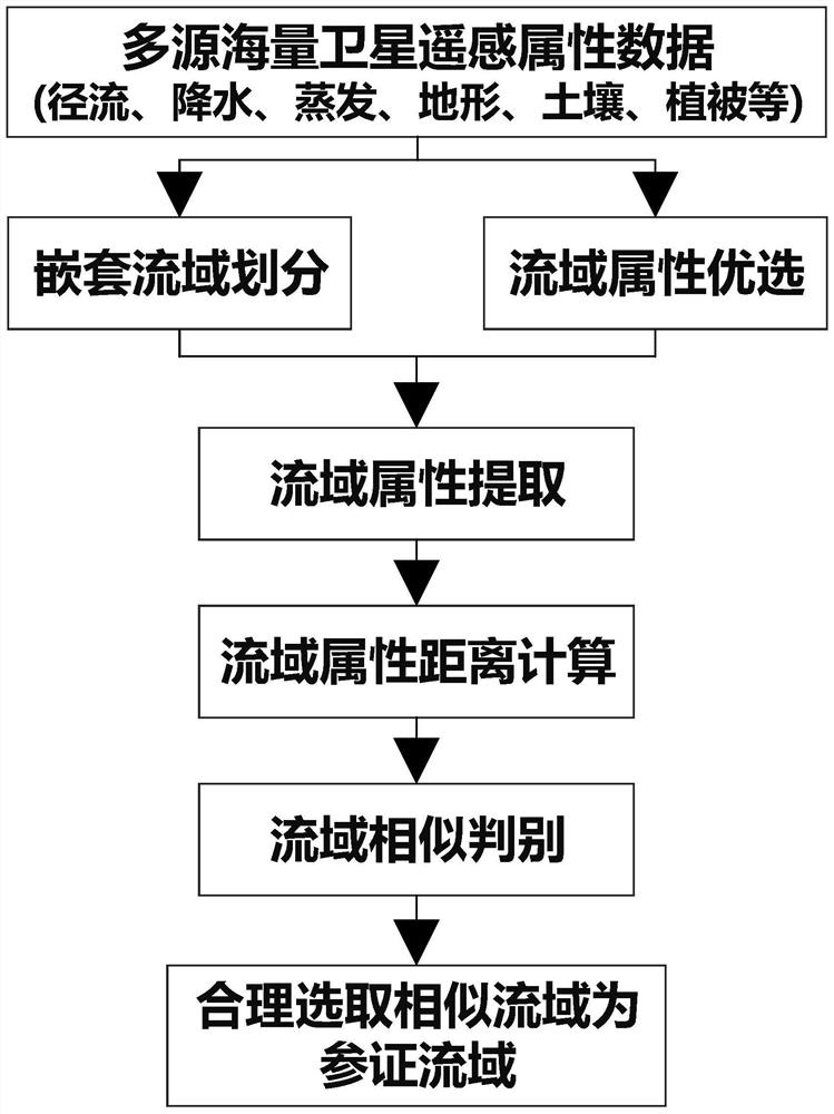
[0064] The invention aims at proposing a watershed similarity judgment method based on the watershed attribute distance, so as to improve the comprehensiveness, objectivity and rationality of the reference watershed selection. Its core idea is: based on high-resolution precipitation, evaporation, topography, soil, vegetation and other multi-source massive satellite remote sensing attribute raster data, nested watershed division and watershed attribute selection are carried out; according to the mask layer of each nested watershed , extract the satellite remote sensing attribute raster data of each nested watershed; and propose a new "generalized distance" that can comprehensively reflect the watershed attribute factors and the nested structure of the watershed, and calculate the watershed attribute distance of each nested watershed; based on the watershed attribute Calculate the watershed similarity of each nested watershed by distance, and judge the watershed similarity accord...


PUM


Abstract

The invention relates to a hydrological analysis technology in water conservancy and hydropower engineering, and discloses a watershed similarity discrimination method based on watershed attribute distance to improve comprehensiveness, objectivity and rationality of reference watershed selection. The method comprises the following steps: firstly, performing nested watershed division and watershedattribute optimization based on high-resolution multi-source massive satellite remote sensing attribute raster data; secondly, extracting attribute raster data of each nested watershed according to the mask layer of each nested watershed; calculating a basin attribute distance of each nested basin through a generalized distance capable of comprehensively reflecting a basin attribute factor and a basin nested structure; and finally, calculating the basin similarity of each nested basin based on the basin attribute distance, and performing basin similarity judgment according to similarity grading. According to the method, the accuracy and accuracy of basin similarity judgment are effectively improved, important technical support is provided for reasonably selecting the reference basin in hydrological analysis of water conservancy and hydropower engineering in regions lack of data, and the selection of the reference basin is more comprehensive, objective and reasonable.

Description

technical field [0001] The invention relates to hydrological analysis technology in water conservancy and hydropower engineering, in particular to a watershed similarity discrimination method based on watershed attribute distance. Background technique [0002] Basic hydrological data are the basis of hydrological analysis and calculation of water conservancy and hydropower projects, and their importance is self-evident. Today, the overall development of water conservancy and hydropower in the basin is showing a development trend from areas with data to areas without data; and the local area often lacks long series of hydrological data that can meet the requirements of the "Code for Hydrological Calculation of Water Conservancy and Hydropower Engineering (SL 278-2002)" (the length of the series should be within over 30 years). Therefore, the shortage or scarcity of basic hydrological data is a common problem faced by hydrological analysis and calculation of water conservancy...

Claims


Application Information

Patent Timeline
IPC IPC(8): G06K9/00G06K9/62G06T7/62
CPCG06T7/62G06V20/182G06F18/22Y02A10/40
Inventor 康有杨百银夏传清马良马顺刚顾洪宾张军良
Owner POWERCHINA CHENGDU ENG
Learn More