Power transmission line satellite remote sensing image fusion method and device

A satellite remote sensing image and satellite remote sensing technology, applied in the field of remote sensing data fusion, can solve the problem of destroying the spatial structure of the image, achieve the effect of multi-spatial texture features and reduce information distortion

Pending Publication Date: 2020-11-17
CHINA ELECTRIC POWER RES INST +2
View PDF0 Cites 0 Cited by
  • Summary
  • Abstract
  • Description
  • Claims
  • Application Information

AI Technical Summary

Problems solved by technology

[0010] 2) The divided blocks destroy the entire spatial structure of the image
However, there is a strong correlation and similarity between the MS image bands

Method used


Image

  • Power transmission line satellite remote sensing image fusion method and device
  • Power transmission line satellite remote sensing image fusion method and device
  • Power transmission line satellite remote sensing image fusion method and device

Examples


Embodiment Construction

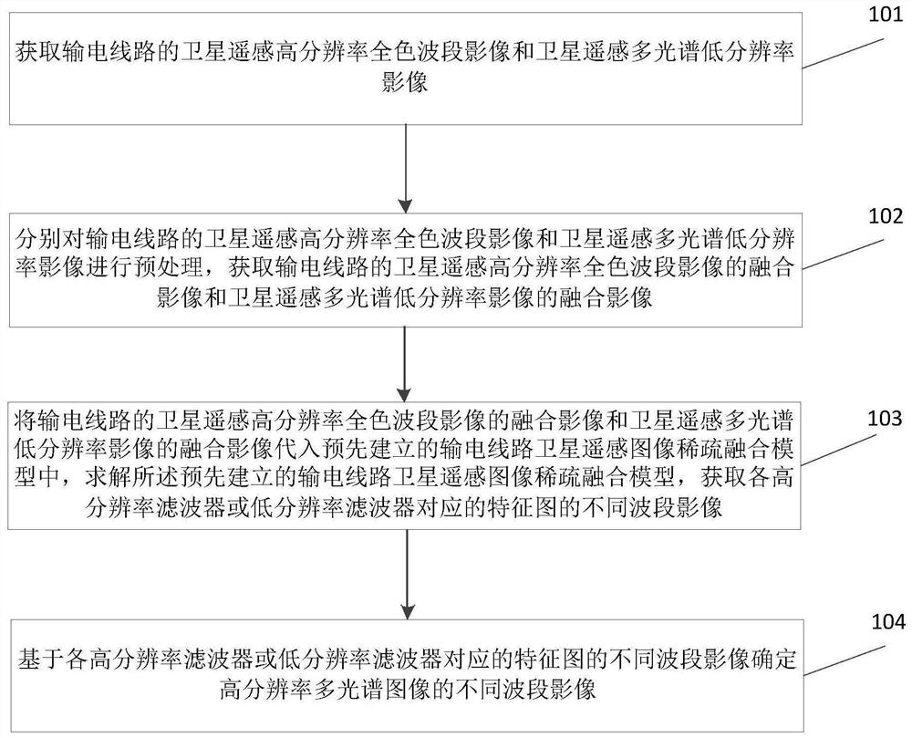
[0055] The specific implementation manners of the present invention will be further described in detail below in conjunction with the accompanying drawings.

[0056] In order to make the purpose, technical solutions and advantages of the embodiments of the present invention clearer, the technical solutions in the embodiments of the present invention will be clearly and completely described below in conjunction with the drawings in the embodiments of the present invention. Obviously, the described embodiments It is a part of embodiments of the present invention, but not all embodiments. Based on the embodiments of the present invention, all other embodiments obtained by persons of ordinary skill in the art without making creative efforts belong to the protection scope of the present invention.

[0057] The transmission line is a strip-shaped continuous ground object, and the hollow structure characteristics of the transmission tower and the texture characteristics of the metal ...


PUM


Abstract

The invention relates to a power transmission line satellite remote sensing image fusion method and device. The method comprises the following steps: obtaining a fusion image of a satellite remote sensing high-resolution panchromatic band image and a fusion image of a satellite remote sensing multispectral low-resolution image of a power transmission line; substituting the fused image of the satellite remote sensing high-resolution panchromatic band image and the fused image of the satellite remote sensing multispectral low-resolution image of the power transmission line into a pre-establishedpower transmission line satellite remote sensing image sparse fusion model, and obtaining different band images of the feature map corresponding to each high-resolution filter or each low-resolutionfilter; determining different waveband images of the high-resolution multispectral image based on the different waveband images of the feature map corresponding to each high-resolution filter or eachlow-resolution filter. According to the scheme, a proper regularizer capable of capturing structure correlation is provided by considering correlation in a multispectral image frequency band, the fusion speed is increased, and reliable data guarantee is provided for subsequent inspection of environmental hidden dangers of a satellite remote sensing channel of a power transmission line.

Description

technical field [0001] The invention relates to the field of remote sensing data fusion, in particular to a satellite remote sensing image fusion method and device for power transmission lines. Background technique [0002] In recent years, the spatial resolution and update frequency of satellite remote sensing have become higher and higher, and they have been gradually and widely used in transmission line body inspection and channel inspection. In practical applications, transmission lines are weak targets in satellite remote sensing images, and their information needs to be enhanced to achieve high-precision inspections. [0003] Usually, high spatial resolution (HR) panchromatic satellite remote sensing imagery (PAN) with a single broadband channel contains accurate spatial details, while low spatial resolution (LR) multispectral satellite remote sensing imagery (MS) due to the difference in spatial and spectral resolution Physical compromises can provide more spectral p...

Claims


Application Information

Patent Timeline
Patent Type & Authority Applications(China)
IPC IPC(8): G06T5/50G06T5/00G06T3/40
CPCG06T3/4053G06T5/002G06T5/50G06T2207/10036G06T2207/10041G06T2207/20192
Inventor 杨知费香泽马潇赵斌滨刘虎贺新房
Owner CHINA ELECTRIC POWER RES INST
Why Eureka
Try Eureka