Unmanned aerial vehicle aerial survey control point arrangement and identification method and system

A UAV and control point technology, applied in the field of UAV aerial survey, can solve the problems of low UAV photogrammetry accuracy and unreasonable layout of control points during UAV aerial survey, so as to avoid recognition failure and reduce workload , Guaranteed quality effect

Inactive Publication Date: 2020-09-18
XIAN AERONAUTICAL POLYTECHNIC INST
View PDF10 Cites 2 Cited by
  • Summary
  • Abstract
  • Description
  • Claims
  • Application Information

AI Technical Summary

Problems solved by technology

[0004] The purpose of the present invention is to overcome the disadvantages of unreasonable arrangement of control points and low precision of UAV photogrammetry in the prior art, and provide a method and system for arrangement and recognition of control points of UAV aerial survey

Method used


Image

  • Unmanned aerial vehicle aerial survey control point arrangement and identification method and system
  • Unmanned aerial vehicle aerial survey control point arrangement and identification method and system

Examples


Embodiment Construction

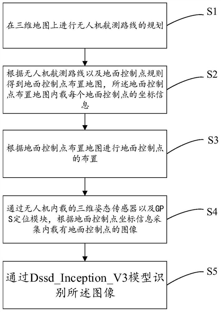
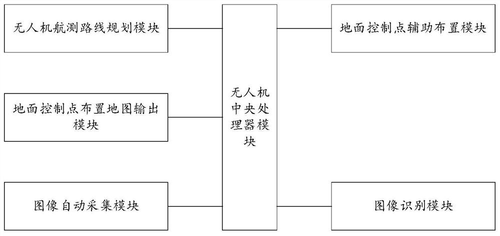
[0034] In order to enable those skilled in the art to better understand the solutions of the present invention, the following will clearly and completely describe the technical solutions in the embodiments of the present invention in conjunction with the drawings in the embodiments of the present invention. Obviously, the described embodiments are only It is an embodiment of a part of the present invention, but not all embodiments. Based on the embodiments of the present invention, all other embodiments obtained by persons of ordinary skill in the art without making creative efforts shall fall within the protection scope of the present invention.

[0035] It should be noted that the terms "first" and "second" in the description and claims of the present invention and the above drawings are used to distinguish similar objects, but not necessarily used to describe a specific sequence or sequence. It is to be understood that the data so used are interchangeable under appropriate ...


PUM


Abstract

The invention belongs to the field of unmanned aerial vehicle aerial survey, and discloses an unmanned aerial vehicle aerial survey control point arrangement and identification method and system. Themethod comprises the following steps: S1, carrying out the planning of an aerial survey route of an unmanned aerial vehicle on a three-dimensional map; S2, obtaining a ground control point arrangementmap according to the aerial survey route of the unmanned aerial vehicle and a ground control point rule, wherein coordinate information of each ground control point is loaded in the ground control point arrangement map; S3, arranging ground control points according to the ground control point arrangement map; S4, collecting an image internally loaded with the ground control points according to the coordinate information of the ground control points through a three-dimensional attitude sensor and a GPS positioning module which are internally loaded in the unmanned aerial vehicle; and S5, identifying the image through a Dssd_Inception_V3 model. According to the invention, reasonable arrangement of control points and automatic acquisition and identification of images of the control points can be realized, so that a guarantee is provided for smooth aerial survey of the unmanned aerial vehicle.

Description

technical field [0001] The invention belongs to the field of drone aerial survey, and relates to a method and system for arranging and identifying control points of drone aerial survey. Background technique [0002] UAV aerial survey is a powerful supplement to traditional aerial photogrammetry. It has the characteristics of flexible maneuverability, high efficiency and speed, precision and accuracy, low operating cost, wide application range, and short production cycle. It has obvious advantages in acquisition and is widely used in land and resources monitoring and other fields. However, with the continuous deepening of related research and application fields, higher requirements are put forward for the accuracy of UAV aerial survey data, especially in the field of aerial survey. A certain number of control points are arranged in the drone flight area, and the control points are identified to calibrate the drone aerial survey data and improve the accuracy of the drone photo...

Claims


Application Information

Patent Timeline
Patent Type & Authority Applications(China)
IPC IPC(8): G01C11/02G01C11/00G01C21/16G01S19/42G01C21/20
CPCG01C11/02G01C11/00G01C21/165G01S19/42G01C21/20
Inventor 田方王朋飞史佳豪赵莲莲李昊燔
Owner XIAN AERONAUTICAL POLYTECHNIC INST
Why Eureka
Try Eureka