Rural garbage collection and transportation management system based on geographic positioning information
A technology of positioning information and geolocation, applied in data processing applications, instruments, computing, etc., can solve the problems of insufficient supervision of garbage site removal and transportation, and achieve the effect of facilitating supervision
- Summary
- Abstract
- Description
- Claims
- Application Information
AI Technical Summary
Problems solved by technology
Method used
Image
Examples
Embodiment 1
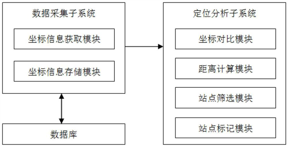
[0030] Rural garbage collection and transportation management system based on geographic location information, such as figure 1 Shown, including data acquisition subsystem, location analysis subsystem and database. The database pre-stores historical location information and site information of each garbage site. The historical location information refers to the location information uploaded before the current location information uploaded by the vehicle, and is stored in the order of uploading. The site information refers to information related to each garbage site, such as the location coordinates of each garbage site.
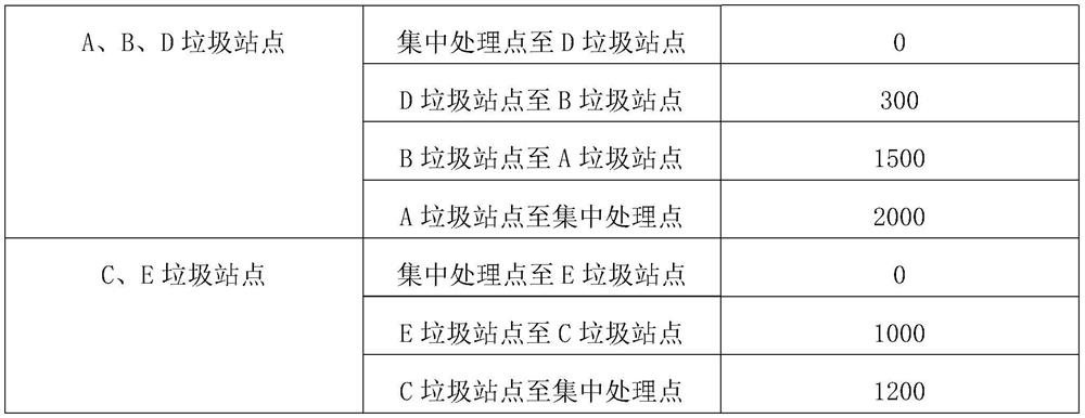
[0031] The data acquisition subsystem includes a coordinate information acquisition module and a coordinate information storage module. The coordinate information acquisition module is used to receive the current location information of the vehicle in real time, and is also used to obtain the site information from the database, and obtain the last location i...
Embodiment 2
[0035] The difference between this embodiment and Embodiment 1 is: the rural garbage collection and transportation management system based on geographic positioning information, the data acquisition subsystem also includes a sign-in acquisition module, and the sign-in acquisition module is used to receive active sign-in information, and the active sign-in information includes sign-in coordinates, and send the check-in coordinates to the positioning analysis subsystem. The active check-in information is the relevant information uploaded by the staff of the vehicle after arriving at the garbage site, including the coordinate information of the staff's location. The staff can upload the active check-in information through the smart phone.
[0036] In the positioning analysis subsystem, the distance calculation module is also used to calculate multiple check-in distances according to the check-in coordinates and the site information of each garbage site, and send the check-in dista...
Embodiment 3
[0038] The rural garbage collection and transportation management system based on geographic location information also includes a periodic accounting subsystem, and the periodic accounting subsystem includes a regular timing module, a statistical calculation module and a mark removal module.
[0039] The regular timing module is preset with a timing duration, which can be set according to requirements. In this embodiment, the timing duration is 168 hours, and the regular timing module is used to re-timing when the timing reaches the timing duration.
[0040] The statistical calculation module is used to count the number of garbage sites according to the site information when the timing of the regular timing module reaches the fixed time, and count the number of marked garbage sites, and generate garbage removal coverage according to the number of sites and the number of markers. In other embodiments, when the statistical calculation module counts the marked quantity of the mark...
PUM
 Abstract
Description
Claims
Application Information
 - R&D
- Intellectual Property
- Life Sciences
- Materials
- Tech Scout
- Unparalleled Data Quality
- Higher Quality Content
- 60% Fewer Hallucinations
Browse by: Latest US Patents, China's latest patents, Technical Efficacy Thesaurus, Application Domain, Technology Topic, Popular Technical Reports.
© 2025 PatSnap. All rights reserved.Legal|Privacy policy|Modern Slavery Act Transparency Statement|Sitemap|About US| Contact US: help@patsnap.com


