Eureka AIR delivers breakthrough ideas for toughest innovation challenges, trusted by R&D personnel around the world.

Cooperative vehicle positioning method based on fusion of GPS and vehicle ranging information

A technology of distance measurement information fusion and vehicle positioning, applied in the field of collaborative vehicle positioning, to meet the effect of timeliness requirements

Active Publication Date: 2020-11-10
SOUTHWEST UNIVERSITY FOR NATIONALITIES
View PDF5 Cites 0 Cited by
  • Summary
  • Abstract
  • Description
  • Claims
  • Application Information

AI Technical Summary

Problems solved by technology

[0012] The present invention provides a collaborative vehicle positioning method based on the fusion of GPS and vehicle-mounted distance measurement information that solves the defects of the above-mentioned existing SDR method

Method used


Image

  • Cooperative vehicle positioning method based on fusion of GPS and vehicle ranging information
  • Cooperative vehicle positioning method based on fusion of GPS and vehicle ranging information
  • Cooperative vehicle positioning method based on fusion of GPS and vehicle ranging information

Examples


Embodiment 1

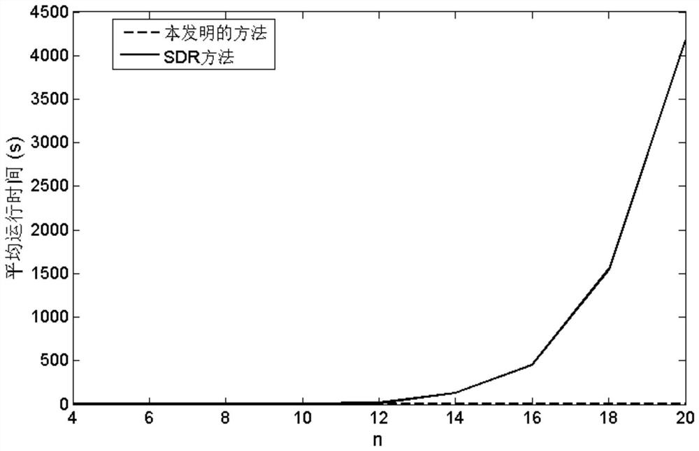
[0069] Example 1: Assuming the covariance parameter σ of GPS observation information i =5(i=1,...,n), the covariance parameter σ of the observation information of the vehicle ranging sensor ij =3 (1≤i≠j≤n). figure 2 The average running time of the method of the present invention and the SDR method on a personal computer (Intel(R) Core(TM) i7-6700CPU 3.40GHz, memory 8GB) was compared when the number of vehicles n gradually increased from 4 to 20. It can be seen that both methods can calculate quickly when the number of vehicles is small (n≤12). However, as the number of vehicles increases, the calculation time required by the SDR method increases rapidly, but the method of the present invention can still calculate quickly. In particular, when the number of vehicles is n=20, the average running time of the SDR method is 4168 seconds, while the method of the present invention is only 1.3 seconds.

Embodiment 2

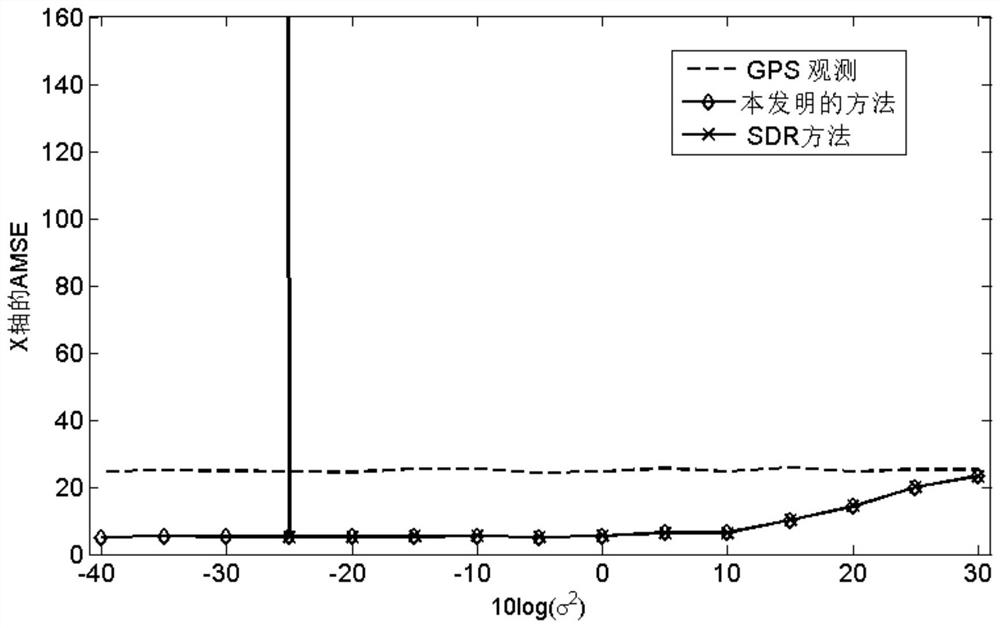
[0070] Example 2: Assuming the covariance parameter σ of GPS observation information i =5(i=1,...,n), the covariance parameter of the observation information of the vehicle ranging sensor image 3 with Figure 4 compared the σ 2 Gradually increasing from -40dB to 30dB, the average mean square error (average MSE, AMSE) of the method of the present invention and the SDR method on the X-axis and Y-axis. It can be seen that the SDR method in σ 2 smaller (σ 2 ≤-25dB), there will be divergence, that is, the positioning error of the fusion of GPS and vehicle ranging information is higher than the positioning error of GPS observation. The method of the present invention can effectively improve the accuracy of vehicle positioning, and the more accurate the vehicle ranging information (σ 2 The smaller ), the greater the improvement in vehicle positioning accuracy.


PUM


Abstract

The invention discloses a cooperative vehicle positioning method based on GPS and vehicle-mounted distance measurement information fusion, and solves the defect problem of an existing SDR method. Themethod comprises the following steps: establishing an observation model considering noise interference; inputting the position information data into an observation model, constructing a two-dimensional space, combining the coordinate information including observation noise, Internet of Vehicles and vehicle-mounted GPS data to establish a fusion model, introducing auxiliary variables to simplify the fusion model into a QCQP optimization problem while based on a maximum likelihood estimation method, and outputting optimal vehicle position information. The method provided by the invention can theoretically ensure convergence to the globally optimal solution of the model problem, and the divergence condition of the SDR method does not occur. According to the iterative algorithm, the positive semidefinite programming problem does not need to be solved, each step has an analytical expression, the calculation complexity cannot be rapidly increased along with increase of the number of vehicles, and the timeliness requirement of Internet of Vehicles application can be met.

Description

technical field [0001] The invention relates to the field of information communication, in particular to a collaborative vehicle positioning method based on the fusion of GPS and vehicle ranging information. Background technique [0002] The Internet of Vehicles makes the vehicles on the road become mobile wireless access points through the vehicle self-organizing network, providing wireless connections for other nodes and roadside units (Roadside Units, RSUs) nearby, not only enabling communication between vehicle nodes, but also It can also communicate with the roadside unit to jointly realize a new intelligent traffic information system under the big data environment of the Internet of Vehicles. Accurate vehicle positioning, as one of the core technologies of the Internet of Vehicles, provides the most basic location information for the application of the Internet of Vehicles in vehicle scheduling, anti-collision, assisted driving and even unmanned driving. [0003] The ...

Claims


Application Information

Patent Timeline
Patent Type & Authority Patents(China)
IPC IPC(8): H04W4/029H04W4/38H04W4/44H04W4/70G01C21/28G01S19/46
CPCG01C21/28G01S19/46H04W4/029H04W4/38H04W4/44H04W4/70Y02T10/40
Inventor 屈小媚
Owner SOUTHWEST UNIVERSITY FOR NATIONALITIES
Why Eureka
Eureka Blog
Learn More