Method for repairing remote sensing vegetation index time sequence under influence of coastal zone tides

A vegetation index and time series technology, applied in image data processing, instrumentation, calculation, etc., can solve the problems of one-sided threshold selection and poor accuracy, and achieve the effect of high degree of automation, strong generalization ability, and strong robustness.

Active Publication Date: 2020-07-10
NINGBO UNIV
View PDF4 Cites 9 Cited by
  • Summary
  • Abstract
  • Description
  • Claims
  • Application Information

AI Technical Summary

Problems solved by technology

However, the development of the vegetation phenology cycle and the difference in tidal height at the time of imaging lead to constant changes in the relative difference between vegetation and seawater. The threshold selection method for a single period is relatively one-sided, and it is less accurate for drawing periodic tidal inundation frequencies spanning multiple periods. Difference

Method used


Image

  • Method for repairing remote sensing vegetation index time sequence under influence of coastal zone tides
  • Method for repairing remote sensing vegetation index time sequence under influence of coastal zone tides
  • Method for repairing remote sensing vegetation index time sequence under influence of coastal zone tides

Examples


Embodiment Construction

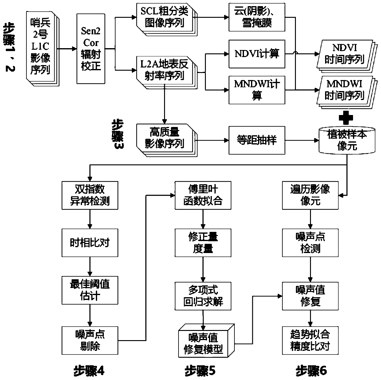
[0032] The present invention will be further described in detail below in conjunction with the accompanying drawings and embodiments.

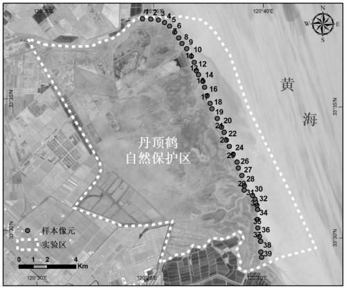
[0033] Taking the Red-crowned Crane Nature Reserve along the central coast of Jiangsu as the experimental area and the normalized difference vegetation index (NDVI) constructed from the Sentinel-2MSI multispectral data as the experimental data, we will further illustrate the impact of coastal tides on remote sensing. The restoration method of the vegetation index time series, the process is as follows figure 1 As shown, the specific steps are as follows:

[0034]Step 1. Acquisition of vegetation index time series. The experimental data comes from Sentinel-2 Multispectral Imager images (Sentinel-2MSI) provided by ESA (https: / / scihub.copernicus.eu / ). By specifying the time and experimental area, the experiment downloaded the geometrically corrected Sentinel-2MSI L1C product that was imaged in 2018 with 68 scenes corresponding to the line code ...


PUM


Abstract

The invention discloses a method for repairing a remote sensing vegetation index time sequence under the influence of coastal zone tides. The method is characterized in that the method comprises the steps: vegetation index time sequence and normalized difference water body index acquisition, tidal influence sample pixel acquisition, time sequence noise point identification, noise point numerical value restoration model construction and vegetation index time sequence restoration evaluation, wherein each sample pixel in an experimental area is traversed, vegetation index noise point correction amount is calculated by utilizing a noise point numerical value restoration model, and the sum of a vegetation index noise point numerical value and a corresponding vegetation index noise point correction amount numerical value are taken as a vegetation index correction value of a vegetation index noise point so as to obtain a restored vegetation index time sequence. The method has the advantages of being wide in application range, high in automation degree, high in robustness and suitable for different spatial resolutions.

Description

technical field [0001] The invention relates to a method for repairing the time series of vegetation index of remote sensing images, in particular to a method for repairing the time series of remote sensing vegetation index under the influence of coastal tides. Background technique [0002] In coastal areas where land and sea interact closely, vegetation (salt marshes, mangroves, seagrass, etc.) acts as an important carbon sink, and continuously promotes the "blue carbon" process of soil through spontaneous primary production and continuous tidal flat deposition. Remote sensing (Remote Sensing) provides large-scale and long-term vegetation dynamic observation techniques, which is helpful to monitor the primary productivity of coastal vegetation and dynamically and quantitatively evaluate changes in the carbon sequestration capacity of coastal ecosystems, which is of great significance. However, remote sensing of vegetation in the coastal zone is particularly complicated due ...

Claims


Application Information

Patent Timeline
Patent Type & Authority Applications(China)
IPC IPC(8): G06T5/00G06T5/10
CPCG06T5/005G06T5/002G06T5/10G06T2207/10032G06T2207/20056G06T2207/30188
Inventor 孙超李加林赵赛帅刘永学金松刘瑞清曹罗丹刘永超冯添
Owner NINGBO UNIV
Why Eureka
Try Eureka