
Navigation method and device for main and auxiliary roads and related equipment

A navigation method and technology of main and auxiliary roads, applied in the field of navigation, can solve the problems of inconvenient navigation guidance, failure to indicate whether the road intersection is a level crossing, and inability to determine auxiliary roads, etc., so as to achieve the effect of avoiding guidance and navigation

Active Publication Date: 2020-05-22
SHENYANG MXNAVI CO LTD
View PDF11 Cites 1 Cited by
  • Summary
  • Abstract
  • Description
  • Claims
  • Application Information

AI Technical Summary

Problems solved by technology

However, the current map data only has the data of the main road and the auxiliary road, does not show the relationship between the main road and the auxiliary road, and cannot determine which main road the auxiliary road belongs to; it does not indicate whether the road intersection is a level crossing, and it is impossible to know the main road. Whether the auxiliary road needs to be guided will bring great inconvenience to the follow-up navigation and lead to misleading

Method used


Image

  • Navigation method and device for main and auxiliary roads and related equipment
  • Navigation method and device for main and auxiliary roads and related equipment
  • Navigation method and device for main and auxiliary roads and related equipment

Examples


Embodiment 1

[0068] According to an embodiment of the present invention, an embodiment of a navigation method for a main and auxiliary road is provided. It should be noted that the steps shown in the flow chart of the accompanying drawings can be executed in a computer system such as a set of computer-executable instructions, and , although a logical order is shown in the flowcharts, in some cases the steps shown or described may be performed in an order different from that shown or described herein.

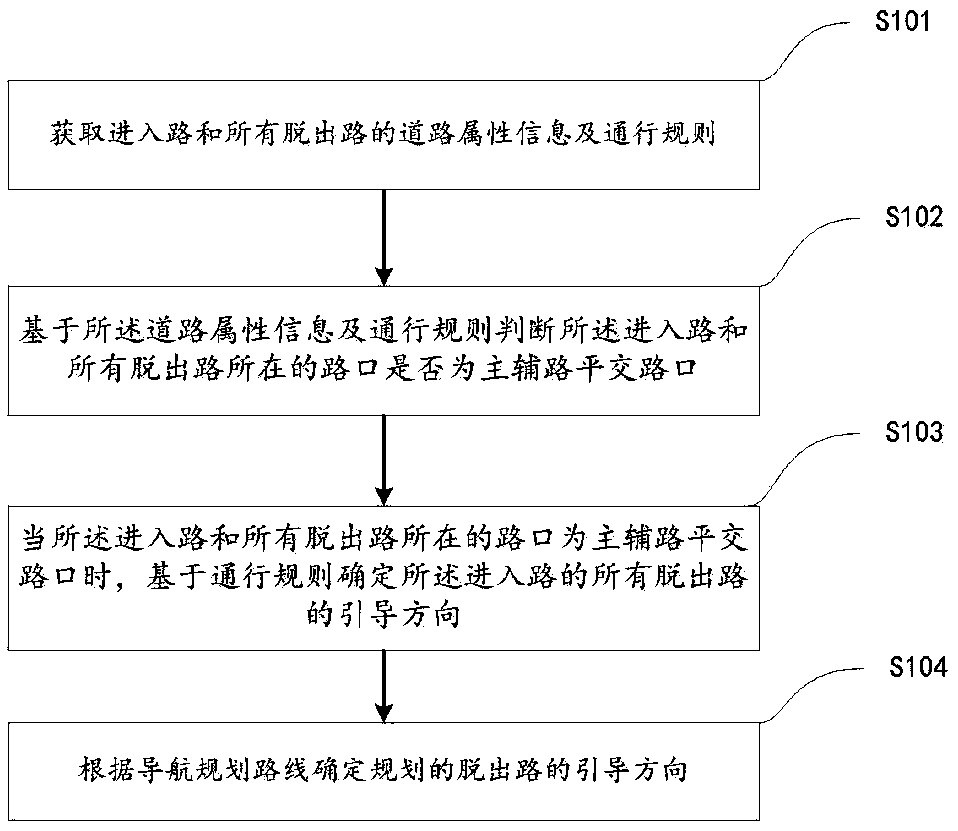
[0069] In some optional embodiments, a navigation method for main and auxiliary roads is provided, such as figure 1 As shown, the following S101-S104 may be included.

[0070] S101: Obtain road attribute information and traffic rules of the entry road and all exit roads;

[0071] In some optional embodiments, the currently implemented traffic rules include: left traffic rules and right traffic rules, for the matching of main and auxiliary roads of roads and the determination and guidance of...

example 1

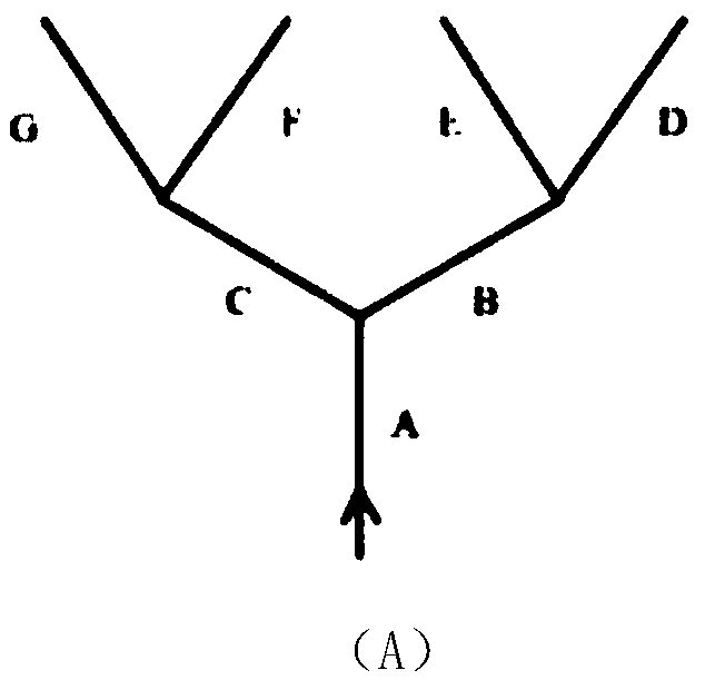
[0106] Example 1: If image 3 In (A), A is the entry road. When there are two first-class roads directly connected to the entry road A in the direction of travel, they are numbered as B and C in the counterclockwise direction, and they are in the direction of travel with the first-class road B. The directly connected second-class roads are numbered D and E counterclockwise, and the second-class roads directly connected to the first-class road C in the direction of travel are numbered F and G counterclockwise.

example 2

[0107] Example 2: If image 3 In (B), A is the entry road. When there are three first-class roads directly connected to the entry road A in the direction of travel, they are numbered counterclockwise as B, C and D, and they are in the direction of travel with the first-class road B. The second-level roads directly connected to the upper road are numbered as E, F and G in the counterclockwise direction, and the second-level roads directly connected to the first-level road D in the direction of travel are numbered as H and I in the counter-clockwise direction. Class road C has no directly connected roads in the direction of travel.


PUM


Abstract

The invention provides a navigation method and device for main and auxiliary roads and related equipment. The method comprises the following steps: acquiring road attribute information and traffic rules of an entrance road and all exit roads; judging whether the intersections where the entrance road and all the exit roads are located are main and auxiliary road level intersections or not based onthe road attribute information and the traffic rules; if yes, determining the guiding directions of all exit roads of the entrance road based on a passing rule; and determining the guiding direction of the planned exit path according to the navigation planning path. The attribute information of each road in the current intersection and whether the road model is the level crossing or not are identified, and whether the main and auxiliary roads need to be guided or not is judged so that correct guiding of the main and auxiliary roads is realized and wrong guiding navigation is avoided.

Description

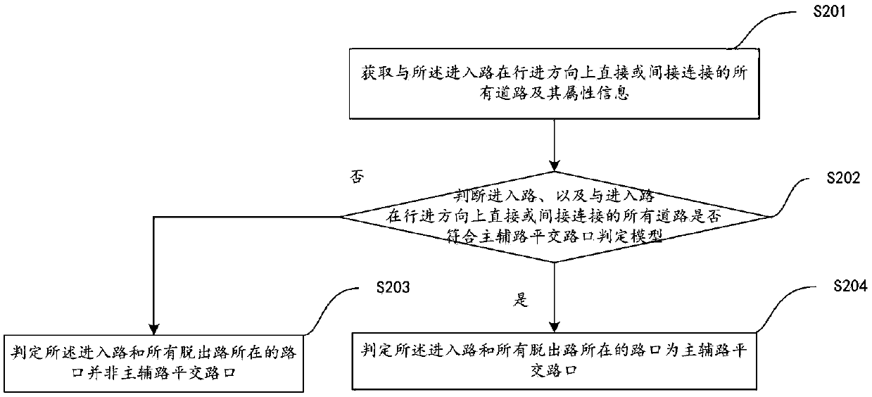
technical field [0001] The invention relates to the technical field of navigation, in particular to a navigation method, device and related equipment for main and auxiliary roads. Background technique [0002] In map data, main roads and auxiliary roads are very important geographical information. However, the current map data only has the data of the main road and the auxiliary road, and does not show the relationship between the main road and the auxiliary road. It is impossible to determine which main road the auxiliary road belongs to; Whether the auxiliary road needs to be guided will bring great inconvenience to the follow-up navigation guidance and easily cause misleading. [0003] In the map data, auxiliary roads are small roads that are parallel and similar to the main road. Common auxiliary roads include: auxiliary roads that share the traffic flow of the main road, and those that do not share the traffic flow of the main road. They exist only as a naming; there i...

Claims


Application Information

Patent Timeline
Patent Type & Authority Applications(China)
IPC IPC(8): G01C21/34
CPCG01C21/343
Inventor 朱夜明董治方
Owner SHENYANG MXNAVI CO LTD
Learn More