Satellite-based ionospheric inversion method based on electromagnetic satellite
An ionosphere and inversion technology, applied in radio wave measurement system, satellite radio beacon positioning system, meteorology, etc., can solve the problem of not being able to achieve all-weather, global coverage of ionosphere detection, and achieve high-precision results
- Summary
- Abstract
- Description
- Claims
- Application Information
AI Technical Summary
Problems solved by technology
Method used
Image
Examples
Embodiment 1
[0045] refer to figure 1 , is a flowchart of a satellite-based ionospheric inversion method based on electromagnetic stars in the present invention. In the present invention, the satellite-based ionospheric inversion method based on the electromagnetic star includes:
[0046] S1, Obtain observation data.
[0047] In the present invention, the way of obtaining the observation data is as follows: the positioning observation data and ionospheric observation data stored in real time in the load, and the positioning observation data and ionospheric observation data stored in Flash are respectively extracted and spliced, and the obtained first observation data and second observation data.
[0048]The specific implementation method is: splicing the real-time positioning observation data stored in the payload and the positioning observation data stored in the Flash in chronological order, and splicing the real-time stored ionospheric observation data in the payload and the ionospher...
Embodiment approach
[0070] The electromagnetic monitoring satellite, that is, the Zhangheng-1 electromagnetic satellite, orbits a sun-synchronous orbit with an orbital height of 508 kilometers, and operates about 30 half-orbits every day. The satellite global replay time of the same area is 5 days. The following describes the embodiment of the present invention by processing a half-track data on April 25, 2018, as follows:
[0071] (1) GPS and BD occultation observation data extraction and separation
[0072] The occultation payload uses real-time + Flash storage for occultation data storage. Real-time storage is used within 65° north and south latitude, and Flash storage is used outside 65° north and south latitude. Extract the ionospheric occultation observation data stored in real-time and Flash storage in the payload, splice the extracted real-time occultation observation data and Flash occultation observation data in chronological order, and then extract and separate individual GPS and BD o...
Embodiment 3
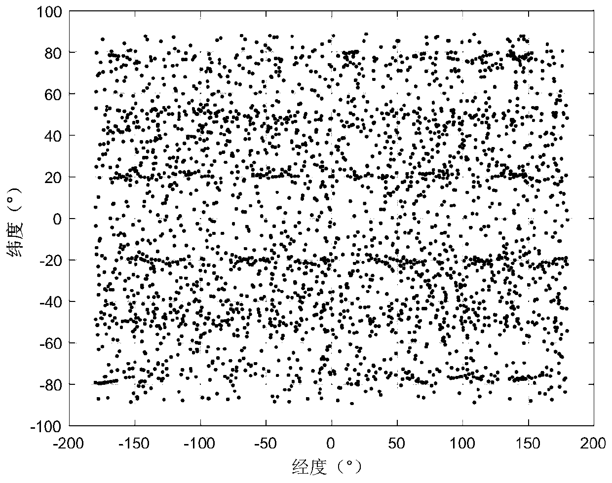
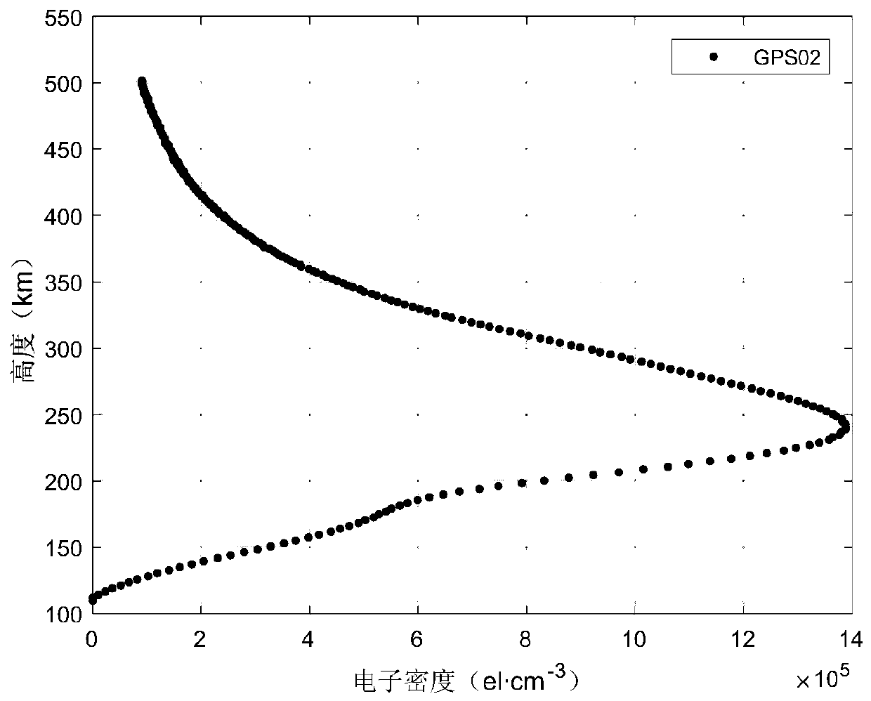
[0090]In order to verify the working performance of the present invention, use QT5.0.2 software to test on Windows10 system i7CPU computer. The test was carried out for about 8 months, and more than 100,000 ionospheric electron density profiles were generated. Among them, the ionospheric occultations were successfully retrieved within one electromagnetic star return period from April 24, 2018 to April 28, 2018. Events plot a floor plan of the global distribution, such as figure 2 shown. Depend on figure 2 It can be seen that the coverage of ionospheric occultation events in one return cycle can reach: longitude -180°~180°, latitude -90°~90°, which can achieve global coverage. The ionospheric electron density profiles of GPS occultation and BD occultation are displayed, respectively as image 3 and Figure 4 It can be seen from the figure that the electron density altitude ranges from 0km to 500km, and the electron density reaches its peak at about 250km, which satisfies ...
PUM
 Abstract
Description
Claims
Application Information
 - Generate Ideas
- Intellectual Property
- Life Sciences
- Materials
- Tech Scout
- Unparalleled Data Quality
- Higher Quality Content
- 60% Fewer Hallucinations
Browse by: Latest US Patents, China's latest patents, Technical Efficacy Thesaurus, Application Domain, Technology Topic, Popular Technical Reports.
© 2025 PatSnap. All rights reserved.Legal|Privacy policy|Modern Slavery Act Transparency Statement|Sitemap|About US| Contact US: help@patsnap.com


