Municipal road land acquisition house statistical method

A statistical method, the technology of municipal roads, applied in the field of land acquisition and house statistics of municipal roads, can solve the problems of easy missing marks, low efficiency, and costing designers, etc., and achieve the effect of fast statistics

Pending Publication Date: 2020-03-17
成都市市政工程设计研究院有限公司
View PDF14 Cites 7 Cited by
  • Summary
  • Abstract
  • Description
  • Claims
  • Application Information

AI Technical Summary

Problems solved by technology

The existing statistical method for land-expropriated houses is to manually delineate and measure the area of ​​the houses one by one in CAD software. The disadvantage of this method is that when the distribution of houses along the line is relatively scattered or the number of houses is large, it takes a lot of time for designers to make statistics, and it is easy to Missing marks, when the route plan changes, it has to be counted again, which is very inefficient

Method used


Image

  • Municipal road land acquisition house statistical method

Examples


Embodiment Construction

[0025] The present invention will be described in further detail below in conjunction with the accompanying drawings.

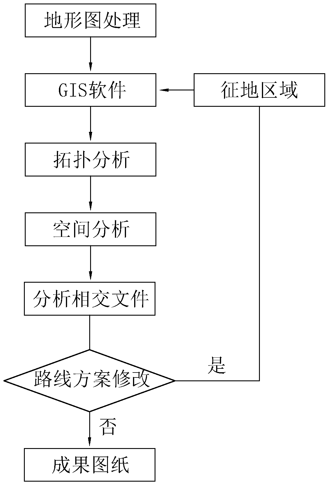
[0026] A statistical method for municipal road land acquisition and houses, such as figure 1 As shown, it includes the following steps: S1. Select and determine the land acquisition and demolition area according to the measured topographic map provided by the Bureau of Surveying and Mapping; S2. Clean up the topographic map, remove unrelated layers, and keep the house layer and its annotations; S3. Convert the format of the cleaned topographic map and import it into the GIS software; S4. In the GIS software, detect the outline of the house, eliminate isolated line segments, and then perform topology analysis to form a district file; according to the previously imported house Note, perform attribute assignment on the district file, and establish the attribute structure of whether the house is expropriated in the district file; S5, import the land acquisition ...


PUM


Abstract

The invention relates to a municipal road land acquisition house statistical method which comprises the following steps: S1, selecting and determining a land acquisition demolition area according to an actually measured topographic map provided by a survey bureau; S2, cleaning the topographic map, removing unassociated layers, and reserving house layers and annotations thereof; S3, performing format conversion on the cleaned topographic map, and importing the topographic map into GIS software; s4, in GIS software, detecting the house contour line, removing isolated line segments, and then performing topology analysis to form a zone file; according to the previously imported house annotation, performing attribute assignment on the area file, and establishing an attribute structure for judging whether the house is expropriated or not in the area file; and S5, importing the land expropriation and demolition area and the area file into a spatial analysis module together, performing intersection analysis to form an intersection file, and superposing the original house area file according to the attributes of the intersection file to obtain a result drawing of the house in the land expropriation and demolition area. And land acquisition and house demolition statistics becomes faster.

Description

technical field [0001] The invention relates to the technical field of geographic information processing, in particular to a statistical method for municipal road land requisitioned houses. Background technique [0002] With the optimization and development of the city, municipal roads continue to extend to surrounding suburban counties, and the construction of municipal roads will face the problem of land acquisition and house demolition investment along the line. It is an essential content in the investment estimation in the feasibility study stage of the road engineering design to make statistics on the types and areas of land-expropriated houses along the line. According to the latest topographic map, the existing statistical methods mark the types and areas of houses within the scope of the ground line one by one, and then classify and count. [0003] Surveying and Mapping of Existing Topography in Engineering Design Figure 1 Generally, geometric and coordinate featur...

Claims


Application Information

Patent Timeline
Patent Type & Authority Applications(China)
IPC IPC(8): G06Q90/00G06Q50/26G06N3/08G06N3/04G06F16/29
CPCG06Q50/26G06Q90/205G06F16/29G06N3/084G06N3/044
Inventor 余波
Owner 成都市市政工程设计研究院有限公司
Why Eureka
Try Eureka