Floodplain average elevation determination method based on sediment carrying force change

A technology of average elevation and determination method, applied in climate change adaptation, design optimization/simulation, instruments, etc., can solve problems such as large difference in average elevation of the beach, difficulty in determining the location of the beach, and unclear boundary between the beach and the main trough, etc. Achieve high precision, meet engineering needs, and strong operability

Active Publication Date: 2020-02-25
HOHAI UNIV
View PDF4 Cites 0 Cited by
  • Summary
  • Abstract
  • Description
  • Claims
  • Application Information

AI Technical Summary

Problems solved by technology

This method is quite artificial, and in many cases the boundary line between the beach and the main channel is not obvious, it is difficult to determine the position of the beach, and the average elevation of the beach obtained by different workers is quite different. Therefore, it is necessary to use a A quantitative method to determine the elevation of the beach, and then determine the range of the beach according to the elevation of the beach

Method used


Image

  • Floodplain average elevation determination method based on sediment carrying force change
  • Floodplain average elevation determination method based on sediment carrying force change
  • Floodplain average elevation determination method based on sediment carrying force change

Examples


Embodiment Construction

[0040] The embodiments of the present invention are described in detail below, and examples of the embodiments are shown in the accompanying drawings. The following embodiments described with reference to the accompanying drawings are exemplary, and are only used to explain the present invention, and cannot be construed as limiting the present invention.

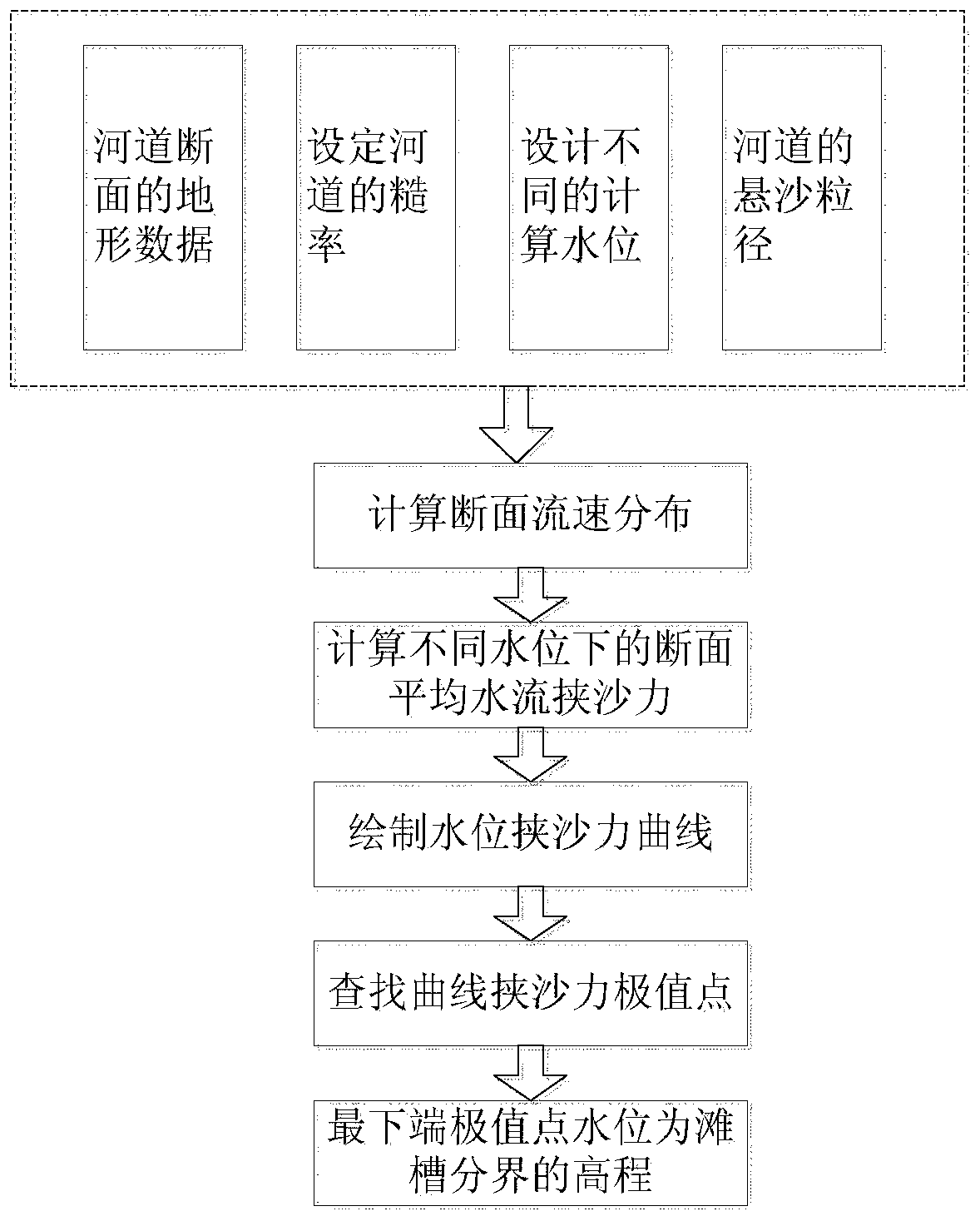
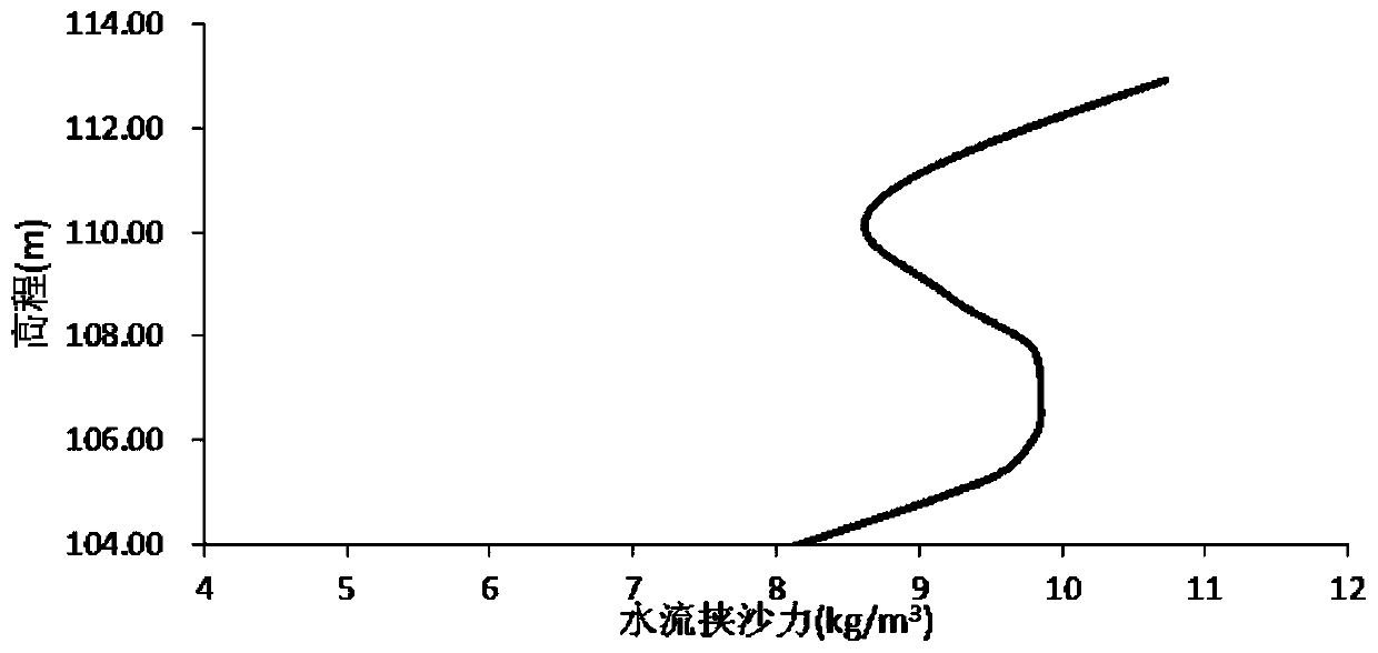
[0041] At the moment of floodplain, the sediment-carrying capacity of the compound channel gradually decreases and then gradually increases with the depth of the water. According to this variation characteristic, the elevation of the floodplain can be determined. Such as figure 1 As shown, the process of the method for judging the floodplain and main trough of the compound section of the present invention is as follows:

[0042] Step 1. Obtain the topographic data of the river channel section, arrange N elevation points from the left side to the right side of the river channel, and the corresponding elevation points are respecti...


PUM


Abstract

The invention discloses a floodplain average elevation determination method based on sediment carrying force change, which adopts a formula to calculate and obtain flow velocity distribution of a transverse section of a compound section under different water level conditions, and calculates and obtains a water level sediment carrying capacity relation curve according to a suspended load water flowsediment carrying capacity formula. In order to judge the change rate of the sediment carrying force along with the water level, the relation between the slope of the sediment carrying force curve and the water level is further established, the minimum extreme point of the slope on the relation curve is captured, and the elevation corresponding to the extreme point is the representative elevationof the flood bank. According to the method, the floodplain elevation can be determined without manually judging the beach-trough boundary point, and the defect that the beach-trough boundary point needs to be manually judged in advance in a traditional method is overcome.

Description

Technical field [0001] The invention relates to a method for determining the average elevation of a river floodplain based on changes in the sediment-carrying capacity, and belongs to the technical field of floodplain division in river bed evolution analysis and river simulation. Background technique [0002] A large number of compound open channels exist in natural rivers. The lower Yellow River, Huaihe River and the main stream of Songhua River in my country are all typical compound open channels. The floodplain problem of the lower Yellow River is related to the safety of people's lives and property, and has always been highly valued by the state. Among them, the determination of the floodplain elevation is an important part of the Yellow River floodplain management. The elevation can provide a scientific basis for the optimal design of the flood passage section of the river and the cross section shape after use, which not only meets the flood control requirements, but also ma...

Claims


Application Information

Patent Timeline
IPC IPC(8): G06F30/20G06F111/10G06F119/14
CPCY02A10/40
Inventor 吴腾刘旖萱秦杰冯兴国吴玲莉王瑞彩夏莉敏
Owner HOHAI UNIV
Why Eureka
Try Eureka