Co-location method for marine targets based on satellite-borne AISs and infrared camera

An infrared camera and co-location technology, applied in satellite radio beacon positioning systems, measuring devices, instruments, etc., can solve the problems of difficulty in obtaining the precise position of the target, poor target correlation effect, etc. The effect of improving positioning accuracy

Active Publication Date: 2020-02-11
NAT INNOVATION INST OF DEFENSE TECH PLA ACAD OF MILITARY SCI
View PDF7 Cites 4 Cited by
  • Summary
  • Abstract
  • Description
  • Claims
  • Application Information

AI Technical Summary

Problems solved by technology

At present, the global nearest neighbor (GNN) algorithm is the most commonly used method for multi-source sensor target association, but the target association effect is not good under the system error, and it is difficult to obtain the precise position of the target.

Method used


Image

  • Co-location method for marine targets based on satellite-borne AISs and infrared camera
  • Co-location method for marine targets based on satellite-borne AISs and infrared camera
  • Co-location method for marine targets based on satellite-borne AISs and infrared camera

Examples


Embodiment Construction

[0042] In order to make the purpose, technical solution and advantages of the present invention clearer, the technical solution of the present invention will be clearly and completely described below in conjunction with specific embodiments of the present invention and corresponding drawings. Apparently, the described embodiments are only some of the embodiments of the present invention, but not all of them. Based on the embodiments of the present invention, all other embodiments obtained by persons of ordinary skill in the art without making creative efforts fall within the protection scope of the present invention.

[0043] The technical solutions provided by the embodiments of the present invention will be described in detail below in conjunction with the accompanying drawings.

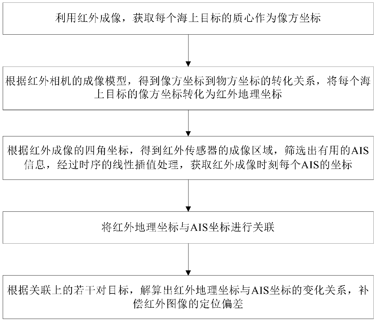
[0044] The embodiment of the present invention provides a method for cooperative positioning of maritime targets based on spaceborne AIS and infrared cameras, as shown in the attached figure 1 As ...


PUM


Abstract

The invention discloses a co-location method for marine targets based on satellite-borne AISs and an infrared camera. The method comprises: S1, using infrared imaging to obtain a centroid of each seatarget as an image space coordinate; S2, according to an imaging model of the infrared camera, acquiring the conversion relationship from the image space coordinates to object space coordinates, and converting the image space coordinate of each marine target into an infrared geographic coordinate; S3, according to four-corner coordinates of the infrared imaging, obtaining an imaging area of an infrared sensor, screening out useful AIS information, and performing sequential linear interpolation processing to obtain a coordinate of each AIS at an infrared imaging moment; S4, associating the infrared geographic coordinates with the AIS coordinates; and S5, according to the plurality of pairs of associated targets, calculating the change relationship between the infrared geographic coordinatesand the AIS coordinates to compensate the positioning deviation of an infrared image. The co-location method for the marine targets based on the satellite-borne AISs and the infrared camera can correct a location error of the infrared image and improve the location accuracy of non-cooperative targets.

Description

technical field [0001] The invention relates to the technical field of maritime target position monitoring, in particular to a method for cooperative positioning of maritime targets based on space-borne AIS and infrared cameras. Background technique [0002] Compared with shore-based and other maritime surveillance platforms, space-based maritime surveillance has a long range, wide coverage, and no national border restrictions and political disputes. It is an important development direction in the field of satellite applications in various countries. Maritime targets have strong infrared radiation characteristics. It is easy to detect maritime targets with infrared cameras. Compared with visible light, infrared imaging sensors can also work at any time, so they are well used in space-based ocean surveillance. Automatic Identification System (AIS) is a ship self-broadcast navigation system based on GPS technology, VHF technology and self-organizing time division multiple acce...

Claims


Application Information

Patent Timeline
Patent Type & Authority Applications(China)
IPC IPC(8): G01S19/48G01S19/40
CPCG01S19/40G01S19/48
Inventor 刘勇曹璐郭鹏宇李献斌王建
Owner NAT INNOVATION INST OF DEFENSE TECH PLA ACAD OF MILITARY SCI
Why Eureka
Try Eureka