Boundary line position information acquisition method and equipment

A technology of location information and collection method, applied in geographic information database, image data processing, structured data retrieval, etc., can solve the logical judgment of the location of the collinear boundary line, the logical error of the collinear boundary line, and the inability to record the low efficiency. and other problems to achieve the effect of eliminating logic errors, reducing logic errors, and improving work efficiency and quality

Active Publication Date: 2019-11-22
ACADEMY OF PLANNING & DESIGNING OF THE MINIST OF AGRI
View PDF6 Cites 1 Cited by
  • Summary
  • Abstract
  • Description
  • Claims
  • Application Information

AI Technical Summary

Problems solved by technology

[0005] 1. The paper-based field investigation form is separated from the electronic internal data processing, resulting in a lot of repetitive work for recording and assigning attribute values, which is inefficient, and because the paper form is manually recorded and manually entered into the electronic system, it is easy error;
[0006] 2. In many cases, a parcel usually has a common boundary line with multiple parcels, that is, a collinear boundary line. The current method records or collects location information separately for each boundary line, and the recording efficiency is low and It is impossible to make a logical judgment on the position of the collinear boundary line, which may easily cause logical errors of the collinear boundary line

Method used


Image

  • Boundary line position information acquisition method and equipment
  • Boundary line position information acquisition method and equipment
  • Boundary line position information acquisition method and equipment

Examples


Embodiment Construction

[0029] The technical solution of the present invention will be described in detail below with reference to the accompanying drawings.

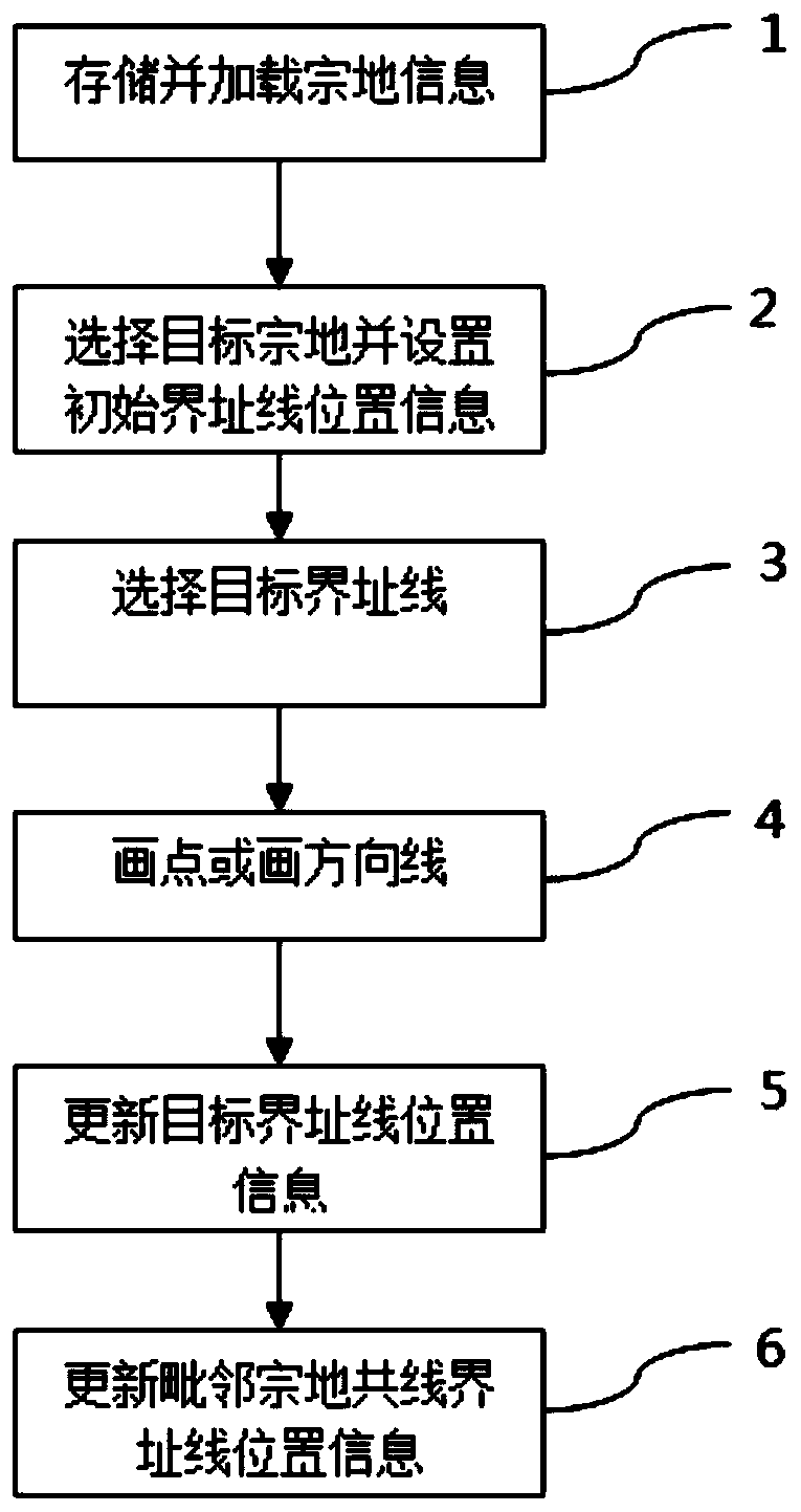
[0030] Such as figure 1 As shown, the method for collecting boundary address line position information of the present invention includes the following steps:

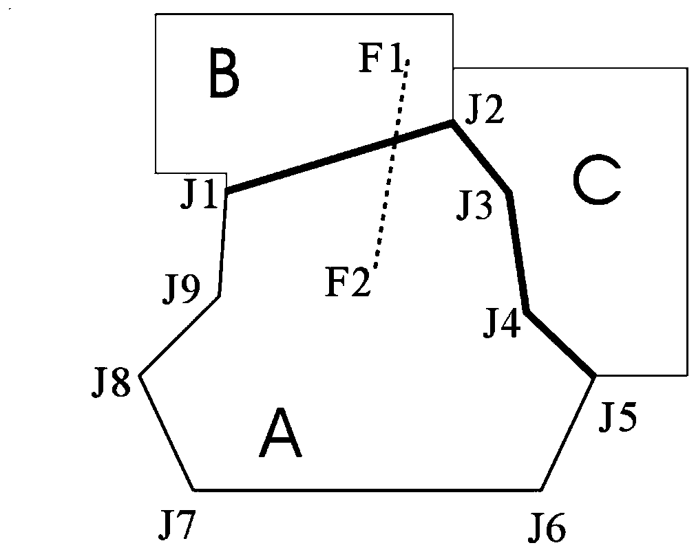
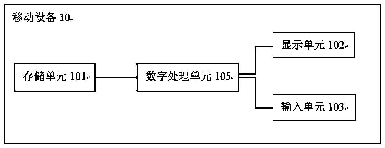
[0031] Step 1: Store and load parcel information in the mobile touch screen device. Parcel information includes parcel polygons, parcel boundary address points, parcel boundary address line vector graphic information, and boundary line attribute table corresponding to the boundary line graphic information. The boundary line attribute table includes the location information for storing the boundary line Field. in figure 2 In, the parcel information includes polygons A, B, and C, the boundary points included in the parcel A are J1, J2, J3,..., J9, J1, and the boundary lines included in the parcel A are J1J2, J2J3, J3J4, ……J9J1;

[0032] Step 2: Select the target parcel to be collected, displ...


PUM


Abstract

The invention discloses a boundary line position information acquisition method based on mobile equipment and the equipment thereof. The method comprises the steps of storing and loading the parcel information in mobile equipment, wherein the parcel information comprises a position field used for storing boundary line position information; selecting a target parcel to be collected; selecting one or more boundary lines as target boundary lines of the to-be-acquired boundary line position information; drawing a point or a direction line in the mobile equipment; updating boundary line position information of the target boundary line according to the drawn point or the drawn direction line; and updating the position information of the adjacent parcel collinear boundary line according to the updated boundary line position information. According to the method, the boundary line position information acquisition and recording mode is improved. The boundary line position information acquisitionand recording efficiency and the accuracy are improved.

Description

Technical field [0001] The invention relates to a method for collecting position information of a boundary line. More specifically, the present invention relates to a method for improving the efficiency and accuracy of recording the location information of a boundary line. Background technique [0002] The boundary line refers to the ownership boundary around the parcel. The position information of the boundary line is the information reflecting the actual position of the boundary line. It is used to determine the specific location of the boundary line in the investigation of the title and the settlement of real estate disputes. Key descriptive information. When the type of boundary line is determined, the location information of the boundary line clarifies the right ownership of the boundary line marker itself, which is an important basis for determining the right ownership of the boundary line marker. [0003] According to the common practice of real estate registration investi...

Claims


Application Information

Patent Timeline
Patent Type & Authority Applications(China)
IPC IPC(8): G06F16/29G06T11/20
CPCG06F16/29G06T11/206
Inventor 赵虎易湘生裴志远王飞
Owner ACADEMY OF PLANNING & DESIGNING OF THE MINIST OF AGRI
Why Eureka
Try Eureka