Urban underground drainage pipe network data supplementing and perfecting method and system
A technology for drainage pipe network and data, which is applied in the field of urban underground drainage pipe network data supplement and improvement method and system, and can solve the problems of no data supplement and perfection, fast and reasonable, etc.
- Summary
- Abstract
- Description
- Claims
- Application Information
AI Technical Summary
Problems solved by technology
Method used
Image


Examples
Embodiment 1
[0066] A method for supplementing and perfecting urban underground drainage pipe network data, such as figure 1 As shown, step 100 is executed to mark the pipe type, manually analyze the pipe diameter thresholds of main pipes and branch pipes according to the existing pipe diameter data, and distinguish the pipelines into main pipes and branch pipes according to the pipe diameter thresholds.
[0067] Step 110 is executed to fill the pipe diameter or section shape data according to the topology. Calculate the included angle of all the pipelines connected to the pipeline, assign the pipe width of the pipeline with the smallest included angle to the pipeline, and include the included angle between the main pipe and the main pipe and / or the branch pipe and the branch pipe. The calculation method of the included angle includes the following steps:
[0068] Step 111, calculate the cosine value cosθ for each pipeline through the position of the upstream and downstream nodes, the cal...
Embodiment 2
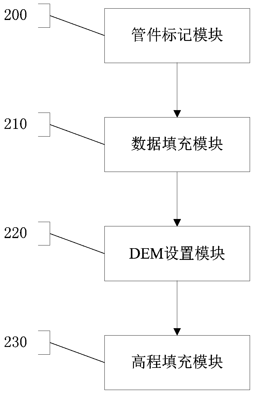
[0073] Such as figure 2 As shown, a system for supplementing and improving urban underground drainage network data includes a pipe marking module 200 , a data filling module 210 , a DEM setting module 220 and an elevation filling module 230 .
[0074] Pipe marking module 200: used for pipe type marking, manually analyzing the pipe diameter thresholds of main pipes and branch pipes according to the existing pipe diameter data, and distinguishing pipelines into main pipes and branch pipes according to the pipe diameter thresholds.
[0075] Data filling module 210: used to fill pipe diameter or section shape data according to the topology, calculate the included angles of all pipelines connected to the pipeline, and assign the pipe width of the pipeline with the smallest included angle to the pipeline. Wherein, the included angle includes the included angle between the main pipe and the main pipe and / or the branch pipe and the branch pipe. The calculation method of the included...
Embodiment 3
[0079] The present invention provides a scheme for automatically supplementing and perfecting urban pipe network data attributes by combining the pipe network topology structure with the actual situation of the actual pipe network project. data support.
[0080] Digitize the urban pipeline network data. The digitalized pipeline attributes include upstream bottom elevation, downstream bottom elevation, pipe diameter, pipeline type (main pipe or branch pipe), buried depth and other parameters. The digital model is as follows: image 3 shown.
[0081] In the process of digitizing the underground drainage pipe network, there are data missing and business applications cannot be carried out. The methods for automatically supplementing and perfecting urban pipe network data include pipeline type marking, pipe diameter or section shape data filling, pipeline reference DEM setting, and topology based Relational filling elevation, filling elevation according to buried depth and other p...
PUM
 Abstract
Description
Claims
Application Information
 - Generate Ideas
- Intellectual Property
- Life Sciences
- Materials
- Tech Scout
- Unparalleled Data Quality
- Higher Quality Content
- 60% Fewer Hallucinations
Browse by: Latest US Patents, China's latest patents, Technical Efficacy Thesaurus, Application Domain, Technology Topic, Popular Technical Reports.
© 2025 PatSnap. All rights reserved.Legal|Privacy policy|Modern Slavery Act Transparency Statement|Sitemap|About US| Contact US: help@patsnap.com