A global environment map generation method for driverless road level

A global environment and unmanned driving technology, which is applied in the direction of instruments, calculations, character and pattern recognition, etc., can solve the problems of inaccurate weather conditions and low production costs, and achieve the effect of high accuracy and precision and good positioning accuracy

Active Publication Date: 2022-05-20
UNIV OF ELECTRONICS SCI & TECH OF CHINA
View PDF7 Cites 0 Cited by
  • Summary
  • Abstract
  • Description
  • Claims
  • Application Information

AI Technical Summary

Problems solved by technology

Many traditional driverless cars use GPS for map drawing. However, as mentioned above, this existing technical solution has great problems and shortcomings, that is, it is vulnerable to terrain, weather conditions and lack of accuracy. exact question
Moreover, the production cost is not low. It is obviously very disadvantageous to use the map produced by this method to promote driverless cars.

Method used


Image

  • A global environment map generation method for driverless road level
  • A global environment map generation method for driverless road level
  • A global environment map generation method for driverless road level

Examples


Embodiment Construction

[0043] The technical solutions of the present invention will be clearly and completely described below in conjunction with the embodiments. Apparently, the described embodiments are only some of the embodiments of the present invention, not all of them. Based on the embodiments of the present invention, all other embodiments obtained by those skilled in the art without making creative efforts belong to the protection scope of the present invention.

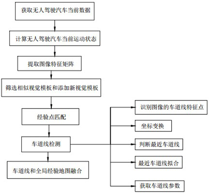
[0044] refer to Figure 1-2 , the present invention provides a technical solution:

[0045] A road-level global environment map generation method for unmanned driving, such as Figure 1-2 shown, including the following steps:

[0046] S1. Obtain the current data of the unmanned vehicle, continue to locate and capture images during the movement of the unmanned vehicle, record the sequence number of the current frame image as h, and locate the coordinates (x h ,y h ) Draw the trajectory of the unmanned vehicle to obtain the glob...


PUM


Abstract

The invention discloses a method for generating a road-level global environment map for unmanned driving, which can obtain current data of unmanned vehicles, calculate the current motion state of unmanned vehicles, extract image feature matrices, screen similar visual templates and add new visual Steps such as template, experience point matching, lane line detection, and lane line and global experience map fusion finally generate an unmanned road-level global environment map. Unmanned vehicles use on-board sensors to perceive the surrounding environment of the vehicle, and according to the perceived road , vehicle position and obstacle information to achieve the purpose of unmanned driving, and overcome the traditional problems of being susceptible to terrain, weather conditions and inaccurate precision. A road-level global environment map generation for unmanned driving in the present invention Method, by continuously capturing environmental information during vehicle driving to generate a global experience map, combined with multi-lane line detection, a road-level global environment map with high accuracy is obtained.

Description

technical field [0001] The invention relates to the technical field of unmanned driving, in particular to a method for generating a road-level global environment map for unmanned driving. Background technique [0002] With the vigorous development of communication technology, machine intelligence technology, computer network technology and geographic information system technology, unmanned driving has gained wide attention in many aspects such as military, civilian and scientific research. Interdisciplinary research in many fields, such as electronics, artificial intelligence, etc., has a very broad application prospect. Driverless car is a kind of smart car, which can also be called a wheeled mobile robot. Since the 1970s, developed countries such as the United States, Britain, and Germany have begun to conduct research on driverless cars. Over the years, in the feasibility Significant breakthroughs have been made in terms of practicality and practicality. [0003] At pre...

Claims


Application Information

Patent Timeline
Patent Type & Authority Patents(China)
IPC IPC(8): G06V20/56
CPCG06V20/588
Inventor 程洪邓桂林杜鹏赵洋
Owner UNIV OF ELECTRONICS SCI & TECH OF CHINA
Why Eureka
Try Eureka