Lane line data fusion method based on high-precision map

A data fusion and lane line technology, applied in directions such as road network navigators, can solve problems such as difficulty in ensuring accuracy and reliability

Active Publication Date: 2020-12-18
禾多科技(广州)有限公司
View PDF6 Cites 0 Cited by
  • Summary
  • Abstract
  • Description
  • Claims
  • Application Information

AI Technical Summary

Problems solved by technology

However, the accuracy and reliability of the traditional lane line data processing based on a single data source cannot be guaranteed without additional data for cross-validation

Method used


Image

  • Lane line data fusion method based on high-precision map

Examples


Embodiment Construction

[0062] The present invention will be described in detail below in conjunction with the accompanying drawings, so that those of ordinary skill in the art can implement it after referring to this specification.

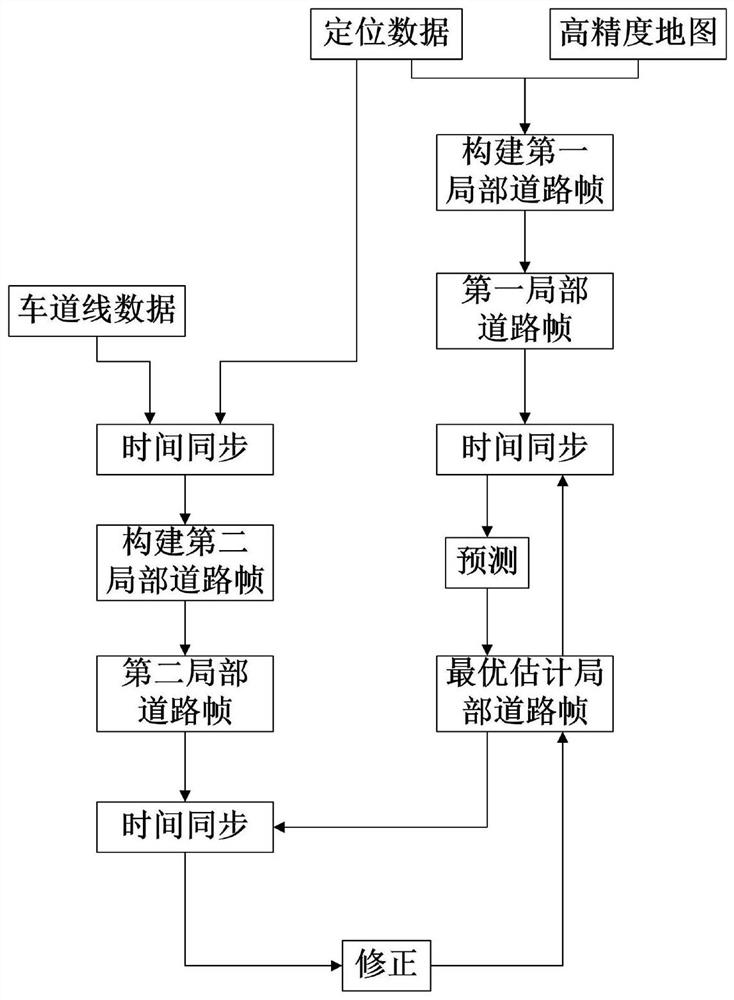
[0063] Such as figure 1 As shown, a high-precision map-based lane line data fusion method mainly includes the following steps:

[0064] S1. Combining the positioning data of the vehicle with the high-precision map and the lane line data sensed at the position corresponding to the positioning data to construct a first local road frame and a second local road frame;

[0065] S2. Obtain an optimally estimated local road frame according to the positioning data and the high-precision map; wherein, the optimally estimated local road frame refers to an optimal estimated value of the current local road frame;

[0066] S3. Timely synchronize the optimal estimated local road frame with the positioning data;

[0067] S4. Based on the first local road frame obtained in S1, update...


PUM


Abstract

The invention discloses a lane line data fusion method based on a high-precision map. The method comprises the following steps: respectively combining positioning data of a vehicle with the high-precision map and lane line data sensed at a position corresponding to the positioning data to construct first and second local road frames; obtaining an optimal estimation local road frame according to the positioning data and the high-precision map; synchronizing the optimal estimation local road frame with the positioning data in time; according to the first local road frame, updating the optimal estimation local road frame which is subjected to time synchronization with the positioning data; synchronizing the updated optimal estimation local road frame with the lane line data in time; and according to the second local road frame, correcting the optimal estimation local road frame which is subjected to time synchronization with the lane line data. According to the method provided by the invention, a lane line recognized through sensing, the high-precision map and the positioning data are fused, consequently, more accurate and stable lane line output is obtained, and meanwhile, a technical effect of monitoring reliability of the lane line data itself is realized.

Description

technical field [0001] The invention relates to the technical field of unmanned driving, in particular to a lane line data fusion method based on a high-precision map. Background technique [0002] As a data source highly dependent on the perception, path planning and control of unmanned vehicles, the accuracy and stability of lane line data is crucial to the safety and stability of vehicle driving. However, the accuracy and reliability of the traditional lane line data processing based on a single data source cannot be guaranteed because there is no additional data for cross-validation. How to fuse the perceived and recognized lane lines with prior high-precision map data and monitor the reliability of the lane line data, so as to obtain more accurate and stable lane line output results is of great significance for the safe and stable driving of unmanned vehicles. Contents of the invention [0003] It is an object of the present invention to solve at least the above-ment...

Claims


Application Information

Patent Timeline
Patent Type & Authority Patents(China)
IPC IPC(8): G01C21/30
CPCG01C21/30
Inventor 胡禹超戴震
Owner 禾多科技(广州)有限公司
Why Eureka
Try Eureka