A high-precision mapping method based on inertial system

An inertial system, high-precision technology, applied in surveying and navigation, navigation through speed/acceleration measurement, distance measurement, etc., can solve the problem that GPS or Beidou cannot perform surveying and mapping accuracy

Active Publication Date: 2022-07-26
TIANJIN NAVIGATION INSTR RES INST
View PDF10 Cites 0 Cited by
  • Summary
  • Abstract
  • Description
  • Claims
  • Application Information

AI Technical Summary

Problems solved by technology

[0003] The purpose of the present invention is to overcome the deficiencies of the prior art, provide a high-precision surveying and mapping method based on an inertial system, and solve the problems that existing GPS or Beidou cannot perform surveying and mapping and low precision when the signal is invisible

Method used


Image

  • A high-precision mapping method based on inertial system
  • A high-precision mapping method based on inertial system
  • A high-precision mapping method based on inertial system

Examples


Embodiment Construction

[0157] The present invention will be further described in detail below through specific examples. The following examples are only descriptive, not restrictive, and cannot limit the protection scope of the present invention.

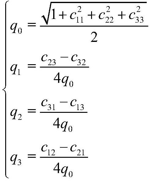
[0158] Taking the implementation of the oil pipeline surveying and mapping process as an example, the surveying and mapping system mainly includes an inertial navigation system composed of three fiber optic gyroscopes and three accelerometers, and an odometer speed measuring device. The odometer is used in the pipeline to measure the mileage increment of the system moving in the pipeline. At the same time, a reference point is selected at an interval of 1km to 2km outside the pipeline, and the precise position information of the point is measured by high-precision GPS as the calibration position point. When it passes through the reference position, it will record the data synchronously with the inertial navigation system, and store the output data of the g...


PUM


Abstract

The invention relates to a high-precision surveying and mapping method based on an inertial system. A strapdown inertial navigation system is composed of a three-axis gyroscope and a three-axis accelerometer to perform inertial navigation calculation; the position increment output by the odometer is used for dead reckoning, Output attitude, heading, speed and position information; establish a mathematical model of inertial navigation strapdown solution and odometer dead reckoning error, use Kalman filtering method to estimate and measure odometry and inertial navigation errors; use pre-measurement outside the pipeline to specify The position information of the equidistant magnetic punctuation points is used for data correction, and the RTS filtering technology is used for backtracking filtering, so that each sampling point is the optimal smoothing point of the Kalman filter. The present invention utilizes the inertial device and odometer data collected by post-processing, combined with the external precise magnetic punctuation signal, and provides the position information of a specific measurement point and the position trajectory of the path of the entire pipeline under test by combining the navigation algorithm, so as to meet the requirements of the oil pipeline. , tunnels, railways and other fields of high-precision surveying and mapping requirements.

Description

technical field [0001] The invention belongs to the technical field of post-processing of surveying and mapping technology, and relates to a precise surveying and mapping technology for using inertial elements to carry out positions of petroleum inertial navigation, tunnels and other environments, in particular to a high-precision surveying and mapping method based on an inertial system. Background technique [0002] In the use environment of oil pipelines, tunnels, railways, etc., for safety reasons, for example, oil pipelines need to be regularly inspected for pipeline integrity, and possible safety hazards need to be located, or the deformation of road tunnels and rails needs to be measured along the entire path. At the same time, Beidou or GPS cannot meet centimeter-level positioning accuracy due to the problems of accuracy and visibility. SUMMARY OF THE INVENTION [0003] The purpose of the present invention is to overcome the deficiencies of the prior art, provide a ...

Claims


Application Information

Patent Timeline
Patent Type & Authority Patents(China)
IPC IPC(8): G01C21/18G01C21/16G01C22/00
CPCG01C21/18G01C21/165G01C21/005G01C22/00
Inventor 侯斌屈建龙赵云旭王得山
Owner TIANJIN NAVIGATION INSTR RES INST
Why Eureka
Try Eureka