A land price measuring and calculating method and system

A land price and land parcel technology, applied in computing, instruments, data processing applications, etc., can solve problems such as complexity and inaccurate evaluation results, and achieve the effect of reducing components, accurate measurement results, and reasonable measurement

Pending Publication Date: 2019-06-18
SHENZHEN URBAN PLANNING & LAND RES CENT
View PDF0 Cites 0 Cited by
  • Summary
  • Abstract
  • Description
  • Claims
  • Application Information

AI Technical Summary

Problems solved by technology

There are many and complex factors to be considered in the calculation process of these methods, and there are still many subjective judgments, which may easily cause the evaluation results to be inaccurate

Method used


Image

  • A land price measuring and calculating method and system
  • A land price measuring and calculating method and system
  • A land price measuring and calculating method and system

Examples


Embodiment 1

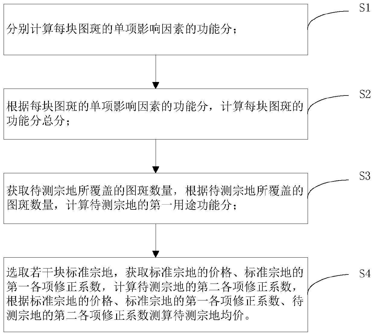
[0070] figure 1 It is a flow chart of a land price measurement and calculation method of the present invention, with reference to figure 1 , a land price measurement method, including steps S1 to S4.

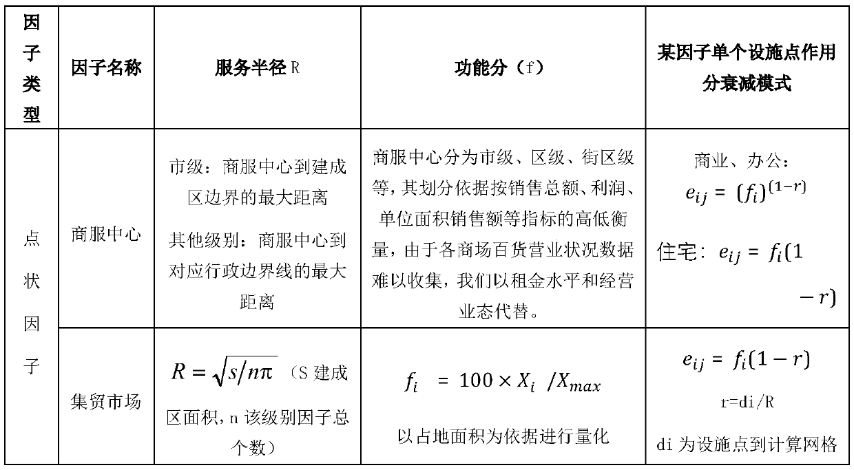
[0071] S1, calculate the function score of the single influencing factor of each patch respectively;

[0072] S2, according to the functional score of the individual influencing factors of each patch, calculate the total score of the functional score of each patch;

[0073] S3, obtain the number of map spots covered by the parcel to be tested, and calculate the function score of the parcel to be tested according to the number of map spots covered by the parcel to be tested;

[0074] S4. Select several standard parcels, obtain the price of the standard parcels and the first correction coefficients of the standard parcels, and calculate the second correction coefficients of the parcels to be tested. According to the price of the standard parcels, the standard parcels The first ...

Embodiment 2

[0132] figure 2 It is a block diagram of a land price measurement and calculation system module of the present invention, referring to figure 2 , a land price measurement system, comprising:

[0133] The first calculation module is used to calculate the function score of the single influencing factor of each plot respectively;

[0134] The second calculation module is used to calculate the total score of the functional points of each patch according to the functional points of the individual influencing factors of each patch;

[0135] Obtaining a calculation module, used to obtain the number of spots covered by the parcel to be tested, and calculate the functional score of the parcel to be tested according to the number of spots covered by the parcel to be tested;

[0136] Select the calculation module, which is used to select a number of standard parcels, obtain the price of the standard parcel, the first correction coefficient of the standard parcel, and calculate the se...


PUM


Abstract

The invention discloses a land price measuring and calculating method and system. The method comprises the following steps of: calculating a function score of a single influence factor of each patternspot; according to the function score of the single influence factor of each pattern spot, calculating a total score of the function score of each pattern spot; obtaining the number of pattern spotscovered by the to-be-detected land parcel, according to the number of pattern spots covered by the to-be-detected land parcel, calculating the functional function score of the to-be-detected land parcel, referring to the standard parcel price, the standard parcel correction factor, and the functional function score of the standard parcels, measuring the average price of the to-be-detected land parcel. Compared with an existing land price assessment method, subjective judgment components are reduced, the land price assessment result is more accurate, various influence factors are considered, and land price assessment is more reasonable. The invention relates to the technical field of land price calculation.

Description

technical field [0001] The invention relates to the technical field of land price measurement and calculation, in particular to a method and system for land price measurement and calculation. Background technique [0002] Map Ban is a basic survey unit divided according to a single land type, as well as administrative boundaries, land ownership boundaries or linear features. [0003] Parcels of land refer to land parcels within the boundaries of the ownership of the land-use right holder; they are the basic unit of land registration and cadastral survey. [0004] Homogeneous area: a land area with basically the same land use and utilization conditions. Homogeneous area refers to the area with similar or relatively consistent natural elements [0005] How to evaluate the price of a plot of land for a certain period of time is a complex and professional issue in land transfer or asset appraisal. method, cost method and residual method. There are many and complex factors th...

Claims


Application Information

Patent Timeline
Patent Type & Authority Applications(China)
IPC IPC(8): G06Q30/02G06Q50/16
Inventor 罗罡辉李彬冯小红游朋林勇军赵思凡周禾张帆林栋张建秋何海强
Owner SHENZHEN URBAN PLANNING & LAND RES CENT
Why Eureka
Try Eureka