
Ship navigation environment information collection and redundancy control system based on shipborne GNSS-R

A technology for environmental information collection and redundant control, which is applied in the field of ship navigation environmental information perception, and can solve the problems of inability to monitor the wave height around the ship, large deviation, and reduced accuracy.

Active Publication Date: 2019-06-18
DALIAN MARITIME UNIVERSITY
View PDF5 Cites 2 Cited by
  • Summary
  • Abstract
  • Description
  • Claims
  • Application Information

AI Technical Summary

Problems solved by technology

The shortcomings of radar are also very obvious, and the deviation is large when measuring obstacles at a long distance
The wave altimeter is an instrument installed around the ship to measure the wave height. Its advantage is that it can accurately measure the wave height around the ship and provide accurate wave information for the ship's navigation. Its disadvantage is that it can only measure the wave height of one point. Information, which belongs to point-to-point measurement, cannot conduct a comprehensive monitoring of the wave height around the ship
As an instrument for measuring sea surface wind speed on a ship, the anemometer can provide real-time wind speed information for the ship. It is a device for measuring wind speed installed on the top of the ship's superstructure. The three-dimensional information of wind direction and wind speed, and because it is a mechanical structure, its accuracy will decrease with the increase of use time, and it needs to be constantly repaired and maintained

Method used


Image

  • Ship navigation environment information collection and redundancy control system based on shipborne GNSS-R
  • Ship navigation environment information collection and redundancy control system based on shipborne GNSS-R
  • Ship navigation environment information collection and redundancy control system based on shipborne GNSS-R

Examples


Embodiment Construction

[0023] In order to make the technical solutions and advantages of the present invention more clear, the technical solutions in the embodiments of the present invention are clearly and completely described below in conjunction with the drawings in the embodiments of the present invention:

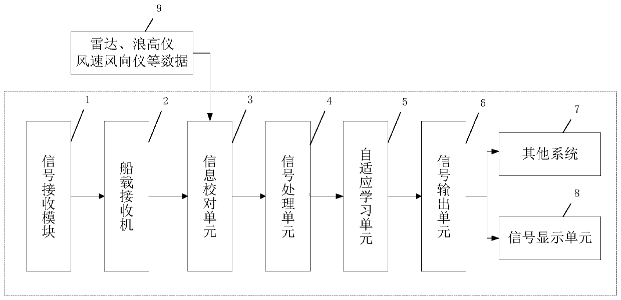
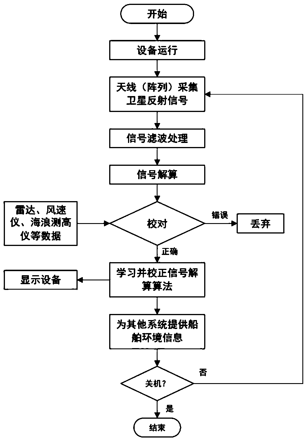
[0024] Such as figure 1 A ship navigation environment information collection and redundant control system based on shipborne GNSS-R is shown, including a signal receiving module, a shipboard receiver, a signal processing unit, an information proofreading unit, an adaptive learning unit, a signal output unit and Signal display unit.

[0025] The signal receiving module is used to receive GNSS-R reflection signals on the sea surface, where the GNSS-R reflection signals include specular reflection signals, diffuse reflection signals and sea clutter signals, where the sea clutter signals are caused by the reflection of random waves on the signal, and will interfere with subsequent signal proces...


PUM


Abstract

The invention discloses a ship navigation environment information collection and redundancy control system based on shipborne GNSS-R. According to the system of the invention, data information collected by a plurality of devices such as a radar, a wave height measuring instrument and an anemometer is acquired; the acquired information is the reflected signals of a satellite, the signal sources ofnavigation satellites are free, and therefore, all navigation satellites can be used as the signal sources of the system of the present invention; L-band waves used by the navigation satellites are not sensitive to rain and snow weather, and therefore, the system can realize sea surface condition all-weather and uninterrupted monitoring and provide accurate environmental data for ship navigation;since a signal receiving antenna is simple in structure and does not require mechanical moving parts such as a radar and an anemorumbometer, the service life of the signal receiving antenna is greatlyprolonged, and the data accuracy of the system after long-term use is ensured, and the system does not require frequent maintenance.

Description

technical field [0001] The invention relates to the technical field of ship navigation environment information perception, in particular to a ship navigation environment information collection and redundant control system based on shipborne GNSS-R. Background technique [0002] Today, with the continuous economic development, ocean-going ships are the main means of ocean transportation. With the development of large-scale, fast and automatic ships, the navigation safety of large-scale ships is also imminent. At present, the main problem faced by ships is the incomplete perception of environmental information during navigation, and the inability to respond to emergencies during navigation in a timely manner. As a ship, especially an ocean-going ship, as a large ship, its high inertia requires that the ship must detect danger as early as possible and take evasive actions in time. [0003] At present, the sensors used by ships to perceive the navigation environment include rad...

Claims


Application Information

Patent Timeline
IPC IPC(8): G01S19/14G01S13/02G01P5/00G01P13/02G01C5/00G01C21/00B63B49/00
CPCY02A90/10
Inventor 李颖韩周周杨振柳
Owner DALIAN MARITIME UNIVERSITY
Learn More