Method for extracting elevation of height measuring foot point through CryoSat-2 SARIn mode L1b level waveform data

A waveform data and high foot point technology, applied in the field of satellite altimetry data processing, can solve the problems of missing satellites, poor DEM acquisition accuracy, and low resolution, and achieve the goal of increasing the threshold, avoiding low unwrapping accuracy, and high resolution Effect

Active Publication Date: 2019-06-04
WUHAN UNIV
View PDF8 Cites 2 Cited by
  • Summary
  • Abstract
  • Description
  • Claims
  • Application Information

AI Technical Summary

Problems solved by technology

In October 2005, ESA launched the CryoSat satellite. Unfortunately, due to the failure of the launch vehicle, the satellite disappeared before entering orbit.
However, the traditional method of extracting ice sheet elevation based on satellite altimetry foot points cannot give full play to the advantages of the SARIn model, and cannot fundamentally solve the legacy problems of poor DEM acquisition accuracy and low resolution in the Antarctic continental margin region

Method used


Image

  • Method for extracting elevation of height measuring foot point through CryoSat-2 SARIn mode L1b level waveform data
  • Method for extracting elevation of height measuring foot point through CryoSat-2 SARIn mode L1b level waveform data
  • Method for extracting elevation of height measuring foot point through CryoSat-2 SARIn mode L1b level waveform data

Examples


Embodiment Construction

[0031] In order to make the object, technical solution and advantages of the present invention more clear, the present invention will be further described in detail below in conjunction with the examples. It should be understood that the specific embodiments described here are only used to explain the present invention, not to limit the present invention.

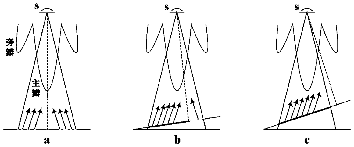
[0032] Such as figure 1 As shown, when the ground is relatively flat, the ground echo signal of CryoSat-2 SARIn mode originates from the sub-satellite point, and the echo intensity on both sides of the sub-satellite point is equivalent and has the same magnitude when the pulse transmission pointing deviation is not considered, as shown in figure 1 (a), the interference phase will produce ambiguity, and the interference condition is not met at this time. However, when the terrain fluctuates, POCA will deviate from the sub-satellite point, and the original balance of left and right echo signal strength will also be broken. ...


PUM


Abstract

The method discloses a method for extracting an elevation of a height measuring foot point through CryoSat-2 SARIn mode L1b level waveform data. The method comprises the following steps of 1) extracting echo coherence and differential phase information from the CryoSat-2 SARIn mode L1b level data; 2) carrying out smoothing processing on echo coherence and differential phase data; 3) carrying out threshold segmentation according to echo coherence, and taking an area where the coherence is greater than a threshold as an alternative area; 4) merging the alternative areas to obtain an effective differential phase to be unwrapped; 5) carrying out relative phase unwrapping in a time delay direction; 6) calculating an three-dimensional coordinate of an elevation point through a differential phase;7) converting a reference coordinate system; and 8) carrying out absolute phase unwrapping based on an external DEM. In the invention, a high-precision height measuring foot point elevation can be obtained from L1b level data; compared with L2 level data released by ESA, there is a larger foot point coverage density, and the digital elevation model with a higher resolution can be acquired to obtain a finer terrain.

Description

technical field [0001] The invention relates to a satellite altimetry data processing technology, in particular to a method for extracting the height of an altimetry foot point through L1b level waveform data of a CryoSat-2 SARIn mode. Background technique [0002] The mass loss of glaciers is often considered as one of the early catastrophes caused by global warming, and the change of mass balance of glaciers is an important factor affecting global climate and sea level. As climate change becomes more apparent, there is an urgent need to understand how glaciers on Earth's surface, especially in polar regions, are changing. The emergence of satellite altimetry technology has changed the way people observe the polar regions. Based on high-precision satellite altimetry observations, we have the ability to systematically conduct scientific research related to the polar regions. Over the past few decades, satellite altimetry technology has been widely used in ice sheet topograp...

Claims


Application Information

Patent Timeline
Patent Type & Authority Applications(China)
IPC IPC(8): G01S13/90G01S7/41
Inventor 周春霞墙强付正
Owner WUHAN UNIV
Why Eureka
Try Eureka