Domain Adaptive Remote Sensing Image Classification Algorithm Based on Unsupervised Manifold Alignment

A domain-adaptive, remote sensing image technology, applied in computing, computer parts, instruments, etc., can solve the problems of time-consuming and laborious manual labeling, inability to effectively meet the classification accuracy, lack of remote sensing image data, etc. Effect

Inactive Publication Date: 2021-04-27
TIANJIN UNIV
View PDF8 Cites 0 Cited by
  • Summary
  • Abstract
  • Description
  • Claims
  • Application Information

AI Technical Summary

Problems solved by technology

Due to the lack of data and labor-intensive manual labeling of remote sensing images, semi-supervised classification algorithms and supervised classification algorithms cannot effectively meet the requirements of classification accuracy. At this time, unsupervised image classification algorithms are the best choice
[0004] Using marked similar images to train classifiers for images to be classified is a generally applicable method in the field of image classification. With the development of image classification technology, many times the images to be classified cannot obtain enough images due to their fields or actual conditions. Labeled images are used as the training set, at this time it is difficult to complete the classification task using (semi-)supervised classification algorithms

Method used


Image

  • Domain Adaptive Remote Sensing Image Classification Algorithm Based on Unsupervised Manifold Alignment
  • Domain Adaptive Remote Sensing Image Classification Algorithm Based on Unsupervised Manifold Alignment
  • Domain Adaptive Remote Sensing Image Classification Algorithm Based on Unsupervised Manifold Alignment

Examples


Embodiment Construction

[0029] The technical solutions of the present invention will be further described in detail below in conjunction with examples.

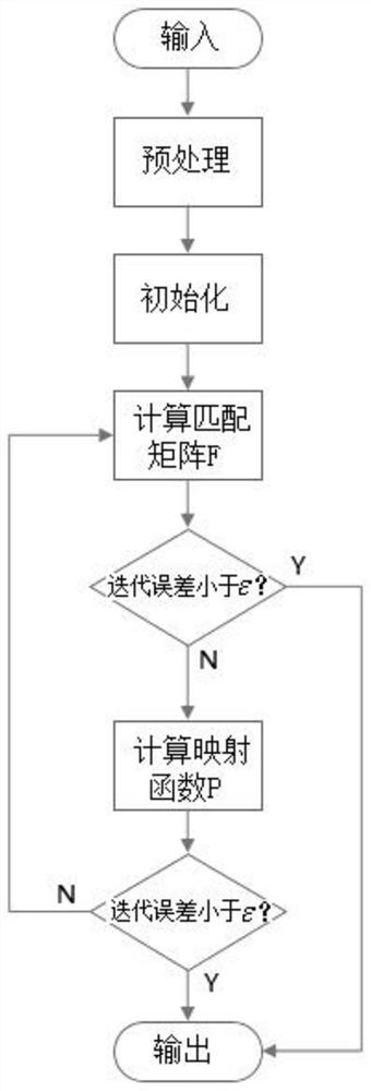
[0030] Such as figure 1 As shown, it is a schematic diagram of the overall flow of the domain adaptive remote sensing image classification algorithm based on unsupervised manifold alignment of the present invention. Specific steps are as follows:

[0031] Step 1. Perform preprocessing including normalization and pixel-by-pixel information reordering on the remote sensing data set, in which global protection rather than local protection is adopted for the data manifold; the specific process is: for the source domain data X and the target Domain data Z, constructing the overall data manifold instead of the local data manifold, the data points in the source domain (or target domain) are established by establishing a global edge weight connection graph, each point is connected to the nearest few points around, and Assign weights to each edge;

[0032...


PUM


Abstract

The invention discloses a domain-adaptive remote sensing image classification algorithm based on unsupervised manifold alignment. In step (1), the remote sensing data set is preprocessed including normalization and pixel-by-pixel information reordering, wherein the data flow is The shape adopts global protection; step (2), initialization; step (3), defining the overall objective function; step (4), adopting an alternate iterative method to optimize and solve the above-mentioned overall objective function, to obtain the matching matrix F, the mapping function P X and P Z , to classify data from the target domain. Compared with the prior art, the present invention has higher adaptability and has great advantages compared with the manual method.

Description

technical field [0001] The invention relates to the technical field of digital remote sensing image processing, in particular to a domain adaptive remote sensing image classification algorithm. Background technique [0002] The remote sensing image classification is to use the computer to select and analyze the spatial information, spectral information and geometric information of various objects in the collected remote sensing images, so as to obtain the characteristic image of interest, and then classify each pixel in the characteristic image according to a certain A rule or algorithm is divided into different categories, so as to obtain the corresponding ground object information and realize image classification. [0003] At present, the algorithms for remote sensing image classification are mainly divided into three categories, namely supervised classification algorithms, semi-supervised classification algorithms and unsupervised classification algorithms. Due to the la...

Claims


Application Information

Patent Timeline
Patent Type & Authority Patents(China)
IPC IPC(8): G06K9/62G06K9/00
Inventor 周圆金斗杜晓婷张天昊
Owner TIANJIN UNIV
Why Eureka
Try Eureka