A method and system for extracting the planting distribution of specific crop production areas in the world

A technology for crops and main production areas, applied in the field of agricultural remote sensing, can solve problems such as difficult to reflect the phenological characteristics of crops, difficult to distinguish between multiple types of crops, and low efficiency of analysis and extraction, so as to facilitate sample selection, reduce impact, and improve extraction efficiency effect

Active Publication Date: 2021-10-08
武汉珈和科技有限公司
View PDF4 Cites 0 Cited by
  • Summary
  • Abstract
  • Description
  • Claims
  • Application Information

AI Technical Summary

Problems solved by technology

[0003] Remote sensing technology can provide effective monitoring for large-scale crop planting. At present, images with medium-to-high spatial resolution and high temporal resolution can better overcome the problem of mixed pixels in low-resolution remote sensing images. Low, it is difficult to reflect the phenological characteristics of crop dynamic changes, and it is difficult to distinguish multiple crop types with similar phenological periods in the same region for crops on a global scale
Therefore, it is necessary to use low-to-medium resolution multi-time series data for analysis. When using supervised classification methods for low-to-medium-resolution data, a lot of manual experience and sample selection time are required, and the efficiency of analysis and extraction is low.

Method used


Image

  • A method and system for extracting the planting distribution of specific crop production areas in the world
  • A method and system for extracting the planting distribution of specific crop production areas in the world

Examples


Embodiment 1

[0025] see figure 1 , a schematic flowchart of a method for extracting the planting distribution of a specific global crop main production area provided by an embodiment of the present invention, including:

[0026] S101. Acquire multi-temporal data of MODIS data with medium and low resolution, generate time series NDVI images, perform S-G filtering on the images, and filter the images according to the phenological stages of specific crops to generate new NDVI images;

[0027] The low-to-medium resolution MODIS data refers to remote sensing data used for regional vegetation coverage, which is obtained by a spectral imager mounted on a satellite. The multi-temporal data refers to the characteristic data of remote sensing images in time series. Through multi-temporal Data, the time-series change curve of crop NDVI can be obtained. Optionally, by analyzing the time-series change curves of crop NDVI, the growth curves of crops in different regions can be obtained.

[0028] The S...

Embodiment 2

[0042] The above mainly describes a method for extracting the planting distribution of a specific global crop production area, and a system for extracting the planting distribution of a specific global crop production area will be described in detail below.

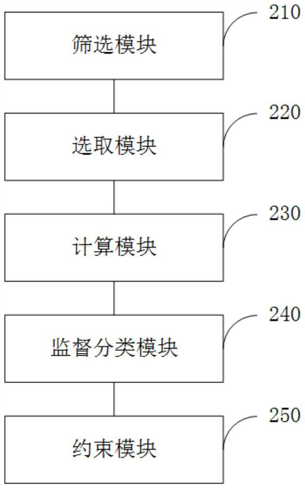
[0043] figure 2 It shows a structural diagram of an embodiment of a system for extracting the planting distribution of a specific global crop main production area in an embodiment of the present invention, and the system includes:

[0044]Screening module 210: used to acquire multi-temporal data of MODIS data with medium and low resolution, after generating time series NDVI images, perform S-G filtering on the images, and filter the images according to the phenological period of specific crops to generate new NDVI images ;

[0045] Selection module 220: used to perform principal component transformation on the new NDVI image, and select a preset number of principal components as the input image for supervised classifica...


PUM


Abstract

The invention discloses a method and a system for extracting the planting distribution of a specific global crop main production area, which are used in the field of agricultural remote sensing. The method provided by the present invention includes: acquiring multi-temporal data of MODIS data with medium and low resolution, generating time-series NDVI images, performing S-G filtering on the images, and screening the images according to the phenological periods of specific crops to generate new NDVI images image; carry out principal component transformation to it, select the principal component as the input image of supervised classification; obtain the sample of the specific crop by calculating the root mean square error of the growth curve of the NDVI image and the standard growth curve; call the support vector machine method to input The images are supervised and classified, and the supervised classification results are constrained. The present invention obtains the growth curve by analyzing the NDVI time-series change curve of a specific crop, thereby facilitating the selection of samples, reducing the influence of manual experience and the time consumption of sample selection. The extraction efficiency of crop planting distribution can be improved, and the accuracy of extraction can be improved at the same time.

Description

technical field [0001] The present invention relates to the field of agricultural remote sensing, in particular to a method and system for extracting the planting distribution of specific agricultural crops in the world. Background technique [0002] Understanding the planting distribution of crops can provide data reference and guidance for agricultural development. With the development of modern technology, it is aimed at a wide range of crop planting distribution. Traditional field surveys have been gradually replaced by remote sensing monitoring. Remote sensing monitoring is the long-distance detection of electromagnetic wave radiation and reflection characteristics through telemetry instruments on artificial satellites and other equipment. [0003] Remote sensing technology can provide effective monitoring for large-scale crop planting. At present, images with medium-to-high spatial resolution and high temporal resolution can better overcome the problem of mixed pixels ...

Claims


Application Information

Patent Timeline
Patent Type & Authority Patents(China)
IPC IPC(8): G06K9/00G06K9/62
CPCG06V20/188G06F18/2411
Inventor 杨泽宇
Owner 武汉珈和科技有限公司
Why Eureka
Try Eureka