A method, system and storage medium for tracking and monitoring sea ships

A ship and subsystem technology, applied in character and pattern recognition, image analysis, instruments, etc., can solve problems such as monitoring blind spots, low height, and radar detection results, and achieve the effect of increasing image size and enlarging the field of view

Active Publication Date: 2022-04-05
SHENZHEN JINRUN IND
View PDF7 Cites 0 Cited by
  • Summary
  • Abstract
  • Description
  • Claims
  • Application Information

AI Technical Summary

Problems solved by technology

[0009] 4) The detection and tracking of targets with low speed, low altitude and small size has always been a difficult problem in the radar field
[0010] 5) Interference conditions such as sea clutter, hidden piles, and waves can easily affect the detection results of the radar
[0011] 6) The nearby hills, buildings, etc. are blocked, resulting in monitoring blind spots
[0012] 7) In areas where the radar distance is relatively close, the monitoring effect is not good
[0013] 8) Two ships, when the distance is close, can be mistaken for one ship

Method used


Image

  • A method, system and storage medium for tracking and monitoring sea ships

Examples


Embodiment Construction

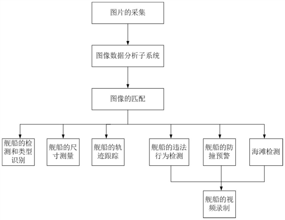
[0088] Such as figure 1 As shown, the present invention discloses a method for tracking and monitoring sea ships, comprising the following steps:

[0089] The picture collection step: receiving the picture collected by the aerial photography of the fixed-wing UAV;

[0090] Image data analysis subsystem steps: The image data analysis subsystem is an advanced deep learning pattern recognition system deployed on the cloud platform at the back end. The location of the ship, identifying the type of the ship, and measuring its size, using two consecutive frames of high-altitude images before and after, by matching the images of the ship, it is also possible to track the ship's trajectory;

[0091] Image data analysis subsystem in the back-end cloud platform: the fixed-wing UAV does not have a computing unit with large computing power, so the high-altitude high-definition pictures it takes are sent to the rear cloud computing platform. There is a high-speed 4G or 5G communication s...


PUM


Abstract

The present invention provides a method for tracking and monitoring ships on the sea surface, comprising the following steps: picture collection step: receiving pictures collected by aerial photography of fixed-wing unmanned aerial vehicle; image data analysis subsystem step: image data analysis subsystem is the latter The terminal is based on the advanced deep learning pattern recognition system deployed on the cloud platform. The system receives the pictures collected by the aerial photography of the fixed-wing UAV, and can detect the position of each ship from the pictures, identify the type of the ship, and calculate Its size, using two consecutive high-altitude images before and after, can also track the ship's trajectory by matching the image of the ship. The beneficial effects of the present invention are: 1. The size of the ship can be known; 2. In addition to moving targets, stationary targets can also be detected; 3. The unmanned aerial vehicle is flying and can control the detection area; 4. The speed and height of the target , Size, has little effect on tracking; 5. The effects of sea clutter, hidden piles, and waves completely disappear.

Description

technical field [0001] The present invention relates to marine informatization, computer vision and artificial intelligence, and in particular to a method, system and storage medium for tracking and monitoring sea ships. Background technique [0002] Oceans occupy most of the Earth's surface area. Human activities cannot be separated from the ocean. In recent years, with the country's increasing emphasis on marine rights and interests, marine informatization has become more and more important. By building a marine information system, various industries such as fishery, coast guard, national defense, ocean navigation, meteorology, ecological environment monitoring, environmental protection, seawater planting, etc. can benefit greatly. [0003] In terms of monitoring of coastal areas, the monitoring of ships in a certain sea area is a matter of great concern to the coast guard, maritime affairs, fisheries and other departments. The current mainstream tracking and monitoring...

Claims


Application Information

Patent Timeline
Patent Type & Authority Patents(China)
IPC IPC(8): G06V20/13G06V10/44G06V10/74G06V10/25G06T7/246G06T7/254
CPCG06T7/246G06T7/254G06V20/13G06V10/25G06V10/44G06F18/22
Inventor 鲁峦峰吴继云杨浩龙玉标
Owner SHENZHEN JINRUN IND
Why Eureka
Try Eureka