
A method and a system for quickly drawing super-large-scale spatial data

A spatial data, super-large-scale technology, applied in the field of geospatial information, can solve the problems of long downsizing processing time, low efficiency, long data processing time, etc., and achieve the effect of avoiding large data processing volume, improving mapping efficiency, and simple calculation process.

Active Publication Date: 2019-03-01
NAT GEOMATICS CENT OF CHINA
View PDF12 Cites 12 Cited by
  • Summary
  • Abstract
  • Description
  • Claims
  • Application Information

AI Technical Summary

Problems solved by technology

With the growth of data volume and the expansion of mapping scope, the performance of spatial data mapping software is not enough to meet the mapping requirements of massive spatial data; at the same time, with the increase of original data, the workload of map data reduction increases accordingly, and the reduction processing consumes The time is too long, which makes the efficiency of traditional map drawing methods relatively low. When dealing with large-scale geospatial data mapping, it will face many bottlenecks, and it is difficult to meet the objective needs of large-scale spatiotemporal geographic data rapid mapping.
[0003] In view of the above-mentioned existing spatial data mapping methods, data processing takes too long and the efficiency is low, and no effective solution has been proposed

Method used


Image

  • A method and a system for quickly drawing super-large-scale spatial data
  • A method and a system for quickly drawing super-large-scale spatial data
  • A method and a system for quickly drawing super-large-scale spatial data

Examples


Embodiment Construction

[0024] In order to make the purpose, technical solutions and advantages of the embodiments of the present invention clearer, the technical solutions of the present invention will be clearly and completely described below in conjunction with the accompanying drawings. Obviously, the described embodiments are part of the embodiments of the present invention, not all of them. the embodiment. Based on the embodiments of the present invention, all other embodiments obtained by persons of ordinary skill in the art without making creative efforts belong to the protection scope of the present invention.

[0025] Spatial data mapping is an intuitive means of expressing geographic information. Traditional spatial data mapping is realized by using geographic information mapping software. The mapping method includes the following main steps: (1) data loading, loading basic data of mapping in geographic information mapping software; (2) content determination, determining the theme and cont...


PUM


Abstract

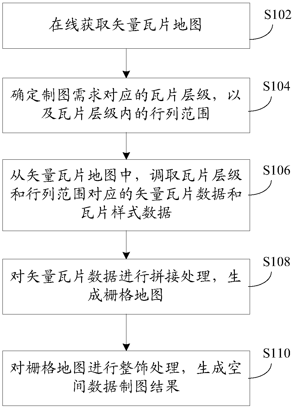
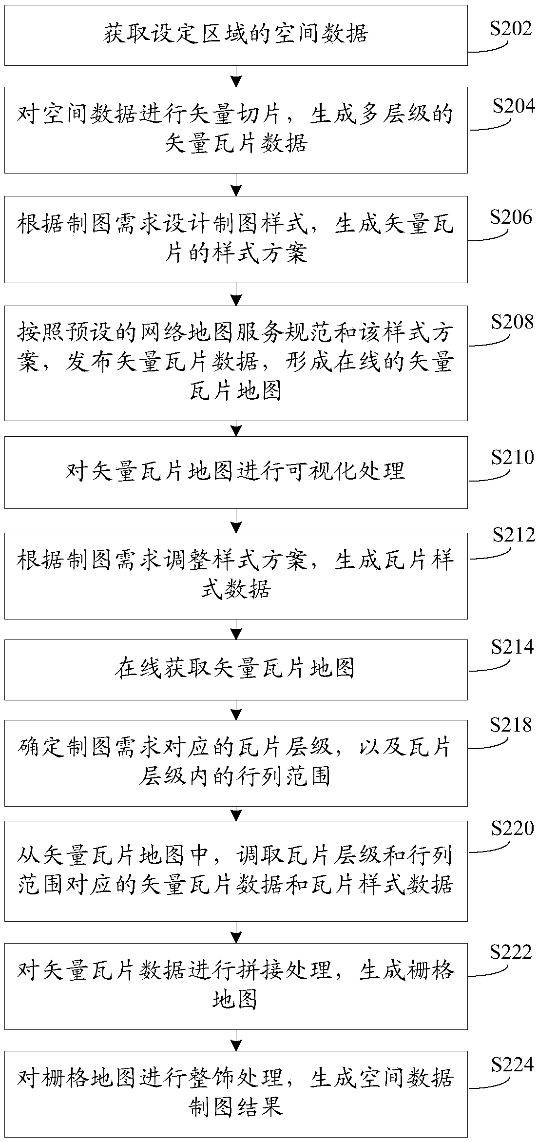
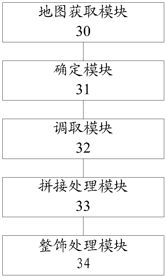
The invention provides a rapid mapping method and system for super-large-scale spatial data. The method comprises the following steps: obtaining a vector tile map on line, wherein the vector tile mapcomprises vector tile data and tile style data; determining tile hierarchies corresponding to the drawing requirements and row and column ranges in the tile hierarchies; Retrieving vector tile data and tile style data corresponding to the tile levels and the row and column ranges from the vector tile map; splicing the vector tile data to generate a grid map; and trimming the grid map to generate aspatial data drawing result. According to the method, drawing is carried out based on the online vector tile map, real-time dynamic rendering of the drawing style is carried out according to the drawing requirement, the calculated amount is only related to the retrieved tile level and range, the calculation process is simple, the problem that the data processing amount is large due to the fact that traditional drawing is firstly shrunk and then drawn is solved, and the spatial data drawing efficiency is improved.

Description

technical field [0001] The invention relates to the technical field of geospatial information, in particular to a method and system for fast mapping of ultra-large-scale spatial data. Background technique [0002] With the gradual development of earth observation, satellite remote sensing, ecological assessment, and land supervision in the direction of macroscopic, dynamic, and refined, the generation and update speed of basic geographic information data is getting faster and higher, and the accuracy is getting higher and higher, thus forming a massive Multi-period, high-precision geographic information results data. With the growth of data volume and the expansion of mapping scope, the performance of spatial data mapping software is not enough to meet the mapping requirements of massive spatial data; at the same time, with the increase of original data, the workload of map data reduction increases accordingly, and the reduction processing consumes The time is too long, whi...

Claims


Application Information

Patent Timeline
IPC IPC(8): G06F16/56G06F16/188G06T3/40G06T11/20
CPCG06T3/4038G06T11/206
Inventor 高崟刘建军张元杰
Owner NAT GEOMATICS CENT OF CHINA
Learn More