A method for deploying map tile service and path planning in an intranet

A map tile and path planning technology, applied in software deployment, geographic information database, structured data retrieval, etc., can solve problems such as violation of commercial map user agreement, poor user experience, etc., to improve indexing efficiency and increase rendering speed , Improve the effect of user experience

Inactive Publication Date: 2019-02-26
ANHUI ZHONGXIN SOFTWARE
View PDF6 Cites 5 Cited by
  • Summary
  • Abstract
  • Description
  • Claims
  • Application Information

AI Technical Summary

Problems solved by technology

[0003] At present, there are many commercial electronic maps on the Internet, and online API open service interfaces are provided. By accessing these JavaScript interfaces online, you can use map services provided by map providers such as Baidu and AutoNavi, but there is a prerequisite , that is, it must be connected to the Internet. For the situation where the Internet cannot be connected, the traditional method is to offline the tile data of each commercial map, deploy a set of HTTP request response system in the intranet, and return the corresponding The tile map, this method violates the user agreement of the commercial map; the second is that the user experience is very bad

Method used


Image

  • A method for deploying map tile service and path planning in an intranet

Examples


Embodiment Construction

[0021] In order to make the technical means, creative features, goals and effects achieved by the present invention easy to understand, the technical solutions in the embodiments of the present invention will be clearly and completely described below in conjunction with the accompanying drawings in the embodiments of the present invention. Obviously, the The described embodiments are only some, not all, embodiments of the present invention. Based on the embodiments of the present invention, all other embodiments obtained by persons of ordinary skill in the art without creative efforts fall within the protection scope of the present invention.

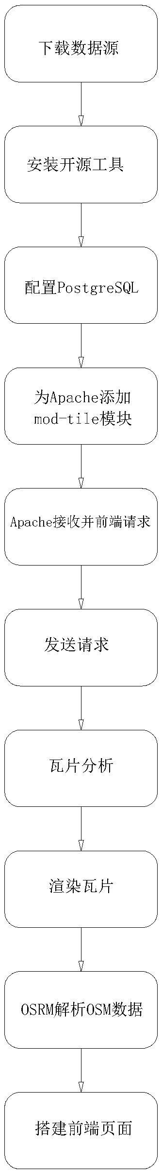
[0022] Such as figure 1 A method for deploying map tile services and path planning in an intranet includes the following steps:

[0023] Step 1. Download the data source: Download the OpenStreetMap spatial vector data source. OpenStreetMap is an open source map data service created and edited by the public. It uses the power of the pub...


PUM


Abstract

The invention relates to the technical field of electronic maps, in particular to an intranet deployment map tile service and a path planning method, includes such steps as downloading data source, installing open source tools, configuring PostgreSQL, adding mod_tile module for Apache, Apache receiving and front-end request, sending request, tile analysis, rendering tile, OSRM parsing OSM data, and building front-end page. The invention has the advantages of: Using vector space data of OpenStreetMap, the mod_tile module of apache is used as the map server, the OSRM serves as a path plan engine, using renderd and mapnik as map renderers, the leaflet serves as the front-end map frame, a perfect map service is built in intranet. After deploying intranet map service, it can achieve the similareffect of commercial Internet map in intranet, including navigation and path planning, and improve the user experience. PostgreSQL database is used to store spatial vector data, which greatly increases the rendering speed of mapnik.

Description

technical field [0001] The invention relates to the technical field of electronic maps, in particular to a method for deploying map tile services and path planning in an intranet. Background technique [0002] With the development of people's travel needs and data visualization, GIS has penetrated into all aspects of life. From the birth of Google Maps in 2005 to the flourishing of electronic maps, electronic maps have been fully integrated into our lives. Various industries such as navigation, positioning, express delivery, and public security all rely on the convenience brought by electronic maps. [0003] At present, there are many commercial electronic maps on the Internet, and online API open service interfaces are provided. By accessing these JavaScript interfaces online, you can use map services provided by map providers such as Baidu and AutoNavi, but there is a prerequisite , that is, it must be connected to the Internet. For the situation where the Internet cannot...

Claims


Application Information

Patent Timeline
Patent Type & Authority Applications(China)
IPC IPC(8): G06F8/61G06F16/29
CPCG06F8/61
Inventor 周先东章文友朱静轩
Owner ANHUI ZHONGXIN SOFTWARE
Why Eureka
Try Eureka