A high-efficiency display method and device of dynamic legend in webgis environment

A display method and dynamic map technology, applied in the field of geographic information, can solve the problems of slow calculation speed, delayed user interface legend refresh, poor user experience, etc., to reduce read and write access and improve overall performance.

Active Publication Date: 2021-01-22
吉奥时空信息技术股份有限公司
View PDF9 Cites 0 Cited by
  • Summary
  • Abstract
  • Description
  • Claims
  • Application Information

AI Technical Summary

Problems solved by technology

[0006] In view of the above problems, the purpose of the present invention is to provide a method and device for efficiently displaying dynamic legends in the WebGIS environment, aiming at solving the problem of easy calculation due to the large amount of data in the map range when using the existing technical solutions. The speed is slow, causing the legend refresh delay on the user interface, causing technical problems such as poor user experience

Method used


Image

  • A high-efficiency display method and device of dynamic legend in webgis environment
  • A high-efficiency display method and device of dynamic legend in webgis environment
  • A high-efficiency display method and device of dynamic legend in webgis environment

Examples


Embodiment 1

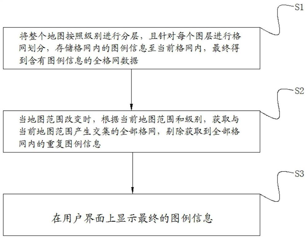
[0036]Such asfigure 1 As shown, the method for efficiently displaying dynamic legends in a WebGIS environment provided by the embodiment of the present invention includes the following steps:

[0037]Step S1. The entire map is layered according to levels, and grids are divided for each layer, and the legend information in the grid is stored in the current grid, and finally full grid data containing the legend information is obtained.

[0038]Currently maps are all hierarchical structures, and different levels correspond to different scales. The purpose of this step is to divide each layer into a grid and store legend information in the grid. Specifically, the specific implementation process of this step is as follows:

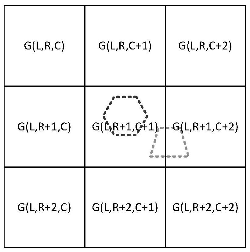
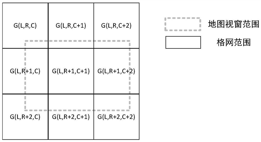
[0039]S11. Divide the entire map into several levels of pyramids according to the quadtree pattern. Each level of the pyramid is a layer, and each level of the pyramid is divided into a number of grids arranged horizontally and vertically. Each grid passes through the level, ...

Embodiment 2

[0066]Such asFigure 4As shown, the present invention provides an efficient display device for dynamic legends in a WebGIS environment to complete the efficient display method for dynamic legends in a WebGIS environment provided by the invention. The efficient display device for dynamic legends in a WebGIS environment includes

[0067]Preprocessing unit: used to store legend information in grid data;

[0068]Legend real-time calling unit: when the map range changes, it is used to obtain all grids that intersect with the current map range, and remove duplicate legend information in all grids;

[0069]Interface display unit: used to display the final legend information.

[0070]As a specific structure of the preprocessing unit, it includes:

[0071]The grid division module is used to divide the entire map into several levels of pyramids according to the quadtree mode. Each level of the pyramid is a layer, and each level of the pyramid is divided into several horizontal and vertical grids, and each gr...


PUM


Abstract

The invention is applicable to the field of geographic information technology and provides an efficient display method and device for dynamic legends in a WebGIS environment. The method comprises: layering an entire map according to a level, dividing a grid for each layer, storing legend information in the grid into a current grid, and finally obtaining full-grid data containing legend information; when the map range is changed, obtaining all grids intersecting with the current map range according to the current map range and level, and eliminating the duplicate legend information in all grids; displays the final legend information on the user interface. Through the above preprocessing process, all grids contain the symbolic information of each layer in the map, which effectively improvesthe performance of dynamic legend calculation in the case of too much data in the map, reduces the read-write access to the data itself, and improves the overall performance of the system.

Description

Technical field[0001]The invention belongs to the field of geographic information technology, and particularly relates to a method and device for efficiently displaying dynamic legends in a WebGIS environment.Background technique[0002]In the geographic information system, the legend is an indispensable part of the important elements in the system, used to centrally describe the graphics displayed on the map, so that the viewer can easily understand the meaning of the graphic symbols.[0003]The number and style of legends are generally clarified during the map making process. When the legend function is called in the system, all legends will be displayed directly. When there are many legends, the legend interface will appear messy and disorderly. In the prior art solutions, some people have proposed the use of dynamic display methods. According to the actual elements displayed in the current map field of view, the legends that need to be displayed are determined in real time, and the ...

Claims


Application Information

Patent Timeline
Patent Type & Authority Patents(China)
IPC IPC(8): G06F16/29G06F9/451
CPCG06F9/451
Inventor 李论罗慕笔杨玲席胜吴昊
Owner 吉奥时空信息技术股份有限公司
Why Eureka
Try Eureka