A Terrain Correction Method for Meter-Wave Radar Based on Digital Elevation Model

A digital elevation model and meter wave radar technology, applied in radio wave measurement systems, instruments, etc., can solve problems such as large computational load, difficult terrain correction, and reduced angle measurement accuracy, and achieve the effect of simplifying the correction process and reducing the correction cost.

Active Publication Date: 2022-08-02
XIDIAN UNIV
View PDF5 Cites 0 Cited by
  • Summary
  • Abstract
  • Description
  • Claims
  • Application Information

AI Technical Summary

Problems solved by technology

[0002] Meter wave radar, also known as very high frequency radar, belongs to long wave radar, so it has the advantages of long detection distance, anti-stealth and anti-interference; but at the same time, because of the wide beam, on the one hand, the direct wave and the reflected wave are in the same beam Indistinguishable; on the other hand, there is the problem of beam hitting the ground, which leads to lobe splitting, and the estimation of target elevation angle is biased at low elevation angles; in view of the above-mentioned multipath effect problems that mainly exist in meter wave radar, through a large number of analysis and research, mainly from the algorithm Improvement and algorithm correction are two ways to solve this problem; specifically, on the one hand, improve and optimize the angle measurement algorithm in order to obtain higher-precision angle measurement results; on the one hand, study the influence of terrain fluctuations on angle measurement, And analyze the specific influencing factors, propose a terrain compensation method, and correct the angle measurement error
[0003] Although the early angle and height measurement algorithm of radar can measure multiple targets, the formed lobes are wide, resulting in low angular resolution. When two targets are in the same beam width, they cannot be distinguished, resulting in angle measurement accuracy. In order to solve the problem of insufficient accuracy of low elevation angle estimation, two types of super-resolution algorithms, subspace algorithm and maximum likelihood algorithm, came into being. Multiple Signal Classification algorithm (Multiple Signal Classification, MUSIC) is a commonly used For subspace algorithms, the MUSIC algorithm requires that the signal subspace and the noise subspace have an orthogonal relationship, that is, the two must be incoherent. However, at low elevation angles, the Doppler frequency of the direct wave signal and the multipath signal received by the radar antenna are approximately The same means that the two signals have a coherent relationship, which leads to a decrease in the angle measurement accuracy of the MUSIC algorithm; the implementation process of the maximum likelihood algorithm (Maximum Likelihood, ML) requires a multi-dimensional search in the airspace, which leads to a large amount of calculation for the ML algorithm ; Although these two algorithms have high angular resolution, due to the large amount of calculation and low calculation efficiency, these two algorithms cannot meet the requirements of radar real-time processing signals
[0004] After long-term analysis and research, scholars have proposed a synthetic steering vector (Synthetic Steering Vector Maximum Likelihood, SVML) algorithm, which uses an equivalent spherical model, takes into account the curvature of the earth and the terrain information near the radar, and can accurately estimate the elevation angle of the target; In addition, scholars have also proposed an Alternate Projection (AP) algorithm, which does not depend on the terrain and can accurately calculate the elevation angle of the target, but there are problems such as large amount of calculation and uncertain convergence
[0005] In summary, it can be seen that although some existing super-resolution algorithms can solve the problem of multipath effects, they need to be matched with suitable terrain to accurately measure the target elevation angle; however, the current ADS-B (Automatic Dependent Surveillance-Broadcasting) technology is used in Terrain correction is difficult without civil aviation and high maneuverability

Method used


Image

  • A Terrain Correction Method for Meter-Wave Radar Based on Digital Elevation Model
  • A Terrain Correction Method for Meter-Wave Radar Based on Digital Elevation Model
  • A Terrain Correction Method for Meter-Wave Radar Based on Digital Elevation Model

Examples


Embodiment Construction

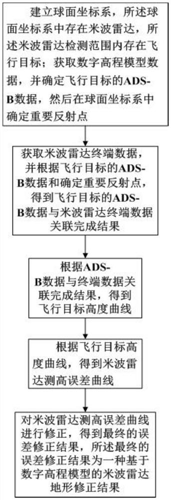
[0027] Step 1, format the ADS-B data and store it in the same array as the DEM data.

[0028] Determine the meter-wave radar, there is a flying target within the detection range of the meter-wave radar, and obtain the ADS-B data of the flying target. The data obtained after continuous monitoring of the flight process of the flight target, the ADS-B data of the flight target includes the flight number Num, time, latitude and longitude (ω, υ) and altitude real_H of the flight target; first, it will be obtained through ADS-B technology The ADS-B data of the flying target is converted into coordinates to obtain the distance and azimuth information of the flying target when the metric wave radar is used as the reference point.

[0029] Coordinate transformation first needs to establish a coordinate system such as figure 2 As shown, the spherical coordinate system oxy is established with the center of the earth O as the origin, in which the line passing through the center of the e...


PUM


Abstract

The invention discloses a metric wave radar terrain correction method based on a digital elevation model, which belongs to the technical field of metric wave radar signal processing. There is a flying target within the detection range of the metric wave radar; obtain the digital elevation model data, and determine the ADS‑B data of the flying target, and then determine the important reflection points in the spherical coordinate system; ‑B data and determine important reflection points, obtain the results of the correlation between the ADS‑B data of the flying target and the metric wave radar terminal data, and then obtain the altitude curve of the flying target; The metric wave radar altimetry error curve is corrected, and the final error correction result is obtained as a topographic correction result of the metric wave radar based on the digital elevation model.

Description

technical field [0001] The invention belongs to the technical field of metric wave radar signal processing, and particularly relates to a method for terrain correction of metric wave radar based on a digital elevation model, which is suitable for the research on the refinement of radar altimetry and angle measurement. Background technique [0002] Meter-wave radar, also known as VHF radar, belongs to long-wave radar, so it has the advantages of long detection distance, anti-stealth and anti-jamming. Indistinguishable; on the other hand, there is the problem of beam hitting the ground, which leads to lobe splitting, and the target elevation angle estimation is biased at low elevation angles; for the above-mentioned multipath effect problems that currently exist in metric wave radars, through a lot of analysis and research, mainly from the algorithm The problem is solved in two aspects: improvement and algorithm correction. Specifically, on the one hand, the algorithm of angle...

Claims


Application Information

Patent Timeline
Patent Type & Authority Patents(China)
IPC IPC(8): G01S7/40
CPCG01S7/40
Inventor 宋万杰张萌金莉
Owner XIDIAN UNIV
Why Eureka
Try Eureka