
Path planning device and method based on high-precision map

A path planning, high-precision technology, applied in the direction of measuring devices, road network navigators, instruments, etc., can solve the problems that are not suitable for automatic driving reference and cannot be divided into multiple lanes

Active Publication Date: 2018-12-11
WUHAN ZHONGHAITING DATA TECH CO LTD
View PDF5 Cites 18 Cited by
  • Summary
  • Abstract
  • Description
  • Claims
  • Application Information

AI Technical Summary

Problems solved by technology

[0003] Embodiments of the present invention at least provide a path planning method based on high-precision maps, which can solve the problem that in the prior art, only one basic driving path can be provided and the lane cannot be divided into multiple grid areas that can be passed. Questions suitable as further reference for autonomous driving

Method used


Image

  • Path planning device and method based on high-precision map
  • Path planning device and method based on high-precision map
  • Path planning device and method based on high-precision map

Examples


Embodiment 1

[0048] This embodiment provides a path planning method based on a high-precision map.

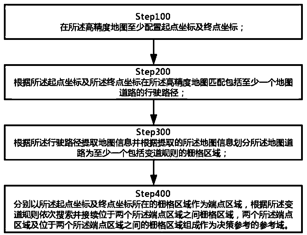
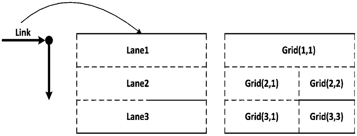
[0049] Through the method of this embodiment, the road data based on the high-precision map can be divided into at least one Grid, and the Grid between the starting point and the ending point of the path can be used as a decision-making reference for the decision-making layer; in order to achieve the aforementioned content, please refer to figure 1 .

[0050] Step100, mark the starting point coordinates and the ending point coordinates on the high-precision map according to the driving route;

[0051] Step 200. Match the driving path on the high-precision map according to the starting point coordinates and the ending point coordinates. The driving path can be a Link or a combination of at least two Links; details are as follows.

[0052] Step210, the coordinates of the starting point and the ending point are all located in the same Link; then directly use the Link as the driving path;

[...

Embodiment 2

[0074] It is considered that at least two or more reference domains may be obtained through searching. Compared with the first embodiment, the difference of this embodiment is Step400, specifically:

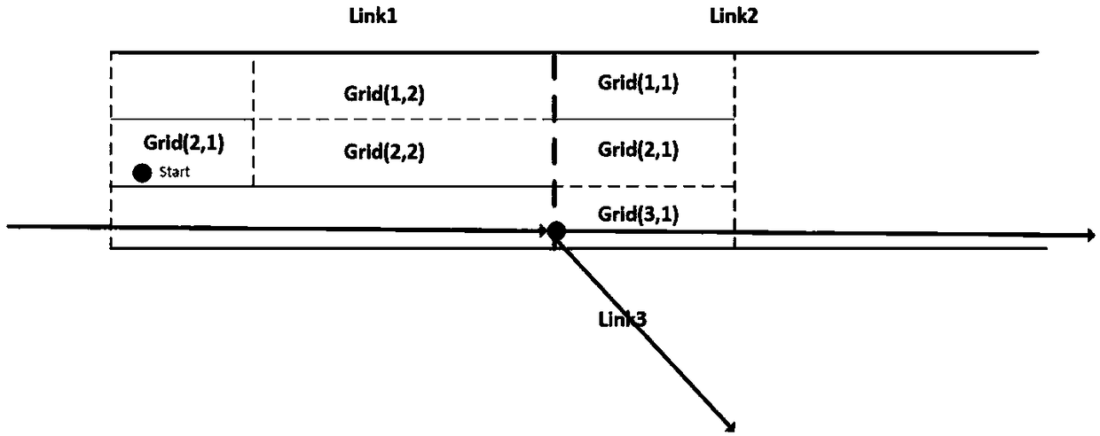
[0075] Step410, respectively take the Grid where the starting point coordinates and the ending point coordinates are located as the end point area, search and connect the Grid between the two end point areas in sequence according to the lane change rules, the two end point areas and the Grid between the two end point areas form at least two a reference domain;

[0076] Step420, extracting path information of all driving domains according to the high-precision map;

[0077] Step430. Select a reference domain as a decision-making reference according to the path information of the comparison driving domain.

[0078] Please refer to Figure 5 , the present embodiment provides a path planning device based on a high-precision map, including a map module, which establishes a high-pre...


PUM


Abstract

The invention discloses a path planning device and method based on a high-precision map; wherein the method comprises the steps: configuring at least a starting point coordinate and an ending point coordinate in a high-precision map; matching a driving path including at least a map road according to the starting point coordinate and the ending point coordinate on the high-precision map; extractingmap information according to the driving path and dividing the map road according to the extracted map information into one or more grid area including a path changing rule; respectively using the grid area in which the starting point coordinate and the ending point coordinate are located as a terminal point area, according to the path changing rule, successively searching and continuing the gridarea between two terminal point areas, wherein the two terminal point areas and the grid area between two terminal point areas constitute a reference field for decision reference. The path planning device and method based on high-precision map provided by the invention utilizes high precision map data to plan all grid areas for all references.

Description

technical field [0001] The present invention relates to the fields of active safety and automatic driving, in particular to a high-precision map-based path planning device and method. Background technique [0002] Lane-level route planning based on traditional maps and / or high-precision maps in the prior art can calculate at least one optimal driving route to meet driving needs. However, with the development of active safety and automatic driving technology, the demand for data types and content that can be provided on the driving path of automatic driving is increasing. In the prior art, only a basic driving path can be provided through lane-level path planning, which cannot meet the requirements of automatic on-board driving. Terminal decision-making needs. Contents of the invention [0003] Embodiments of the present invention at least provide a path planning method based on high-precision maps, which can solve the problem that in the prior art, only one basic driving ...

Claims


Application Information

Patent Timeline
IPC IPC(8): G01C21/34G01C21/20
CPCG01C21/20G01C21/3415
Inventor 石涤文郑武贞
Owner WUHAN ZHONGHAITING DATA TECH CO LTD
Learn More