A GIS-based method for site selection and optimization of concentrated residential areas in rural settlements

An optimization method and technology of residential areas, applied in the GIS field, can solve problems such as not considering the actual needs of residential areas, and achieve the effect of small distance cost, strong operability, and high precision

Active Publication Date: 2022-03-29
ANHUI UNIVERSITY OF ARCHITECTURE
View PDF7 Cites 0 Cited by
  • Summary
  • Abstract
  • Description
  • Claims
  • Application Information

AI Technical Summary

Problems solved by technology

Quantitative analysis is rare. For example, some scholars use the regional division characteristics of the weighted Voronoi diagram and use the influence degree as the weight to determine the influence range of rural residential areas, so as to clarify the relocation and retention of residential areas. However, the Vorinoi diagram is based on distance analysis and has no Consider the actual needs of the settlement

Method used


Image

  • A GIS-based method for site selection and optimization of concentrated residential areas in rural settlements
  • A GIS-based method for site selection and optimization of concentrated residential areas in rural settlements
  • A GIS-based method for site selection and optimization of concentrated residential areas in rural settlements

Examples


Embodiment Construction

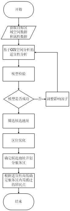
[0033] The technical solutions in the embodiments of the present invention will be clearly and completely described below with reference to the accompanying drawings in the embodiments of the present invention. Obviously, the described embodiments are only a part of the embodiments of the present invention, not all of the embodiments. The embodiments of the present invention, and all other embodiments obtained by those of ordinary skill in the art without creative work, fall within the protection scope of the present invention.

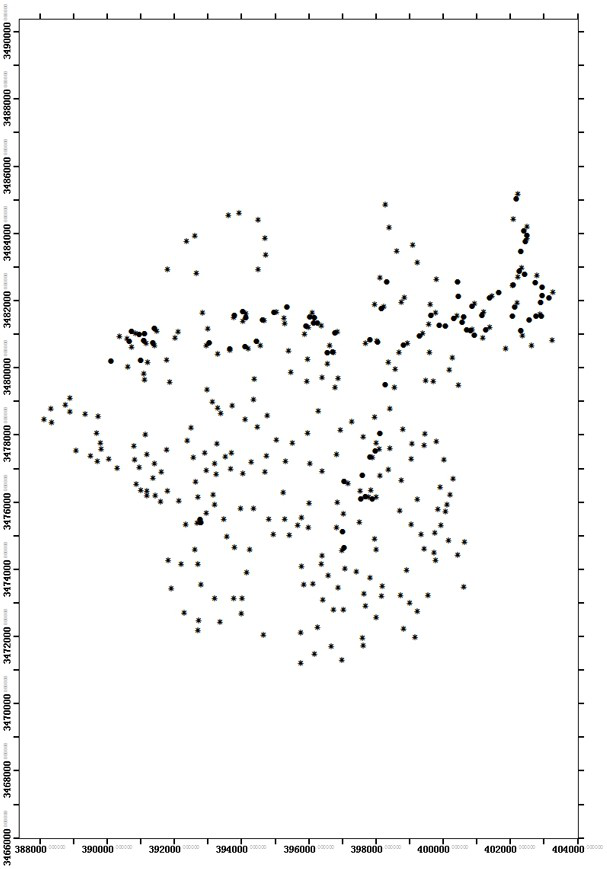
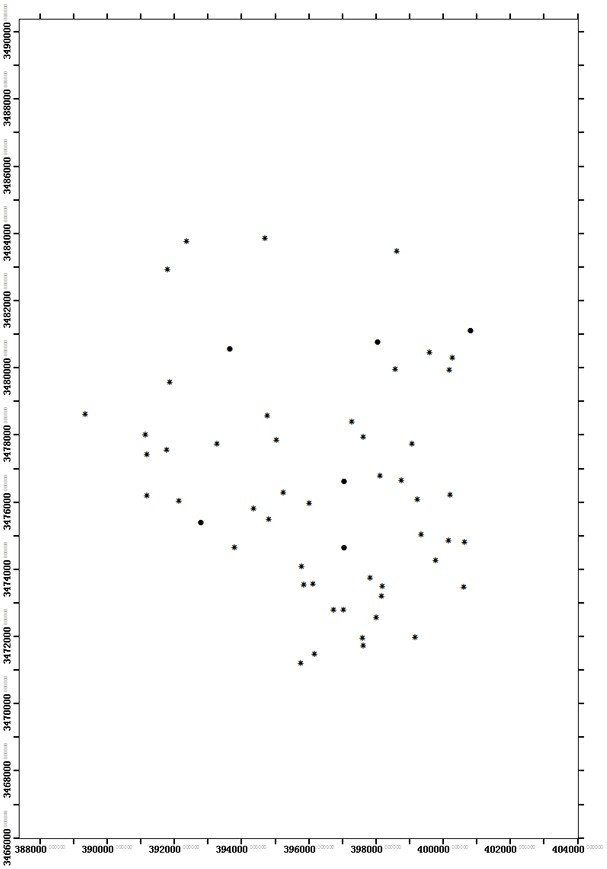
[0034] see Figure 1-3 , the present invention provides a kind of technical scheme:

[0035] A GIS-based method for site selection and optimization of concentrated residential areas in rural settlements. First, based on GIS, the spatial and attribute data of the target area are obtained, an information model is constructed to evaluate the land suitability of concentrated residential areas in rural settlements, and the land use planning is superimposed...


PUM


Abstract

The invention discloses a GIS-based site selection and optimization method for concentrated residential areas in rural residential areas. Firstly, the space and attribute data of the target area are obtained based on GIS, and an information amount model is constructed to evaluate the suitability of land for concentrated residential areas in rural residential areas. Use planning to allow construction areas to obtain candidate addresses, and set area size thresholds for screening, and then use the P-median problem model to optimize candidate addresses. The present invention uses GIS technology to build an information model, quantitatively evaluates the suitability of rural residential land use and selects a site, and uses the P-median problem model of integer linear programming to optimize the location, and can flexibly set candidate address requirements and site selection. As a result, the site was located; the candidate address was based on the actual road network, considering the daily labor needs of farmers after relocation, so that the distance cost was minimized, and it had the advantages of high precision and strong operability.

Description

technical field [0001] The invention relates to GIS technology, in particular to a GIS-based method for site selection and optimization of concentrated residential areas in rural settlements. Background technique [0002] Rural settlements are the main gathering form of farmers, and their external form and spatial structure are the result of their interaction with the surrounding natural environment, social economy, and human and land. Accurately grasping their internal laws has an important impact on the land consolidation work in rural settlements. . In recent years, many domestic scholars have discussed the relationship between the distribution of rural settlements and various influencing factors from the perspectives of natural environment, economic development and social culture, based on location theory, and have conducted research on the suitability of different types of rural settlements. Evaluation, and carry out layout optimization or zoning regulation, and analyz...

Claims


Application Information

Patent Timeline
Patent Type & Authority Patents(China)
IPC IPC(8): G06Q10/04G06F16/29G06Q50/26
CPCG06Q10/043G06Q50/26
Inventor 朱传华张勇解华明胡彦
Owner ANHUI UNIVERSITY OF ARCHITECTURE
Why Eureka
Try Eureka