
Method for constructing soil erosion coupling model in subtropical region

A subtropical, coupled model technology, applied in special data processing applications, instruments, electrical digital data processing, etc., can solve soil erosion, it is impossible to accurately predict and summarize the development status and development trend of regional soil erosion, soil erosion problems Can not simulate problems such as reflection, to achieve good applicability

Inactive Publication Date: 2018-09-04
GUANGZHOU INST OF GEOGRAPHY GUANGDONG ACAD OF SCI
View PDF2 Cites 8 Cited by
  • Summary
  • Abstract
  • Description
  • Claims
  • Application Information

AI Technical Summary

Problems solved by technology

[0002] Soil erosion (also known as erosion or soil erosion) is a phenomenon in nature, which means that the surface of the earth is constantly worn by external forces such as wind, water, and ice melting, and the surface soil, parent material, and rocks are subjected to various damages and damages. The phenomenon of movement, accumulation and loss of water itself, including soil erosion and water loss, in a narrow sense, "soil erosion" refers to the phenomenon of water erosion of surface soil, which causes damage and loss of water and soil resources and land productivity, affecting human and For the survival of other animals and plants, the subtropical zone is a climate zone on the earth. Generally, the subtropical zone is located in the temperate zone close to the tropics (approximately 23.5°N-40°N, 23.5°S-40°S). The subtropical climate is characterized by its The summer is similar to the tropics, but the winter is obviously colder than the tropics. The average temperature of the coldest month is above 0 degrees Celsius. The subtropical zone has an obvious rainy season, and the soil erosion is serious. The existing soil erosion problems cannot be simulated and reflected in a timely manner by the model, and there is no way to accurately estimate them. Infer and summarize the current situation and development trend of regional soil and water loss

Method used


Image

  • Method for constructing soil erosion coupling model in subtropical region
  • Method for constructing soil erosion coupling model in subtropical region

Examples


Embodiment Construction

[0030] The following will clearly and completely describe the technical solutions in the embodiments of the present invention with reference to the accompanying drawings in the embodiments of the present invention. Obviously, the described embodiments are only some, not all, embodiments of the present invention.

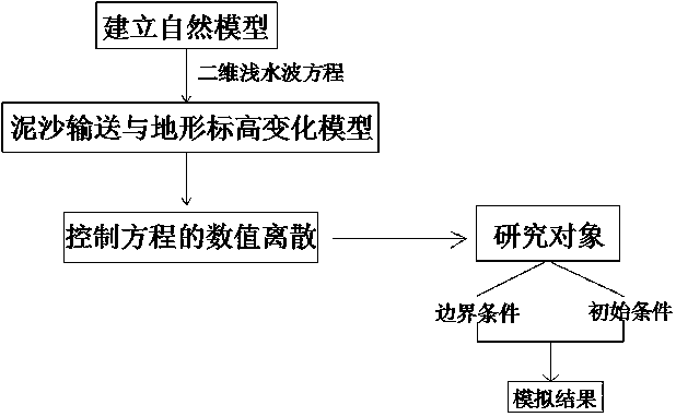
[0031] refer to Figure 1-2 , a method for constructing a coupling model of soil and water loss in subtropical regions, comprising the following steps:

[0032] S1: The erosion problem in soil and water conservation research is affected by the flow pattern, flow velocity, average water depth, resistance, and slope of the slope. For the soil and water loss project in the subtropical region of the research object, each indicator needs to be studied separately. Find out the regularity of soil erosion and strengthen the response to soil erosion control;

[0033] S2: The slope confluence changes and is unstable along the course, which is a three-dimensional movement. How...


PUM


Abstract

The present invention discloses a method for constructing a soil erosion coupling model in a subtropical region. The method comprises the following steps that: the erosion problem in the soil and water conservation research is affected by the flow state, the flow velocity, the average water depth, the resistance magnitude, the slope and the like of the slope surface; for the research object of thesoil erosion project in the subtropical region, a separate study needs to be conducted on each indicator to find out the regularity of soil erosion and to strengthen the reflection of soil erosion control; and the slope surface convergence varies along, is unstable, and belongs to three-dimensional movement, but the slope surface flow has typical shallow water wave characteristics such as a widerange, shallow water and the like. According to the method disclosed by the present invention, a numerical simulation model is established by organically coupling a two-dimensional shallow water waveequation, an unbalanced two-dimensional sediment transport equation and a ground elevation variation equation, the numerical model is verified by applying the numerical simulation model to the soil and water conservation experiments in the subtropical region, the law of soil erosion is obtained through practical results, and the variation law and spatial distribution characteristics of the water depth of the slope surface can be accurately simulated.

Description

technical field [0001] The invention relates to the technical field of water and soil loss, in particular to a method for constructing a coupling model of water and soil loss in subtropical regions. Background technique [0002] Soil erosion (also known as erosion or soil erosion) is a phenomenon in nature, which means that the surface of the earth is constantly worn by external forces such as wind, water, and ice melting, and the surface soil, parent material, and rocks are subjected to various damages and damages. The phenomenon of movement, accumulation and loss of water itself, including soil erosion and water loss, in a narrow sense, "soil erosion" refers to the phenomenon of water erosion of surface soil, which causes damage and loss of water and soil resources and land productivity, affecting human and For the survival of other animals and plants, the subtropical zone is a climate zone on the earth. Generally, the subtropical zone is located in the temperate zone clos...

Claims


Application Information

Patent Timeline
IPC IPC(8): G06F17/50
CPCG06F30/20
Inventor 黄光庆袁少雄张豫蔡德所尹小玲赵玲玲熊海仙
Owner GUANGZHOU INST OF GEOGRAPHY GUANGDONG ACAD OF SCI
Learn More