
Accurate Calculation Method of Distance and Required Time Based on Passive Pushbroom Imaging Mode

A technology of imaging mode and calculation method, which is applied in the field of remote sensing satellite imaging, and can solve the problems of reduced satellite earth observation efficiency, large error, and incomplete coverage of satellite observation target areas.

Active Publication Date: 2020-09-18
BEIJING INST OF SPACECRAFT SYST ENG
View PDF3 Cites 0 Cited by
  • Summary
  • Abstract
  • Description
  • Claims
  • Application Information

AI Technical Summary

Problems solved by technology

[0003] At present, the arrangement of remote sensing satellite imaging planning time in my country is still a technical difficulty. For example, in the traditional passive push-broom imaging mode, the method of calculating the time required for passive push-broom strips of a certain length still has large errors, and the time calculation is not accurate enough. There will be incomplete coverage of satellite observation target areas, too much useless information outside the required observation area, serious waste of effective observation time, and greatly reduced satellite earth observation efficiency

Method used


Image

  • Accurate Calculation Method of Distance and Required Time Based on Passive Pushbroom Imaging Mode
  • Accurate Calculation Method of Distance and Required Time Based on Passive Pushbroom Imaging Mode
  • Accurate Calculation Method of Distance and Required Time Based on Passive Pushbroom Imaging Mode

Examples


Embodiment Construction

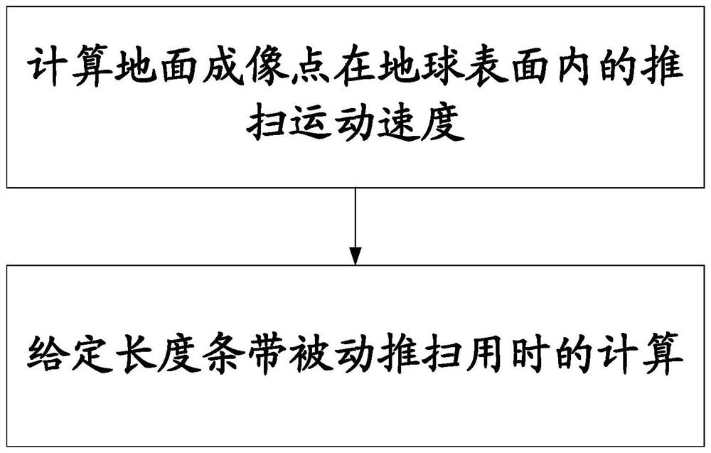
[0085] Below in conjunction with accompanying drawing and specific embodiment the present invention is described in further detail:

[0086] The technical problem solved by the invention is: in order to meet the requirement of accurate observation of the along-track strip under the passive push-broom imaging mode of the remote sensing satellite, the problem of accurate calculation of the push-broom distance and the required time is solved.

[0087] The technical solution adopted in the present invention is: an accurate calculation method based on the distance and the required time in the passive push-broom imaging mode, the steps are as follows:

[0088] 1. Calculate the velocity of the ground imaging point in the local horizontal plane in the ground-fixed system;

[0089] 2. Using the Newton iteration method to numerically solve the nonlinear equation of push-broom time.

[0090] Such as figure 1 Shown is the time calculation flow chart. It can be seen from the figure that ...


PUM


Abstract

The invention discloses a precise calculation method of distance and required time under a passive push-broom-based imaging mode, relates to the field of remote-sensing satellite imaging, and aims toimprove satellite earth-observation efficiency, and rationally and effectively arrange satellite earth-observation missions. How to precisely calculate the working time required for a passive push-broom on a certain-length strip is extremely important in satellite mission planning. For the technical difficulty point, the invention provides the precise calculation method of calculating the time required for passive push-broom planning of a satellite on the certain-length strip. Firstly, velocity of a ground imaging point in a local horizontal plane in an earth-fixed system is calculated, and then a Newton iteration method is utilized to carry out numerical-value solving on a non-linear equation of the push-broom time. The method is already applied to certain remote-sensing satellite earth-imaging simulation planning software under research, provides a technical guarantee for calculation of passive strip push-broom time and improvement of satellite working efficiency, and is significantin effects.

Description

technical field [0001] The invention relates to the field of remote sensing satellite imaging, in particular to an accurate calculation method based on distance and required time in passive push-broom imaging mode. Background technique [0002] For traditional optical remote sensing satellites, the options for completing specific observation activities are very limited, that is, the satellite can only swing sideways in the rolling direction to complete passive push-broom imaging of targets along the track. With the development of technology, agile optical imaging satellites represented by IKONOS, QuickBird, WorldView-1 / 2, GeoEye-1, and Pleiades-1 / 2 have appeared in optical remote sensing satellites. This type of satellite first expands the imaging working mode. In addition to the conventional passive push-broom imaging, an active push-broom imaging method is added (that is, the satellite roll angle / pitch angle maneuvers along a specific planning curve during the imaging proc...

Claims


Application Information

Patent Timeline
IPC IPC(8): G06F17/11G06F17/16
CPCG06F17/11G06F17/16
Inventor 刘云鹤刘凤晶于龙江朱玛原劲鹏王丽俐李响李果杨国巍王成伦
Owner BEIJING INST OF SPACECRAFT SYST ENG
Learn More