
Unmanned aerial vehicle formation monitoring and commanding system based on RNSS/RDSS system

A command system and unmanned aerial vehicle technology, applied in control/adjustment system, three-dimensional position/course control, vehicle position/route/altitude control, etc. Man-machine miniaturization design and other issues

Inactive Publication Date: 2018-02-09
重庆九洲星熠导航设备有限公司
View PDF5 Cites 5 Cited by
  • Summary
  • Abstract
  • Description
  • Claims
  • Application Information

AI Technical Summary

Problems solved by technology

[0005] The high-altitude link needs to use satellite links to implement stable communication interconnection, realize the command and control of the drone group, and information monitoring and collection by the ground station. The communication link needs to have encryption and decryption, cluster command functions, etc.; use Beidou RDSS short message service to realize For the above functions, this service is subject to business frequency restrictions and a single command relationship, etc., and cannot realize flexible and dynamic group command, continuous command, and simultaneous reception of information from all UAV user groups; UAV user groups implement on-the-spot operations, During emergency rescue and other missions, when encountering problems such as climate, temperature, remote areas, and signal blind spots, a single RNSS service cannot satisfy stable and continuous positioning and report location information; UAV architecture is complex, frequency points are diverse, and highly integrated It is easy to be interfered, and it is difficult to realize the miniaturization design of drones

Method used


Image

  • Unmanned aerial vehicle formation monitoring and commanding system based on RNSS/RDSS system
  • Unmanned aerial vehicle formation monitoring and commanding system based on RNSS/RDSS system
  • Unmanned aerial vehicle formation monitoring and commanding system based on RNSS/RDSS system

Examples


Embodiment Construction

[0025] The present invention will be further described below in conjunction with accompanying drawing:

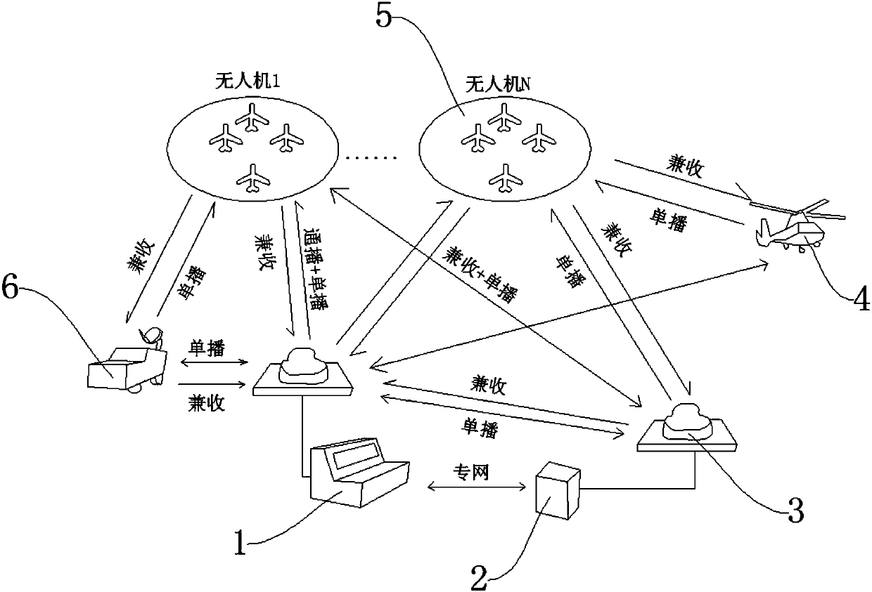
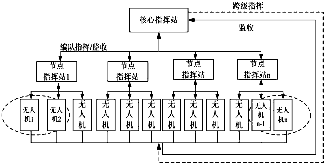
[0026] Such as Figure 1-Figure 5 As shown, the UAV formation monitoring and command system based on the RNSS / RDSS system includes the command center 1, the vehicle-mounted command node 6, and the airborne command node 4. The command center 1 is set on the ground and moves The vehicle-mounted command node 6 is arranged on the radar car, the airborne command node 4 is arranged on the air plane, and the command center 1 is connected with 1-N node command stations 3, and the node command station 3 There are 1-N drones 5 connected.

[0027] In the above-described embodiment, the command center 1 is a general node / core command station, and the command plane of the command center 1 can also receive all the unmanned aerial vehicles 5 and the vehicle-mounted command node 6, the airborne command node 4. The positioning and communication information of the backup command node 2 . ...


PUM


Abstract

The invention discloses an unmanned aerial vehicle formation monitoring and commanding system based on an RNSS / RDSS system, which comprises a commanding center, a vehicle-mounted commanding node and an airborne commanding node, wherein the commanding center is arranged on the ground; the vehicle-mounted commanding node is arranged on a moving radar vehicle; the airborne commanding node is arrangedon an airplane; the commanding center is connected with 1-N node commanding stations; and each node commanding station is connected with 1-N unmanned aerial vehicles. The unmanned aerial vehicle formation monitoring and commanding system based on the RNSS / RDSS system has the beneficial effects that defects of singleness of an unmanned aerial vehicle commanding system, unable dynamic grouping commanding, multi-frequency point miniaturization and easy interference and dual-mode position report continuity are overcome, the unmanned aerial vehicle can timely send the position report at what timeand under what circumstances and in what state, effective command from the ground station is received, quick formation is realized, and effective emergency rescue and other work can be carried out effectively.

Description

technical field [0001] The invention relates to the field of unmanned aerial vehicle command, in particular to an unmanned aerial vehicle formation monitoring and command system based on the RNSS / RDSS system. Background technique [0002] With the development of unmanned aerial vehicles at home and abroad, the unmanned aerial vehicle system has already developed from a single task detection to a multi-functional, multi-task, multi-system complex architecture, from micro-monitoring unmanned aerial vehicles to ton-level combat drones. Human and machine are all available. UAVs have relatively complete airborne navigation and communication electronic equipment, which can meet the requirements of fast, flexible and accurate services. The Beidou satellite navigation system has both RNSS and RDSS services, which can provide high-precision space-time information and highly reliable command and monitoring functions for UAVs. [0003] The biggest advantage of my country's Beidou sat...

Claims


Application Information

Patent Timeline
Patent Type & Authority Applications(China)
IPC IPC(8): G05D1/10
CPCG05D1/104
Inventor 樊闯曾蜜艺吕萌萌
Owner 重庆九洲星熠导航设备有限公司
Learn More