Method and system for accessing different spatial databases
A database and spatial technology, applied in the field of geographic information systems, can solve problems such as different interfaces, and achieve the effect of easy learning, low learning cost, and reduced development workload
- Summary
- Abstract
- Description
- Claims
- Application Information
AI Technical Summary
Problems solved by technology
Method used
Image


Examples
Embodiment 1
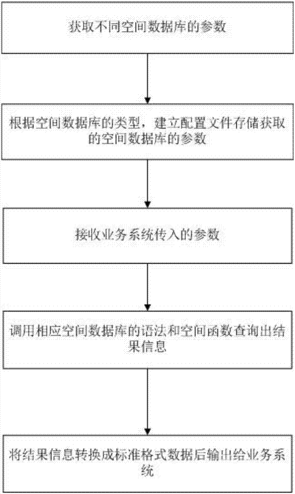
[0053] Embodiment 1: A method for accessing the PostGIS spatial database and performing spatial query is provided. The specific process is as follows:
[0054] 11) Understand the syntax and spatial functions of the PostGIS spatial database; among them, the primary key number of the layer stored in the PostGIS spatial database is gid, and the spatial field is geom;
[0055] 12) Obtain the IP address, port number, instance name, user name, and password of the PostGIS spatial database and save them in the configuration file corresponding to the PostGIS spatial database established in the data layer;
[0056] 13) Obtain the geographic coordinate system or projected coordinate system of the spatial data of the PostGIS spatial database, and save it to the configuration file corresponding to the PostGIS spatial database established in the data layer;
[0057] 14) According to the type of spatial database, read the configuration file corresponding to the parameters of the PostGIS spatial datab...
Embodiment 2
[0075] Embodiment 2: A method for accessing the SpatiaLite spatial database and performing surrounding queries is provided. The specific process is as follows:
[0076] 21) Understand the syntax and spatial functions of the SpatiaLite spatial database; among them, the layer primary key number stored in the Spatialite spatial database is pk_uid, and the spatial field is geometry;
[0077] 22) Get the storage path of the SpatiaLate spatial database and save it in the configuration file;
[0078] 23) Obtain the geographic coordinate system or projected coordinate system of the spatial data of the SpatiaLate spatial database and save it to the configuration file;
[0079] 24) According to the spatial database type, read the configuration file corresponding to the SpatiaLate spatial database parameters, and connect to the SpatiaLate spatial database;
[0080] 25) When the business system calls the vector data service, input the database type, query type, layer name, query field, filter condi...
Embodiment 3
[0097] Embodiment 3: A method for accessing WFS service and performing attribute query is provided. The specific process is as follows:
[0098] 31) Understand the WFS service definition specification; the specific definition is WFS refers to a Web element service. Web element service (WFS) returns element-level GML codes and provides transaction operations such as addition, modification, and deletion of elements. Further development of Web map service; OGC Web feature service allows clients to obtain geospatial data encoded with Geographic Markup Language (GML) from multiple web feature services. This Far East defines five operations: GetCapabilites returns the performance description of the web feature service Document (described in XML); DescribeFeatureType returns an XML document describing the structure of any feature that can provide services; GetFeature provides services for a request to obtain a feature instance; Transaction provides services for transaction requests; Lock...
PUM
 Abstract
Description
Claims
Application Information
 - R&D
- Intellectual Property
- Life Sciences
- Materials
- Tech Scout
- Unparalleled Data Quality
- Higher Quality Content
- 60% Fewer Hallucinations
Browse by: Latest US Patents, China's latest patents, Technical Efficacy Thesaurus, Application Domain, Technology Topic, Popular Technical Reports.
© 2025 PatSnap. All rights reserved.Legal|Privacy policy|Modern Slavery Act Transparency Statement|Sitemap|About US| Contact US: help@patsnap.com