
System and method for UAV over-the-horizon control, image and/or data reception

An unmanned aerial vehicle, over-the-horizon technology, used in control/regulation systems, closed-circuit television systems, radio transmission systems, etc., to save flight control time and improve resource reuse efficiency

Active Publication Date: 2018-11-09
西安征途网络科技有限公司
View PDF7 Cites 0 Cited by
  • Summary
  • Abstract
  • Description
  • Claims
  • Application Information

AI Technical Summary

Problems solved by technology

[0003] In order to solve the technical problem that continuous and precise control of the UAV platform cannot be realized in a long-distance and / or complex environment, the present invention provides a system for realizing UAV over-the-horizon control, image and / or data reception and method

Method used


Image

  • System and method for UAV over-the-horizon control, image and/or data reception
  • System and method for UAV over-the-horizon control, image and/or data reception

Examples


Embodiment Construction

[0043] The present invention will be further described below in conjunction with the accompanying drawings and specific embodiments.

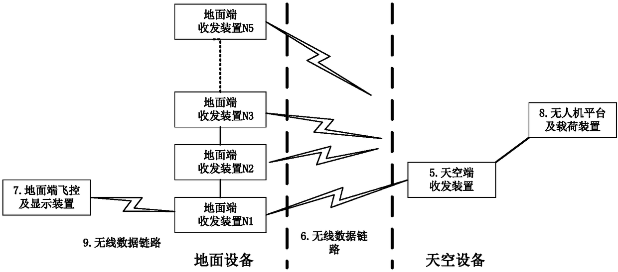
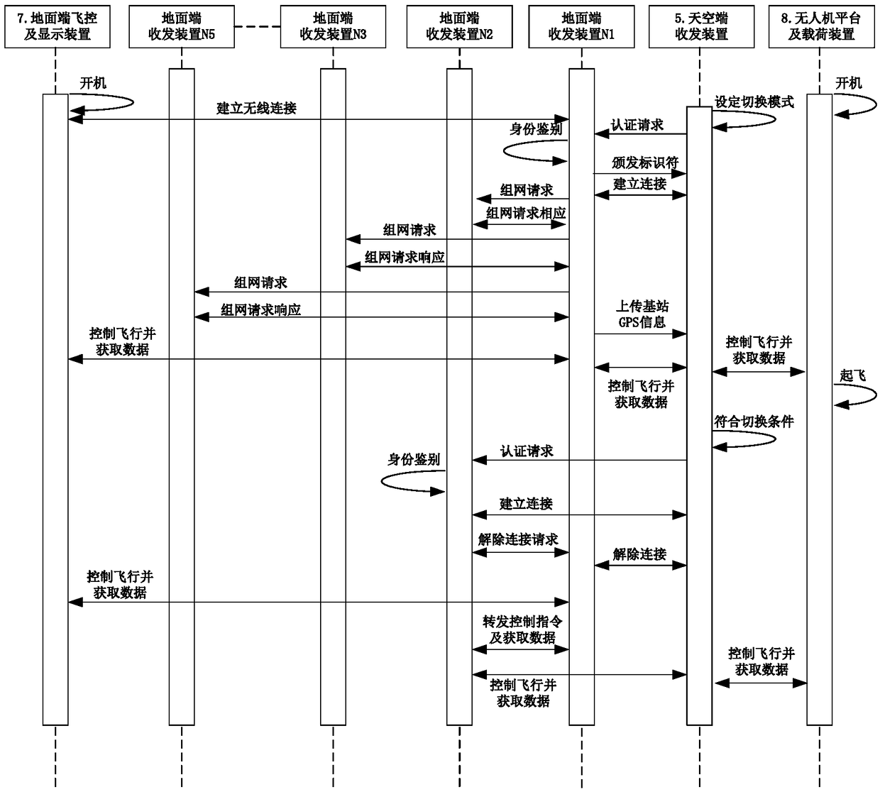
[0044] see figure 1 The system provided by the present invention to realize UAV over-the-horizon control and image and / or data reception includes five ground terminals arranged between the ground terminal flight control and display device 7 and the UAV platform and load device 8 Transceivers N1-N5 and an air transceiver 5.

[0045] The deployment positions of the five ground-side transceivers are determined according to environmental conditions. In areas such as highways and railways, they are usually deployed in a linear manner along the road thread, and in complex areas such as cities, they are usually deployed in a network. The effective coverage in a specific environment shall prevail, and the coverage of adjacent ground-side transceivers can only have partial signal overlap in their respective edge areas to ensure control accuracy.

[0046...


PUM


Abstract

The invention provides a system and a method of realizing trans-horizon control, image and / or data receiving of a UAV, aiming to solve the problem that a UAV platform cannot be controlled constantly and accurately in a long distance and / or complex environment. The system comprises N ground transceiver devices and M air transceiver devices that are respectively arranged between a ground fly control and display device and the UAV platform and between the ground fly control and display device and a load device, wherein N is greater than or equal to 3 and M is greater than or equal to 1; the N ground transceiver devices form a communicated network through a communication protocol, wherein a ground transceiver device Ni closest to the ground fly control and display device is connected with the ground fly control and display device through a wireless data link; and the ground transceiver device Ni is used for receiving and forwarding GPS range information to a corresponding air transceiver device. Through adoption of the method and system, the UAV can be controlled constantly and accurately in a trans-horizon distance and / or complex environment, and can return the data.

Description

technical field [0001] The invention relates to a system and a method for realizing control of unmanned aerial vehicles beyond visual range and image and / or data reception. In the present invention, the over-the-horizon refers to: 1. The distance is at least 5 kilometers, which is beyond the visual range of people; Background technique [0002] With the increasing improvement of UAV platform technology, UAVs are more and more popular in various fields due to their advantages of flexibility, efficiency, convenience, and intelligence. Professional-level UAVs are widely used in the actual work field. It is becoming more and more obvious, such as highway / railway / bridge detection, oil pipeline detection, power line detection, urban traffic and safety monitoring and other fields. With the continuous expansion of the application field of professional drones, its application environment is becoming more and more complex. Taking the highway detection field as an example, it has a co...

Claims


Application Information

Patent Timeline
Patent Type & Authority Patents(China)
IPC IPC(8): H04B1/40H04B7/155H04N7/18H04W4/02H04W12/06G05D1/10
CPCG05D1/101H04B1/40H04B7/155H04B7/15507H04N7/18H04W4/021H04W4/025H04W12/06
Inventor 郭宏万晓辉
Owner 西安征途网络科技有限公司
Learn More