System and method for ship water gauge measurement based on UAV
A technology of measurement system and measurement method, which is applied in the field of intelligent measurement system for port shipping and weight calculation system, and ship load calculation system, which can solve the problems of damaged shooting lens, etc., and achieve the effect of improving efficiency, realizing automation and intelligence
- Summary
- Abstract
- Description
- Claims
- Application Information
AI Technical Summary
Problems solved by technology
Method used
Image
Examples
Embodiment 1
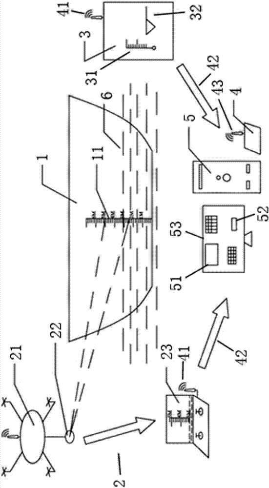
[0027] Such as figure 1 As shown, the product of this embodiment is a ship water gauge measurement system based on unmanned aerial vehicles, including a ship 1 with a water gauge scale 11, and also includes:
[0028] The UAV water gauge video acquisition device 2 is configured to track changes in the position of the waterline area;
[0029] The terminal collection device 3 (i.e. a handheld data collection terminal) is configured to collect the density of seawater and the liquid level of the water and oil tank;
[0030] The data receiving device 4 is configured to receive the data transmitted from the above two devices;
[0031] The data processing server 5 is configured to process the data transmitted from the data receiving device 4, and combine the data to calculate the ship's load capacity.
[0032] The drone water gauge video acquisition device 2 of the present embodiment includes a drone 21, a camera 22 and a remote control system 23. The drone 21 can fly stably over th...
Embodiment 2
[0037] A water gauge measurement method based on the above-mentioned embodiment system, the UAV water gauge video acquisition device 2 is used to track the change of the position of the waterline area; the terminal acquisition device 3 is used to collect seawater density and the liquid level height of the water and oil tank ; The data receiving device 4 is used to receive the data transmitted from the above two devices; the data processing server 5 is used to process the data transmitted from the data receiving device 4, and calculate the load capacity of the ship in combination with the data.
[0038] After the ship 1 docks at the port, the water gauge inspection personnel manipulate the UAV 21 carrying the camera (i.e. the camera 22) into the docking area of the ship 1, and the images collected by the UAV 21 equipped with the camera are sent back to the control platform of the UAV 21 in real time. On the screen, the water gauge acceptance personnel adjusts the hovering posi...
PUM
 Abstract
Description
Claims
Application Information
 - Generate Ideas
- Intellectual Property
- Life Sciences
- Materials
- Tech Scout
- Unparalleled Data Quality
- Higher Quality Content
- 60% Fewer Hallucinations
Browse by: Latest US Patents, China's latest patents, Technical Efficacy Thesaurus, Application Domain, Technology Topic, Popular Technical Reports.
© 2025 PatSnap. All rights reserved.Legal|Privacy policy|Modern Slavery Act Transparency Statement|Sitemap|About US| Contact US: help@patsnap.com

