A secure outsourcing search method for multitemporal hyperspectral remote sensing images
A technology of hyperspectral remote sensing and remote sensing images, which is applied in the field of secure outsourced search of multi-temporal hyperspectral remote sensing images, which can solve the problems of large amount of calculation and inability to solve the encryption and decryption of multi-band images, so as to improve accuracy, speed and prevent The effect of image leaks
- Summary
- Abstract
- Description
- Claims
- Application Information
AI Technical Summary
Problems solved by technology
Method used
Image
Examples
Embodiment 1
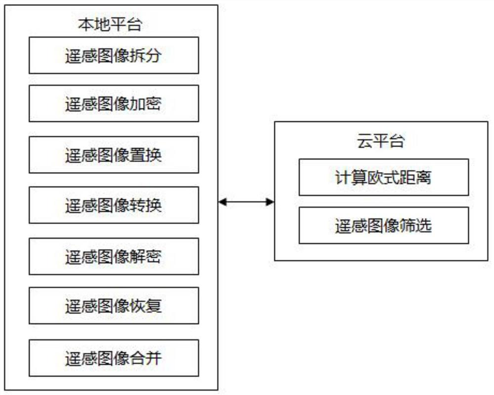
[0069] refer to figure 1 , figure 1 It is a schematic diagram of the overall structure of the present invention. A secure outsourcing search method for multi-temporal hyperspectral remote sensing images of the present invention includes a local platform and a cloud platform, and the local platform includes a remote sensing image splitting module, a remote sensing image encryption module, a remote sensing image replacement module, a remote sensing image conversion module, and a remote sensing image A decryption module, a remote sensing image restoration module, and a remote sensing image merging module, the cloud platform includes a module for calculating Euclidean distance and a remote sensing image screening module.
[0070] refer to figure 2 , figure 2 It is a schematic diagram of the general workflow of the present invention, and the flow process of the safe outsourcing search method of the multi-temporal hyperspectral remote sensing image is as follows:
[0071] S01:...
Embodiment 2
[0083] refer to image 3 , image 3 It is a schematic diagram of the specific work flow of the present invention, and the specific work flow of a secure outsourced search method for multi-temporal hyperspectral remote sensing images of the present invention is as follows.
[0084] S01: Upload remote sensing images to cloud platform storage
[0085] Upload all remote sensing images to the cloud platform for storage, and perform steps S02-S05 on all remote sensing images and index remote sensing images.
[0086] S02: Split remote sensing images on the local platform
[0087] Let the length of the remote sensing image be height, the width be width, and the number of bands of the remote sensing image be pic_bandNum, split the remote sensing image into pic_bandNum band images, and read the 16-bit deep gray value of each band image.
[0088] S03: Encrypt remote sensing images on the local platform
[0089] refer to Figure 4 , Figure 4 It is the flow chart of remote sensing i...
Embodiment 3
[0119] A specific implementation manner of a secure outsourced search method for multi-temporal highlight remote sensing images of the present invention is as follows.
[0120] S01: Upload remote sensing images to cloud platform storage
[0121] Upload all remote sensing images to the cloud platform for storage, and perform steps S02-S05 on all remote sensing images and index remote sensing images.
[0122] S02: Split remote sensing images on the local platform
[0123] Suppose the length of the remote sensing image is 512, the width is 512, and the number of bands of the remote sensing image is 200. The remote sensing image is split into 200 band images, and the 16-bit gray value of each band image is read.
[0124] S03: Encrypt remote sensing images on the local platform
[0125] S031: Store the gray values of all pixels in the remote sensing image into an array, calculate the average value of all gray values, and subtract the average value from each gray value in the ar...
PUM
 Abstract
Description
Claims
Application Information
 - Generate Ideas
- Intellectual Property
- Life Sciences
- Materials
- Tech Scout
- Unparalleled Data Quality
- Higher Quality Content
- 60% Fewer Hallucinations
Browse by: Latest US Patents, China's latest patents, Technical Efficacy Thesaurus, Application Domain, Technology Topic, Popular Technical Reports.
© 2025 PatSnap. All rights reserved.Legal|Privacy policy|Modern Slavery Act Transparency Statement|Sitemap|About US| Contact US: help@patsnap.com


