
Intercity road traffic congestion degree ranking method and system

A technology of congestion level and road traffic, applied in traffic control system of road vehicles, traffic control system, traffic flow detection, etc. Avoid bias, fair and reasonable ranking effect

Inactive Publication Date: 2017-09-05
北京博研智通科技有限公司
View PDF11 Cites 6 Cited by
  • Summary
  • Abstract
  • Description
  • Claims
  • Application Information

AI Technical Summary

Problems solved by technology

[0004] At present, relevant companies in China rank and release the degree of urban congestion, which leads to disputes about the basis of the ranking in relevant cities. There are three main problems: first, the method is to select the traffic condition data of some roads in a city, Represents the data of the entire road network of the city, that is, the sampling mode is used to estimate the congestion status of all the roads in a city, so it cannot fully reflect the overall traffic congestion status of a city; the second is to obtain the data of the average speed of the road when the road is clear and the average speed of the current road. Comparing the data of vehicle speed, calculating the ratio and processing according to the ratio, it becomes the congestion index of a city. Use this index as the basis to compare and sort with other cities. The one with the largest congestion index is the first. This calculation method is one-sided; The third is that cities across the country are different in size and road network density, so directly using this data to sort is not comparable

Method used


Image

  • Intercity road traffic congestion degree ranking method and system
  • Intercity road traffic congestion degree ranking method and system
  • Intercity road traffic congestion degree ranking method and system

Examples


Embodiment 1

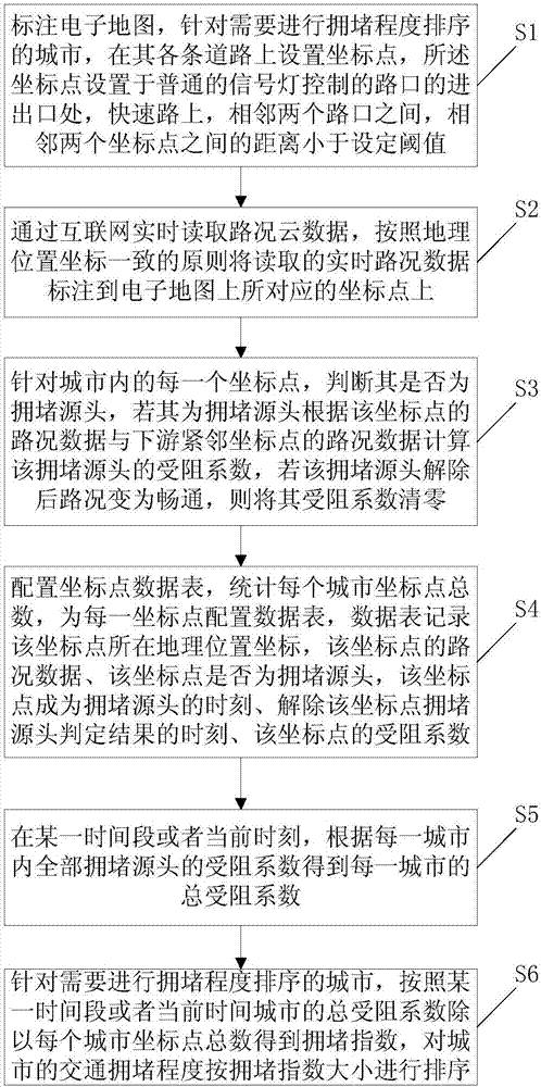
[0056] This embodiment provides a method for sorting the degree of road traffic congestion between cities, which is applied in the control center system of the traffic management department, including the following steps:

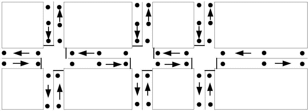
[0057] S1: Mark the electronic map, and set coordinate points on each road of the city that needs to be sorted by congestion level. The coordinate points are set at the entrance and exit of the intersection controlled by ordinary signal lights, and two adjacent intersections on the expressway Between, the distance between two adjacent coordinate points is less than the set threshold; such as figure 2 As shown in , a schematic diagram of an electronic map in a small area of ​​a certain city is intercepted, which is a standard electronic map. Mark the coordinate points on the electronic map, and the actual distance between two adjacent coordinate points can be set between 100 meters and 150 meters. The coordinate points can be set at any position, preferabl...

Embodiment 2

[0089] This embodiment provides a system for ranking the degree of road traffic congestion between cities, such as Figure 5 shown, including:

[0090] The coordinate point labeling module 1 is used to mark the electronic map. For cities that need to be sorted by congestion level, coordinate points are set on each road. The coordinate points are set at the entrance and exit of the intersection controlled by ordinary signal lights. , between two adjacent intersections, the distance between two adjacent coordinate points is less than the set threshold; for example figure 2 As shown in , a schematic diagram of an electronic map in a small area of ​​a certain city is intercepted, which is a standard electronic map. Mark the coordinate points on the electronic map, and the actual distance between two adjacent coordinate points can be set between 100 meters and 150 meters. The coordinate points can be set at any position, preferably at the entrance and exit of intersections contr...


PUM


Abstract

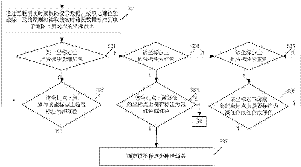
The invention provides an intercity road traffic congestion degree ranking method and system. According to the invention, in allusion to cities requiring congestion degree ranking, coordinate points are set on each road of the cities, the distance between two adjacent coordinate points is less than a set threshold, road condition cloud data is read in real time through the Internet, and the read real-time road condition data is marked on the corresponding coordinate points; in allusion to each coordinate point in the cities, if the coordinate point is a congestion source, the blocking coefficient is calculated according to the road condition data of the coordinate point and the road condition data of a downstream adjacent coordinate point, a congestion index of the city is acquired by dividing the total blocking coefficient of the city in a certain time period or at the current moment by the total number of coordinate points of the city or jurisdiction, and the traffic congestion degrees of the cities are sorted according to the congestion indexes. Ranking performed on the traffic congestion degree of each city according to the congestion index reflects that the number of coordinate points set in a large city is great, the number of coordinate points set in a small city is small, a deviation caused by the difference in city scale can be avoided, and the ranking is enabled to be fairer and more reasonable.

Description

technical field [0001] The invention relates to the field of road traffic management, in particular to a method and a system for sorting the degree of road traffic congestion between cities. Background technique [0002] With the increasing demand for traffic, road traffic congestion continues to intensify, spreading from megacities to small and medium-sized cities, seriously affecting people's daily travel, and becoming a social problem that has attracted great attention from governments at all levels. Whether it is a city's decision-making department, management department, or travelers, they all want to quickly and accurately know the current road congestion level in their city. [0003] Large companies that have been able to obtain the road congestion status of major cities across the country on a large scale using Internet technology have invented various congestion index calculation methods. It also ranks the road congestion levels of major cities in China, which has ...

Claims


Application Information

Patent Timeline
IPC IPC(8): G08G1/01
CPCG08G1/0133
Inventor 姜廷顺石永辉李萌隽海民朱朝晖贾胜勇邱红桐潘汉中戴帅邹平王军利王家捷侯文宇尹胜超
Owner 北京博研智通科技有限公司
Learn More