


Quick Research
Generate reliable direction feasibility study reports for your R&D in just a few steps.

Technical Q&A
Discover and master advanced knowledge NOW. Basics, ideas, possibilities, all at once.

Find Solutions
As an expert in R&D theories, this can generate solutions to your technical problems instantly.

Evaluate Feasibility
Analyze your overall solution with one click, know your potential R&D risks in advance.

Monitor Landscape
Get weekly tech updates, stay abreast of the latest tech innovations and key insights.
An accelerated coordinate conversion method and device based on a recorder management platform
A technology of coordinate conversion and management platform, applied in geographic information database, special data processing application, multimedia data retrieval and other directions, can solve the problem that the recorder management platform does not have offset value cache, which affects the operation performance of the platform, and achieves high speed. , reduce service costs and improve performance
- Summary
- Abstract
- Description
- Claims
- Application Information
AI Technical Summary
Problems solved by technology
Method used
Image

Examples
specific Embodiment approach 1
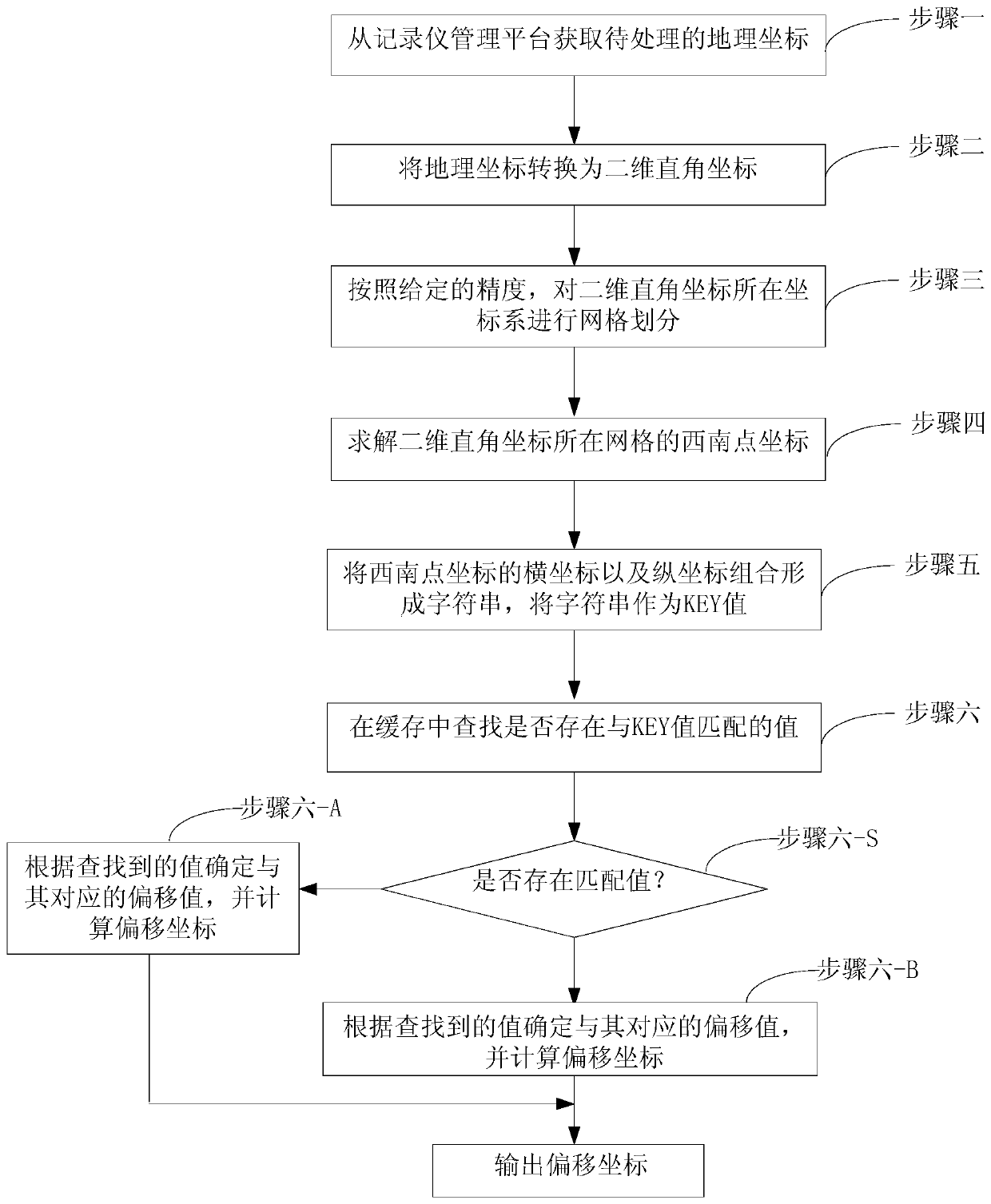
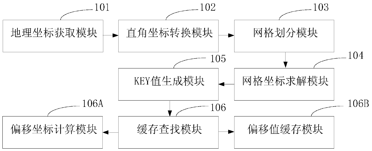
[0024] Specific implementation mode one: the accelerated coordinate conversion method based on the recorder management platform of this embodiment is as follows: figure 1 shown, including:
[0025] Step 1: Obtain the geographic coordinates to be processed.
[0026] Step 2: Transform the geographic coordinates into two-dimensional Cartesian coordinates. The units of geographic coordinates are degrees, and the units of two-dimensional Cartesian coordinates are centimeters.
[0027] For example, take the point where the meridian passes the equator as the origin, the longitude as the abscissa, the latitude as the ordinate, and the east longitude and north latitude as positive, establish a coordinate system, then the calculation of the two-dimensional Cartesian coordinates of each point in the east longitude and north latitude area on the earth surface The method is as follows, the unit is meter.
[0028] Abscissa: x=R*(lng*cos(lat*PI / 180)*PI / 180)
[0029] Ordinate: y=R*(lat*PI...
specific Embodiment approach 2
[0040] Embodiment 2: This embodiment differs from Embodiment 1 in that in step 6, when there is a value that matches the KEY value, it specifically includes the following steps:
[0041] Step A1: Get the KEY value.
[0042] Step A2: Obtain the offset corresponding to the KEY value.
[0043] Step A3: Calculate the Cartesian coordinates of the coordinates corresponding to the KEY value. The Cartesian coordinates here are the horizontal and vertical coordinates that split the string of the KEY value into, which represent the coordinates of the grid.
[0044] Step A4: Transform the Cartesian coordinates into geographic coordinates as offset coordinates.
[0045] Other steps and parameters are the same as those in Embodiment 1.
specific Embodiment approach 3
[0046] Specific embodiment three: the difference between this embodiment and specific embodiment one or two is:
[0047] In step six, when there is no value matching the KEY value, specifically include the following steps:
[0048] Step B1: Obtain the offset coordinates of the coordinates corresponding to the KEY value through the network;
[0049] Step B2: Convert the coordinates and offset coordinates corresponding to the KEY value into two-dimensional Cartesian coordinates;
[0050] Step B3: Subtract the two-dimensional rectangular abscissa of the offset coordinate from the two-dimensional rectangular abscissa of the corresponding coordinate of KEY and round it up as the abscissa of the offset; subtract the two-dimensional rectangular ordinate of the offset coordinate from the corresponding KEY The two-dimensional Cartesian ordinate of the coordinate is rounded up and used as the ordinate of the offset.
[0051] Other steps and parameters are the same as those in Embodime...
PUM
 Abstract
Description
Claims
Application Information
 - R&D Engineer
- R&D Manager
- IP Professional
- Industry Leading Data Capabilities
- Powerful AI technology
- Patent DNA Extraction
Browse by: Latest US Patents, China's latest patents, Technical Efficacy Thesaurus, Application Domain, Technology Topic, Popular Technical Reports.
© 2024 PatSnap. All rights reserved.Legal|Privacy policy|Modern Slavery Act Transparency Statement|Sitemap|About US| Contact US: help@patsnap.com