Method and device for assessing the availability of satellite navigation system

A satellite navigation system and the technology of the navigation system, which are applied to the satellite radio beacon positioning system, measurement device, radio wave measurement system and other directions, can solve the problems of incompleteness and inaccurate availability of the satellite navigation system, and achieve the effect of improving the accuracy

Active Publication Date: 2017-07-11
BEIHANG UNIV
View PDF11 Cites 8 Cited by
  • Summary
  • Abstract
  • Description
  • Claims
  • Application Information

AI Technical Summary

Problems solved by technology

Therefore, this method of assessing the usability of satellite navigation systems is inaccurate and incomplete

Method used


Image

  • Method and device for assessing the availability of satellite navigation system
  • Method and device for assessing the availability of satellite navigation system
  • Method and device for assessing the availability of satellite navigation system

Examples


Embodiment Construction

[0051] In order to make the purpose, technical solutions and advantages of the embodiments of the present invention clearer, the technical solutions in the embodiments of the present invention will be clearly and completely described below in conjunction with the drawings in the embodiments of the present invention. Obviously, the described embodiments It is a part of embodiments of the present invention, but not all embodiments. Based on the embodiments of the present invention, all other embodiments obtained by persons of ordinary skill in the art without creative efforts shall fall within the protection scope of the present invention.

[0052] The Global Navigation Satellite System (GNSS) is a space-based radio-navigation positioning system that provides position, velocity and time information to users. As an important infrastructure for the construction of the national information system, it has a major impact on various fields such as national security, national economic de...


PUM


Abstract

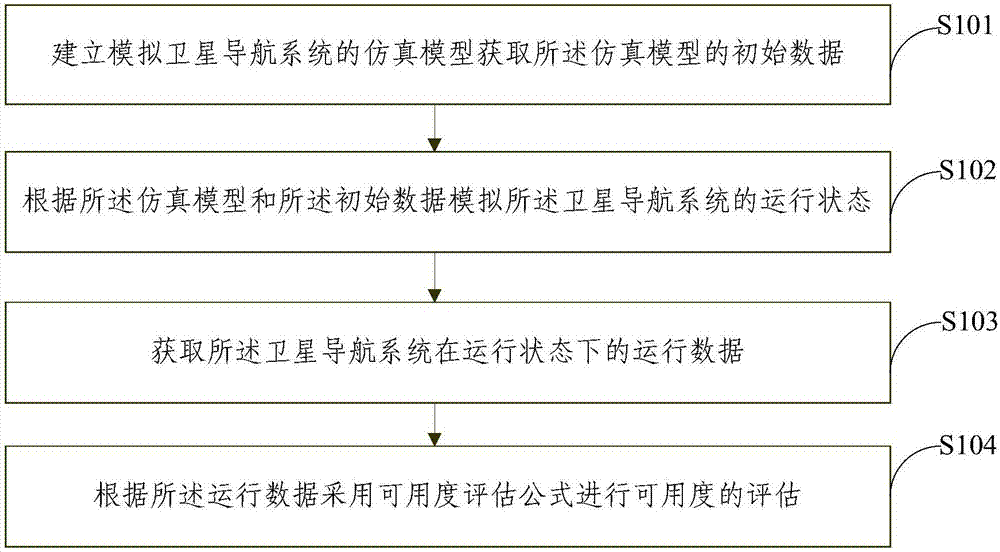
The invention provides a method and a device for assessing the availability of a satellite navigation system. The method comprises: creating a simulation model for a simulated satellite navigation system; obtaining the initial data of the simulation model; according to the simulation model and the initial data, simulating the running state of the satellite navigation system; obtaining the running data of the satellite navigation system in the running state; and according to the running data, using an availability evaluation formula to perform the assessment of the availability. According to the technical schemes of the invention, the running data of a satellite navigation system in the running state are utilized to predict the availability of the satellite navigation system constellation in real time, which increases the precision of availability of the satellite navigation system and the real time assessment of the availability. Simple and convenient, the device can be applied widely in engineering.

Description

technical field [0001] The invention relates to the technical field of satellite navigation, in particular to a method and device for evaluating the availability of a satellite navigation system. Background technique [0002] The Global Navigation Satellite System (GNSS) is a space-based radio-navigation positioning system that provides position, velocity and time information to users. As an important infrastructure for the construction of the national information system, it has a major impact on various fields such as national security, national economic development, and national defense modernization. In recent years, navigation technology and its application have developed rapidly, and have become a pillar industry in the field of information technology. Satellite technology has greatly promoted the information revolution, and has excellent performance in military reconnaissance, communication and broadcasting, remote sensing, navigation, positioning, timing, earth resou...

Claims


Application Information

Patent Timeline
Patent Type & Authority Applications(China)
IPC IPC(8): G01S19/20
CPCG01S19/20
Inventor 赵广燕关孝蒙孙宇锋胡薇薇李丹
Owner BEIHANG UNIV
Why Eureka
Try Eureka