3Dflyover modeling method based on Reeb graphs

A technology for 3D modeling and overpasses, applied in 3D modeling, image data processing, instruments, etc., can solve the problems of incomplete model establishment, inability to accurately describe the structural details and differences of overpasses, etc.

Active Publication Date: 2017-07-04
HEFEI UNIV OF TECH
View PDF2 Cites 9 Cited by
  • Summary
  • Abstract
  • Description
  • Claims
  • Application Information

AI Technical Summary

Problems solved by technology

However, the current electronic map is not perfect for the establishment of complex road sections such as overpasses in reality, and the complete road information of these complex road sections such as overpasses cannot be reflected in the electronic map.
[0003] The model of the overpass in the current electronic map is generally represented by a plane model. This form of representation will send the location information to the driver on the navigation map, so that the driver cannot clearly judge where the vehicle is located in the shielding structure of the overpass.
In addition, in many 3D modeling methods of overpasses, the entire overpass is fitted. This method easily makes the structure of the overpass model very different from the actual overpass, and cannot accurately describe the structural details of the overpass.

Method used


Image

  • 3Dflyover modeling method based on Reeb graphs
  • 3Dflyover modeling method based on Reeb graphs
  • 3Dflyover modeling method based on Reeb graphs

Examples


Embodiment Construction

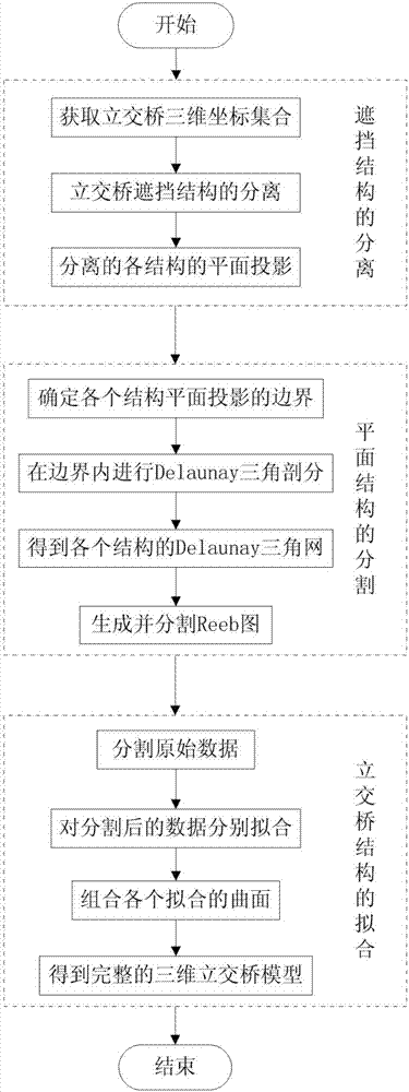
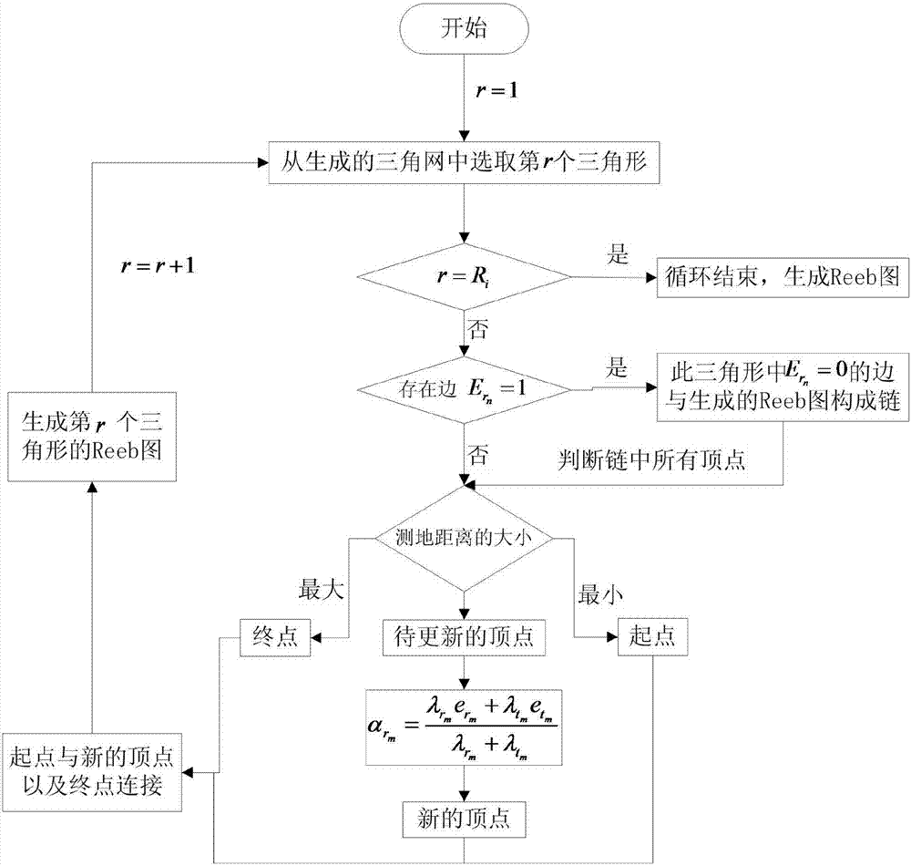
[0057] In this example, if figure 1 As shown, a 3D modeling method for overpasses based on Reeb diagrams is applied to any 3D discrete coordinates of overpasses, and is carried out as follows:

[0058] Step 1. Extraction of overpass deck data:

[0059] Through the airborne LIDAR space measurement system, the three-dimensional coordinate point set of the overpass bridge deck is obtained, which is denoted as W={w 1 ,w 2 ,...,w n ,...,w N},w n Indicates the nth three-dimensional coordinate point, and has w n (x n ,y n ,z n ); x n Indicates the x-axis coordinate of the nth three-dimensional coordinate point, y n Indicates the y-axis coordinate of the nth three-dimensional coordinate point, z n Indicates the z-axis coordinate of the nth three-dimensional coordinate point, n=1,2,...,N;

[0060] Before the overpass shielding structure is extracted, the content of the three-dimensional coordinate set of the overpass deck obtained by the airborne LIDAR space measurement sys...


PUM


Abstract

The invention discloses a 3Dflyover modeling method based on Reeb graphs. The method includes the following steps: 1. acquiring a discrete coordinate of the 3D image of any flyover; 2. extracting structures of the flyover that mutually cover each other and projecting the structures; 3. determining the boundaries of the scatter points of the projection; 4. carrying out Delaunay triangle division; 5. generating a Reeb graph on the basis of a triangular mesh; 6. determining key points of the Reeb graph, and dividing the Reeb graph; and 7. filling the Reeb graph and knitting the scatter points. According to the invention, the method can achieve 3D modeling of complex road sections of the flyover in an electronic map, such that information of all kinds of complex road sections efficiently represented in the electronic map, and a navigation system can be linked to the electronic map, road information of the current electronic map is further enriched and improved, and more accurate information is provided for the user.

Description

technical field [0001] The invention belongs to the field of three-dimensional modeling of overpasses, in particular to a method for three-dimensional modeling of overpasses based on Reeb diagrams. Background technique [0002] In recent years, with the improvement of people's living standards, the number of cars owned by families has gradually increased. During the driving process, people have higher and higher needs and requirements for navigation maps. The most basic thing for navigation maps is to display the position of the vehicle being driven in the map and the complete information of each road structure in the map. At present, general electronic maps have very complete modeling methods for relatively simple road forms such as highway networks. They can describe the real road information through simple plane modeling methods, and then use GPS navigation technology to Carry out positioning and tell the driver the location information of the vehicle. However, the curr...

Claims


Application Information

Patent Timeline
Patent Type & Authority Applications(China)
IPC IPC(8): G06T17/00
CPCG06T17/00
Inventor 丁建勋吴晓东周珏秦瑞科李棒钟业文唐飞陈一锴龙建成石琴
Owner HEFEI UNIV OF TECH
Why Eureka
Try Eureka