


Quick Research
Generate reliable direction feasibility study reports for your R&D in just a few steps.

Technical Q&A
Discover and master advanced knowledge NOW. Basics, ideas, possibilities, all at once.

Find Solutions
As an expert in R&D theories, this can generate solutions to your technical problems instantly.

Evaluate Feasibility
Analyze your overall solution with one click, know your potential R&D risks in advance.

Monitor Landscape
Get weekly tech updates, stay abreast of the latest tech innovations and key insights.
Laser radar point cloud data obstacle detection algorithm
A technology of lidar and point cloud data, which is applied in image data processing, calculation, and measurement devices, and can solve problems such as missing detection, missing 3D point clouds, and broken grids
- Summary
- Abstract
- Description
- Claims
- Application Information
AI Technical Summary
Problems solved by technology
Method used
Image

Examples
Embodiment Construction
[0039] The present invention will be further described in detail below in conjunction with the examples.
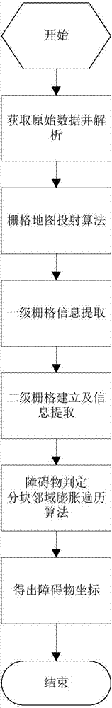
[0040] Obtain the original data of multi-dimensional lidar through real-time UDP data packets. Each data packet contains the distance information and angle information returned by each laser beam. We define the data output by the lidar for one revolution as one frame of data.
[0041] After analyzing the original data, each lidar point data contains three-dimensional space position coordinates (x, y, z), vertical angle verAngle, horizontal angle horAngle, intensity, and laser beam ID.
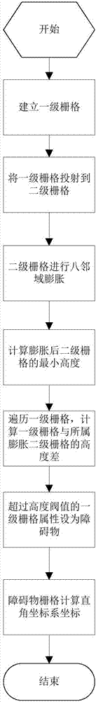
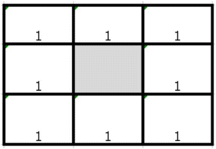
[0042] Create a first-level grid map grid[(M+1),(N+1)], the grid size is G. Project the 3D points in the Cartesian coordinate system onto the (M,N) grid plane. Each grid only saves the maximum height zmax and the minimum height zmin. Calculate the grid coordinates (i, j) (0≤i≤M; 0≤j≤N) data information of the three-dimensional point, so that the amount of data to be processed is reduce...
PUM
 Abstract
Description
Claims
Application Information
 - R&D Engineer
- R&D Manager
- IP Professional
- Industry Leading Data Capabilities
- Powerful AI technology
- Patent DNA Extraction
Browse by: Latest US Patents, China's latest patents, Technical Efficacy Thesaurus, Application Domain, Technology Topic, Popular Technical Reports.
© 2024 PatSnap. All rights reserved.Legal|Privacy policy|Modern Slavery Act Transparency Statement|Sitemap|About US| Contact US: help@patsnap.com