
Province-city-county three-level power grid programming GIS drawing system and method

A power grid planning and drawing method technology, applied in the direction of electrical digital data processing, geographic information database, structured data retrieval, etc., can solve the problems of unorganized data viewing, chaotic planning GIS data layering, and scattered data storage, etc., to achieve improved Work efficiency and work quality, improve the level of planning business, reduce the effect of manual drawing time

Inactive Publication Date: 2016-10-26
RES INST OF ECONOMICS & TECH STATE GRID SHANDONG ELECTRIC POWER +1
View PDF0 Cites 23 Cited by
  • Summary
  • Abstract
  • Description
  • Claims
  • Application Information

AI Technical Summary

Problems solved by technology

[0004] (1) The data production process is all stand-alone production, the production efficiency is low, and the data is scattered and stored, so the integrity, version control and security of the data cannot be effectively guaranteed
[0005] (2) State Grid requires the data to be submitted in CAD format. Most of the current planning data is generated by MAPGIS, which does not support conversion to CAD. Therefore, two copies of data need to be maintained, which doubles the workload.
[0006] (3) The layering of the existing planning GIS data is chaotic, and some different types of power equipment are all on the same layer, resulting in insufficient organization of data viewing
[0007] (4) The current data are all stored in MAPGIS or CAD, and cannot be displayed in the WEB system. It is extremely inconvenient to report and demonstrate the results of planning data production
[0008] (5) Grid graphics need to be drawn manually or copied from previously drawn CAD files, which seriously affects the efficiency of grid design work

Method used


Image

  • Province-city-county three-level power grid programming GIS drawing system and method
  • Province-city-county three-level power grid programming GIS drawing system and method
  • Province-city-county three-level power grid programming GIS drawing system and method

Examples


Embodiment Construction

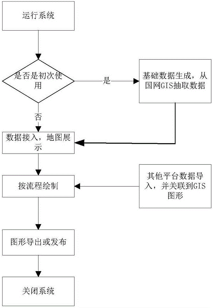
[0046] The present invention will be further described below in conjunction with the accompanying drawings and embodiments.

[0047] A three-level power grid planning GIS drawing system for provinces, prefectures and counties, such as figure 1 As shown, including the center service layer, base map service layer and business data layer;

[0048] The base map service layer provides base map services to better display the business data layer. The business data layer includes current data and planning data, which is the basis of GIS data. The central service layer is responsible for managing and rendering the business data layer, managing Including department management, user management, graphic configuration information (display scale, display layer, etc.), menu permissions, etc. Rendering refers to converting grid data information into equipment graphics elements understood by grid staff for display.

[0049] It is convenient for users to manage and use business data more intui...


PUM


Abstract

The invention discloses a province-city-county three-level power grid programming GIS drawing system and method. The system comprises a central service layer, a base map service layer and a business data layer. The central service layer establishes a data relation model according to an input power grid programming model and converts the data relation model into equipment pixel association information which is displayed on the base map service layer. The province-city-county three-level power grid programming GIS drawing system and method have the advantages that the functions such as state grid GIS platform present situation data intelligent extraction, base map service switching, map data task visual separation, drawn programming data intelligent splicing, merging, ArcMap service real-time publishing, real-time WEBGIS displaying and power grid resource CAD type exporting are realized, effective and centralized management of GIS data is realized, the repeated manual drawing time is reduced, the working efficiency and the working quality are substantially improved, and the power grid programming management cost is lowered.

Description

technical field [0001] The invention relates to the technical field of GIS drawing for power grid planning, in particular to a GIS drawing system and method for three-level power grid planning in provinces, prefectures and counties. Background technique [0002] At present, power grid planning is a complex and arduous system engineering, which has the characteristics of large scale, wide range of fields, and many participating departments. Power grid planning and design is a complex system Wide and fast update and change. Routineization of planning and design work as the direction of planning development has brought new demands and challenges to planning work. [0003] At present, the power grid planning data of provinces, cities, and counties uses MAPGIS software for drawing and data integration, which has the following disadvantages: [0004] (1) The data production process is all stand-alone production, the production efficiency is low, and the data is scattered and sto...

Claims


Application Information

Patent Timeline
IPC IPC(8): G06Q10/10G06Q50/06G06F17/30
CPCG06Q10/103G06Q50/06G06F16/29
Inventor 李雪亮吴奎华杨波孙伟郑志杰贾善杰武勇冯亮
Owner RES INST OF ECONOMICS & TECH STATE GRID SHANDONG ELECTRIC POWER
Learn More